A Message from Sherborne in 1182
Sherborne's oldest surviving charter
I’m grateful to the gentlemen who run the Sherborne archives, Byron and Paul, for the loan of a book - “The Sherborne Muniments.” This book was self-published in 1900 by Lord Sherborne and is a collation of archive documents that survived in his possession over the centuries. Sadly, many archive documents had been destroyed prior to this, leaving worrying gaps in our knowledge today. But what remains gives us hints and messages from the past from our predecessors here in this community.
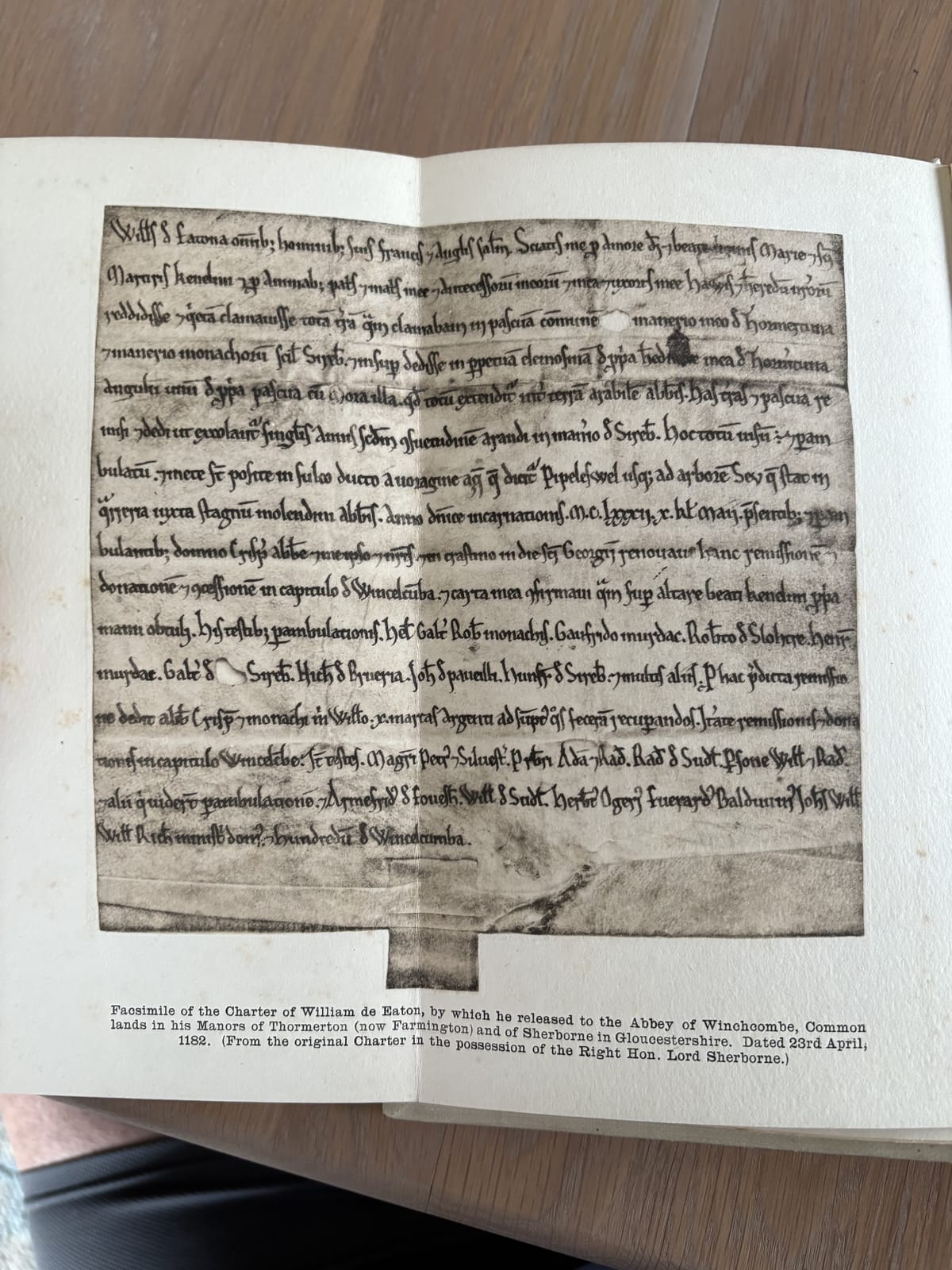
Today’s newsletter addresses the very first document in the muniments. This is a “charter” - a legal agreement about land, written and signed 23rd April, 1182. That’s 843 years ago this Thursday, so I thought I’d write about it! It concerns a parcel of land falling partly in Farmington and partly in Sherborne. It is the oldest surviving document detailing Sherborne, other than the Domesday Book. There was likely an older charter written around AD 800 passing the estate of Sherborne from King Coenwulf to Winchcombe Abbey, but that had already likely been destroyed in a fire before the date of this charter.
The document details the passing of land from “William de Eaton” to Winchcombe Abbey. My understanding is that he had held some of this land in both Farmington and Sherborne as a tenant and released that back to Winchcombe Abbey, along with some land of his own in Farmington under the terms of “frankalmoin.”
Fundamentally, he’s giving land to the abbey in return for prayers being said for him and a bit of silver too. I may be wrong – it’s a little difficult to follow and it uses concepts I’m unused to. Here’s the image of the agreement:

Here’s a translation of the main part:
William de Eaton, with greeting to all his men, French and English, for the love of God and of the blessed Virgin Mary and the holy martyr Kenelm, and for the souls of his father and mother and of his ancestors, and for his own soul, and that of his wife Hawis, and the souls of their heirs, has rendered and quit-claimed all the land which he claimed in common pasture in his Manor of Thormaton and in the Manor of the Monks, to wit, of Sherborne. And given in perpetual arms of his own inheritance of Thormaton, a corner of his own pasture, with the moor there lying in the arable land of the abbot, the lands and pastures granted and released may be tilled yearly according to the custom of ploughing in the manor of Sherborne, viewed and surveyed and bounds placed in the ditch leading from the pool of water called Pipeleswell, as far as the tree Sev, which stands in the stone quarry near the millpool of the Abbot, in the year 1182, on the 10th calends of May, in the presence of the Lord Crispin the Abbot himself and their men. And on the morrow, being St George's Day, the 23rd of April, he renewed the grant in the Chapter House of Winchcombe, and by this charter confirms it, and with his own hand has offered it upon the altar of the Blessed Kenelm. Witnesses to the survey in consideration whereof, the abbot and the monks have paid him 10 marks of silver. Witnesses the Survey (“perambulation” ) Helias,Walter and Robert (monks); Geoffrey Murdac ; Robert de Slohtre; Henry Murdac (etc etc)
I have the following commentary to make:
It’s 1182, 120 years after the Norman invasion, yet clearly there is differentiation between the “French” and the “English” in William’s mind. That’s fascinating. It also shows a degree of integration.
Hawis – his wife’s name was a name introduced by the French after 1066 suggesting perhaps that William De Eaton and his wife were both French in origin, from the ruling aristocracy.
The charter uses the name Thomerton - this was the accepted name of Farmington before it evolved over the centuries into its current spelling and pronunciation. we should bear this sort of evolution in mind when we compare old features and maps.
The document suggests that a rotational crop system was being used in Sherborne and that it was considered important to comply with this system.
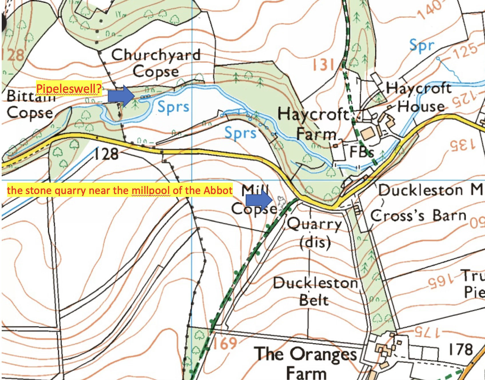
The boundaries described are very short and vague. They doing really make sense to me. But they mention a pool of water called Pipeleswell. In Anglo-Saxon, a “pipe” is a ditch or small stream and a well is synonymous with a spring. I have a suspicion that the spring connected or adjacent to a man-made “leat” at the very western end of the parish, on the Brook, may be this point.
I suggest the mill pool of the abbot may be referring to the area just upstream of Duckleston Mill, once called Sherborne mill and I think possibly called Abbots Mill before that. There is an old quarry immediately to the south. Old charters often made mention of prominent trees but I’m not sure what the tree “Sev” means. These are just guesses. I have marked these possible positions on the map below.
That’s all for this post. I can’t help but wonder if those clerics and Frenchmen and Englishmen all those years ago expected their document to be considered 843 years in the future. Would they recognise the landscape? I expect they would. I wish we could question them more but this signal channel is short and brief. And now is closed…
