An 1824 map of Sherborne
Adding to our understanding of the local heritage landscape
At a meeting of the Gloucestershire Local History Association the other day I was pointed towards a useful map that includes some interesting detail on Sherborne. You can see the whole map at this link here, and below is an excerpt.

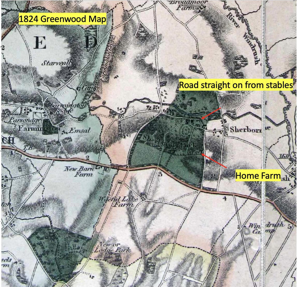
Greenwood Map 1824. Note good representation of the lakes.
Christopher Greenwood was a notable British cartographer who, along with his brother John, produced many detailed county maps in the 1820s. These maps are known for their accuracy and detail, often including roads, buildings, property boundaries, and topographical features. Importantly in relation to our recent research this 1824 map shows a clear parish boundary that matches the boundary today. This is the earliest record we have of the boundary. Note too, the relatively significant “road” shown that today is a simple footpath that runs from Great Rissington, north of Broadmoor, across to Farmington. This map is 1” to 1 mile, and therefore is at an identical scale to the 1827 First Ordnance Survey (called Old Series, and often incorrectly referred to as an 1805 survey map). This 1824 map however represents the two lakes in the village a little more successfully than the OS map which shows them as a simple line - see below:
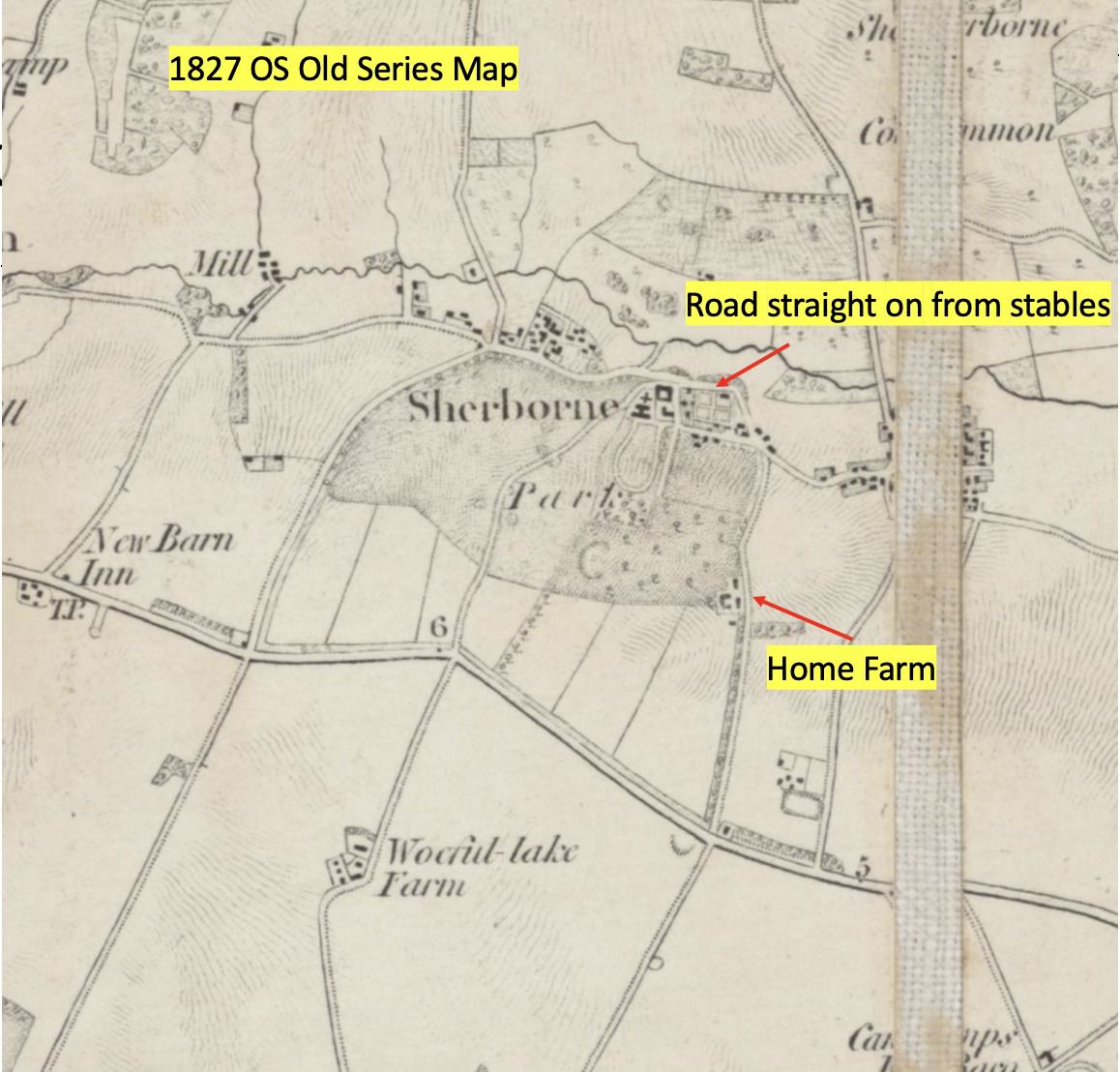
OS Old Series map C 1827. Note poor representation of the lakes - a squiggly line.
It is interesting to do a comparative analysis with the even earlier two estate plans created between about 1817 and 1820.
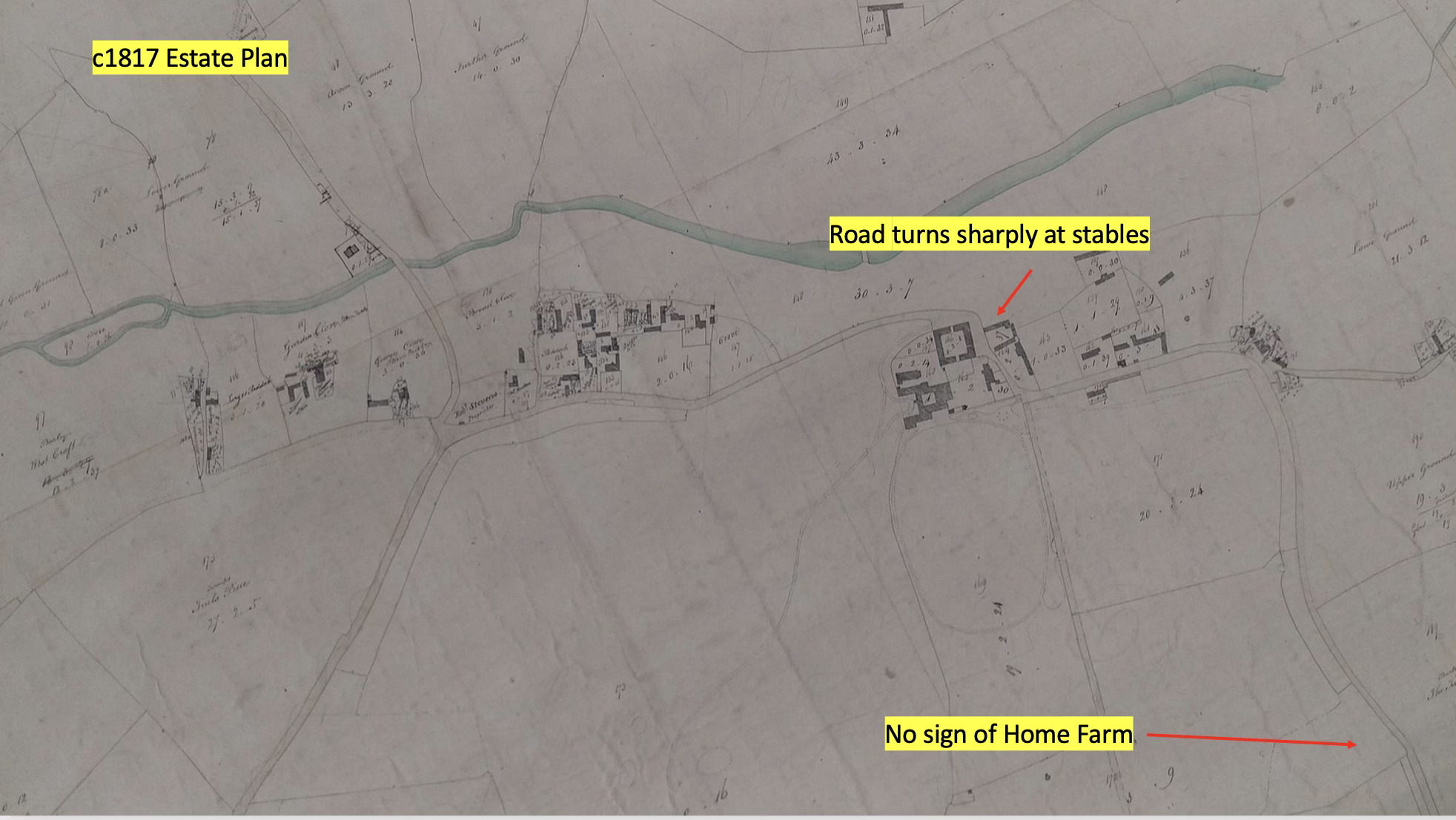
Estate plan c 1817.
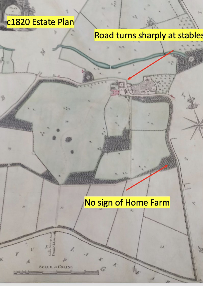
Estate plan c 1820.
Both these estate plans are at a better scale than the first two maps, but their purpose is different. So we actually have a relatively short period of time of these 4 plans and maps, between about 1817 (I estimate) and 1827.
- c 1817 estate plan - scale not given but probably 6 chains to 1 inch
- c 1820 estate plan - 6 chains to 1 inch in detailed parts
- 1824 Greenwood 1” to 1 mile"
- 1827 OS Old series 1” to 1 mile”
The key things to note include the appearance of Home Farm between the early estate plans and the maps, which narrows its build date down to the first years of the 1820s. Note too the “new” bit of village road. In the estate plans it shows that the original route of the village road took a sharp turn around the Stables. But by 1824 the new bit of road that runs past the dairy farm today has appeared.
Importantly, in the earliest of these plans and maps the lakes of the Broadwater and Narrowwater are clearly in place. Also the footbridge towards the East of the lower lake is clearly shown in both plans. This footbridge had disappeared by 1860s, but would have been quite a landscape feature crossing the lake when viewed from the area of Sherborne House. Lidar image analysis shows the footings of the bridge to this day. The fact that the 1827 OS map doesn’t appear to show the lakes can lead to a false interpretation, especially if the date of the map is confused and it is considered to be an 1805 map.
This has led some, including the National Trust, to assume that the lakes are an “accidental result of an early 19th C dam being created” to power some unknown mill, downstream of the lower lake after 1805. A better assessment, I politely suggest, is that the maps indicate the lower lake was created pre 1817, but after 1710 (when it is not present on Kip’s famous drawing of Sherborne). Archive material suggesting work on a number “sluices” in the mid 1700s in the parkland here reinforces our assessment that the landscape is designed to form an attractive serpentine feature in the style of 18th C fashion. There is no sign of any mill downstream on any map. Furthermore early census returns suggest only the Mill above Haycroft at Ducklestone was present in the early 1800s (then called Sherborne Mill) . There is no sign of any downstream mill in any map or any archive material relating to mills, at all, that I am aware of. There were mills built in the early 19th C at both Bibury and Lower Slaughter - both these were overshot mills of substantial size. There’s no sign of the remnants of any building from the early 19th C anywhere on the Sherborne Brook below the lower lake. I have looked on maps, on LIDAR, on foot and in archives. But there are multiple mill sites upstream of the lakes (I can refer to five in all). The continued and if I may say somewhat bizarre delay in publication of the National Trust’s Conservation Management Plan means I’m not yet clear if they have accepted this analysis. I’m not able to have any dialogue with them on this matter which is disappointing. We shall see, if they ever release the report.
It is clear that the period of these maps and plans (c1817 - 1827) was a time of significant development of Sherborne. Home Farm was built, as was Stones Farm towards the East of the village (built C 1818). The road from the stables to what is now the war memorial and school was changed, and we can see these developments in successive plans and maps above. You can take your own view on the timing of the creation of the serpentine lower lake - after all “History” is about interpretation of facts and new facts may contradict earlier assessments. That’s the historical process of conjecture and refutation and can be done respectfully, which I am trying to do. But the impact, if we are right, is significant. I don’t think we have an accidental landscape here - these lakes in the bottom of the valley are a key part of a designed landscape from c1740 at a crucial time, as fashions were changing. Capability Brown’s ideas were not yet apparent, but the Sherborne landscape gives a strong hint about the direction of that fashion. If the lakes are left to fill with silt, this heritage is lost, but more importantly, a lack of recognition of their importance puts Sherborne down the list of priorities for funding and means other features are left “fallow” to decline slowly with no purpose or apparent importance.
This 1824 map (new to me!) is another piece in the jigsaw puzzle to be analysed, and useful in providing for other purposes confirmation of the parish boundaries at an early date. I hope this bouncing around maps has been easy to follow - please let me know if I need to do a better job! I have a thick skin and welcome criticism. I accept that you might need to be a Sherborne resident to make sense of some of what I have said.
