CARTOGRAPHIC ANALYSIS: Dating the Sherborne Lakes
Resolving the Heritage Timeline Through Map Evidence
(I thought subscribers might find the following paper useful in understanding the fundamental issues surrounding the dating of the Broadwater and Narrowwater lakes in the valley bottom of Sherborne, key to understanding the community heritage. The paper is driven by the discovery of an 1815 Ordnance survey which on initial glance appears to support the NT contention that the lakes date from the early 19th C (c1815-1820), but careful analysis of cartographic issues suggests differently)
Discovery of an 1815 Ordnance Survey drawing appears to explain the National Trust's dating error for the Sherborne lakes, revealing a fundamental misinterpretation of early mapping conventions.
Key Finding: The NT has likely interpreted thin linear features on the 1815 OS drawing as evidence that the lakes did not yet exist, leading to their "early 19th century" dating. However, technical analysis of early Ordnance Survey mapping conventions demonstrates that thin lines on these maps represent features drawn to accurate scale - a 30-yard wide lake would appear as the same thin line as a narrow stream.
Heritage Significance Impact: This technical error has led to systematic underestimation of the landscape's heritage value. Correct interpretation supports 18th century (1730s-1740s) creation, fundamentally altering heritage protection requirements under planning policy.
THE DISCOVERY AND ITS IMPLICATIONS
What Was Found
A discovery prompted to me by John Phibbs, the noted landscape historian of an 1815 Ordnance Survey drawing of Sherborne has been located what appears to be the source document for the National Trust's heritage timeline assessment. This drawing shows the brook through the village as a thin linear feature, which the NT has interpreted as evidence that the lakes had not yet been created by 1815.
Why This Matters
If the NT's interpretation is correct, the lakes were created between 1815-1820, supporting their "early 19th century industrial byproduct" assessment. However, if this interpretation is wrong due to misunderstanding of mapping conventions, the heritage significance is fundamentally different - an 18th century designed landscape of potential national importance.
The Technical Issue
Early Ordnance Survey maps used variable scaling - some features (roads for military movement) were deliberately exaggerated, while others (waterways) were drawn to accurate scale where possible. A 30-yard wide ornamental lake would appear identical to a narrow stream on these maps - both represented by thin linear features.
UNDERSTANDING EARLY ORDNANCE SURVEY MAPPING
Historical Context
The 1815 drawing was created during the Napoleonic Wars by the Army's Ordnance Department for military purposes - specifically troop movement and defense against French invasion. Maps from this period prioritized different features according to military necessity.
Variable Scaling Explained
Roads: Deliberately exaggerated width for military visibility
- Example: Village road on 1777 Taylor map appears 1/16th inch wide on paper
- At 1 inch = 2 miles scale, this represents a 660 feet wide road - clearly not reality
- Cartographers exaggerated road width for comprehension, not distance accuracy
Waterways: Drawn to accurate scale where possible
- Military priority was lower than roads
- Represented as close to true scale as mapping precision allowed
- Critical Point: A thin line could accurately represent a 30-40 yard wide channel
The Misinterpretation
Without understanding variable scaling conventions, the 1815 drawing appears to show only a narrow stream. However, the same thin line that represents a stream also accurately represents an ornamental lake of substantial width when drawn to scale.
MAP-BY-MAP ANALYSIS
1777 Isaac Taylor County Map
- Scale: Approximately 1 inch = 2 miles
- Shows: Clear depiction of lakes in valley bottom, assessed as such by Historic England
- Significance: Pre-dates claimed 19th century creation by 40+ years
- Reliability: County-wide survey, less detailed but shows major landscape features
1815 Ordnance Survey Drawing (The Key Document)
- Map found here: (wikimedia commons, from British Library
- Scale: 1 inch = 2 miles
- Military Purpose: Troop movement and defense planning
- Shows: Brook as thin linear feature north of village
- Critical Analysis: This thin line could represent either narrow stream OR 30-yard wide lake drawn to accurate scale
- NT Interpretation: Assumes thin line = narrow stream = lakes not yet created
- Alternative Interpretation: Thin line = accurate scale representation of existing lakes
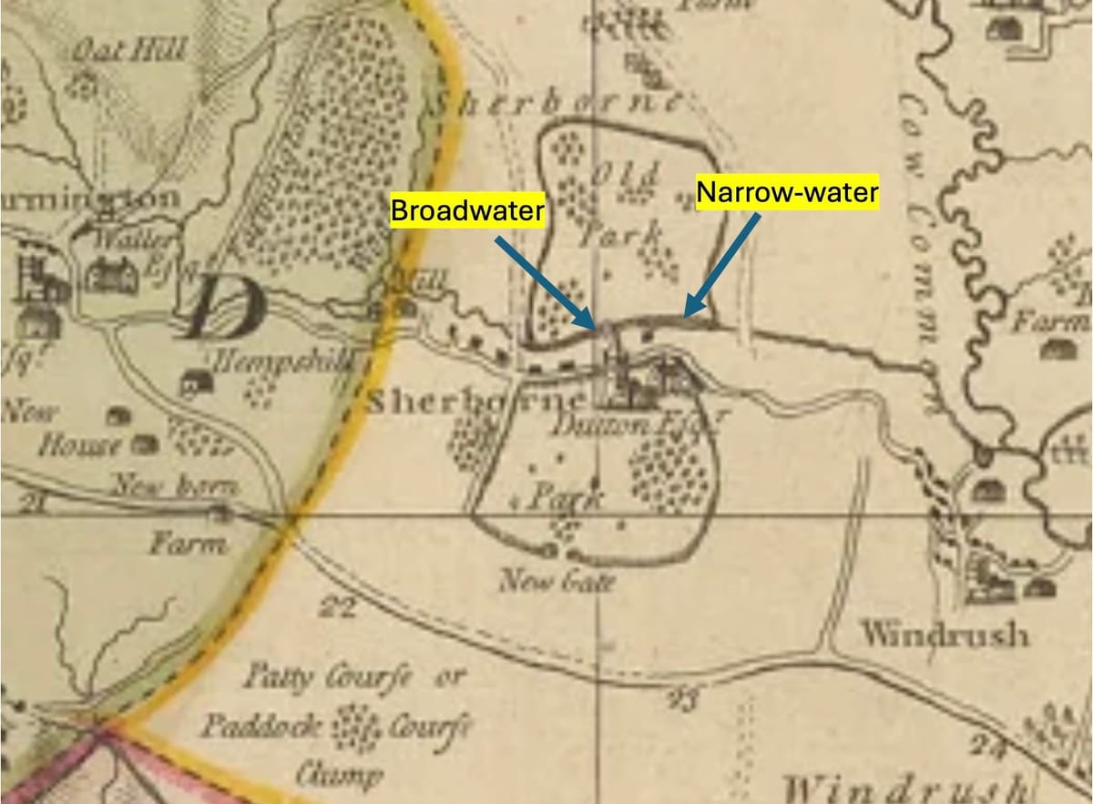
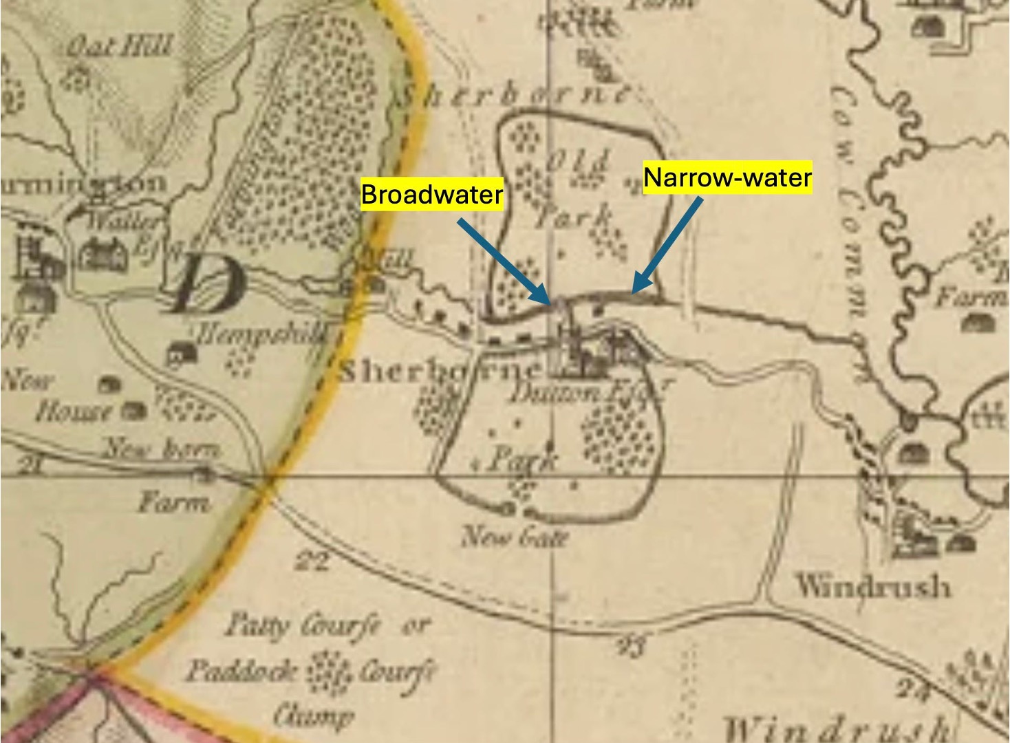
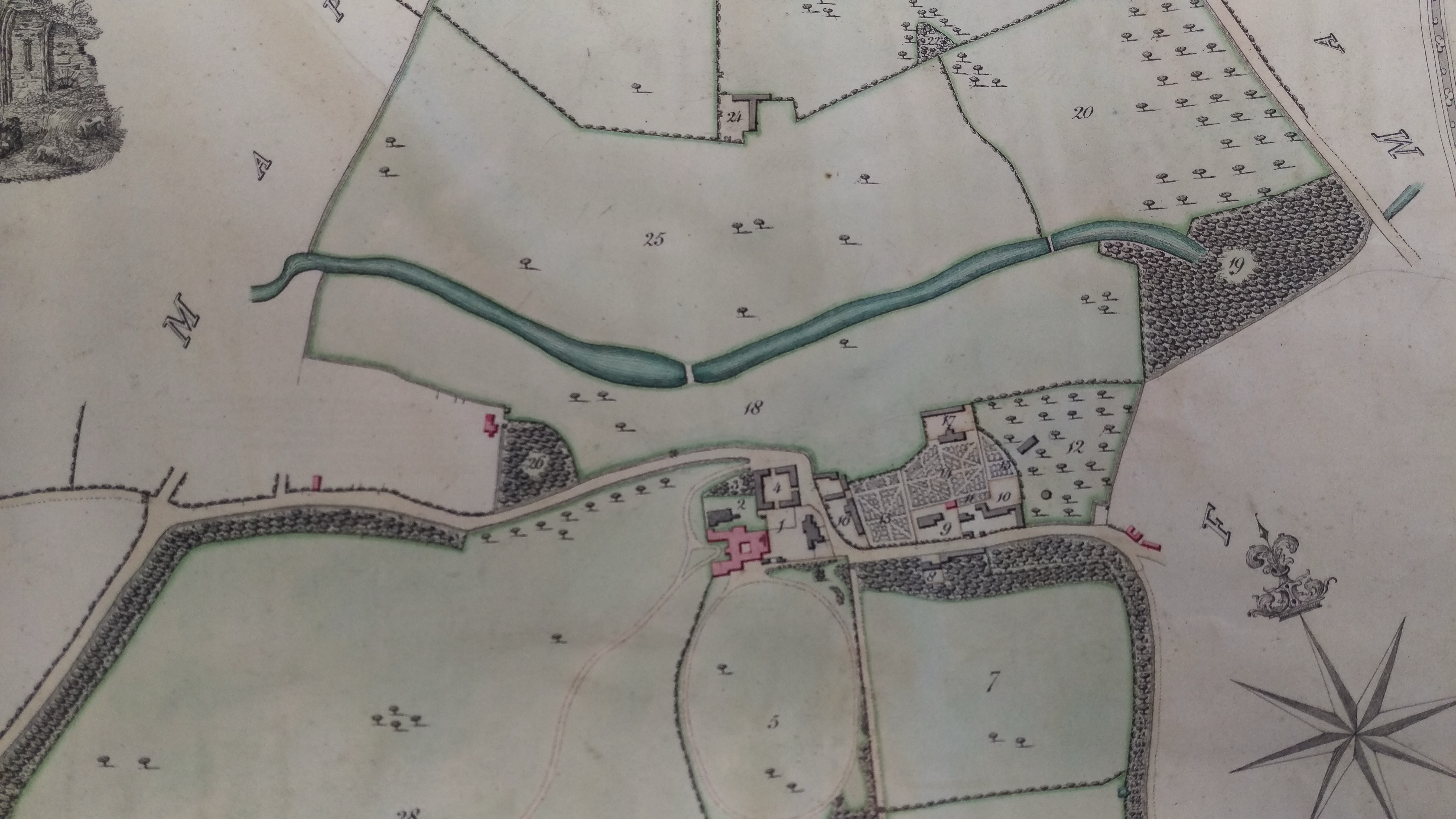
c.1818 and c.1820 Dutton Estate Plans
- Purpose: Estate management and field measurement
- Scale: Detailed estate-specific mapping
- Shows: Clear Broadwater and Narrowwater features accurately scaled
- Significance: Different purpose = different scaling priorities
- NT Window: They suggest lakes created between 1815-1820 based on this evidence
c1818
c1820
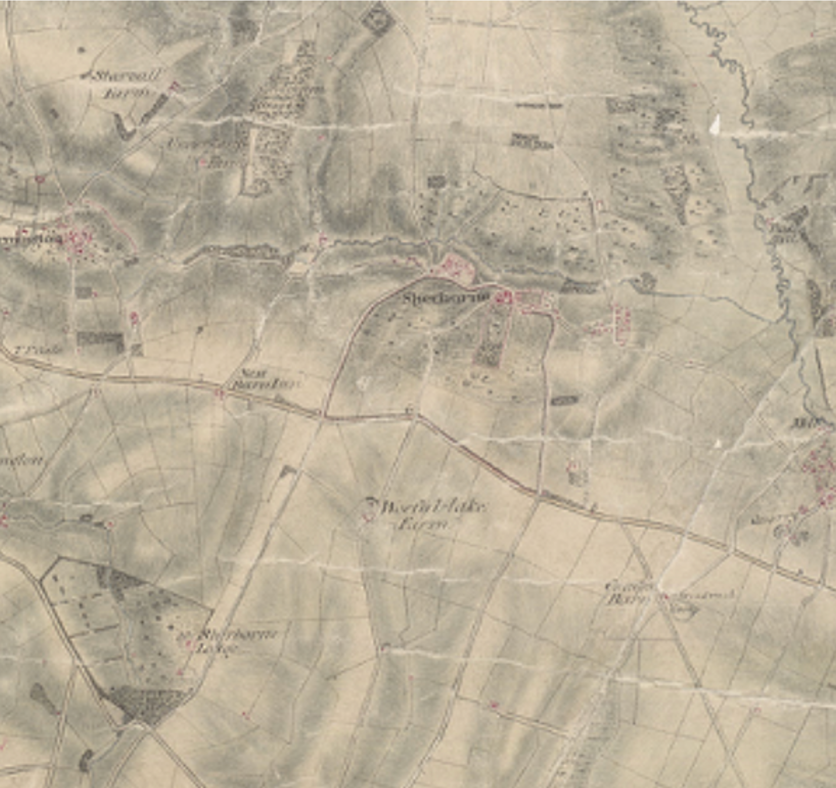
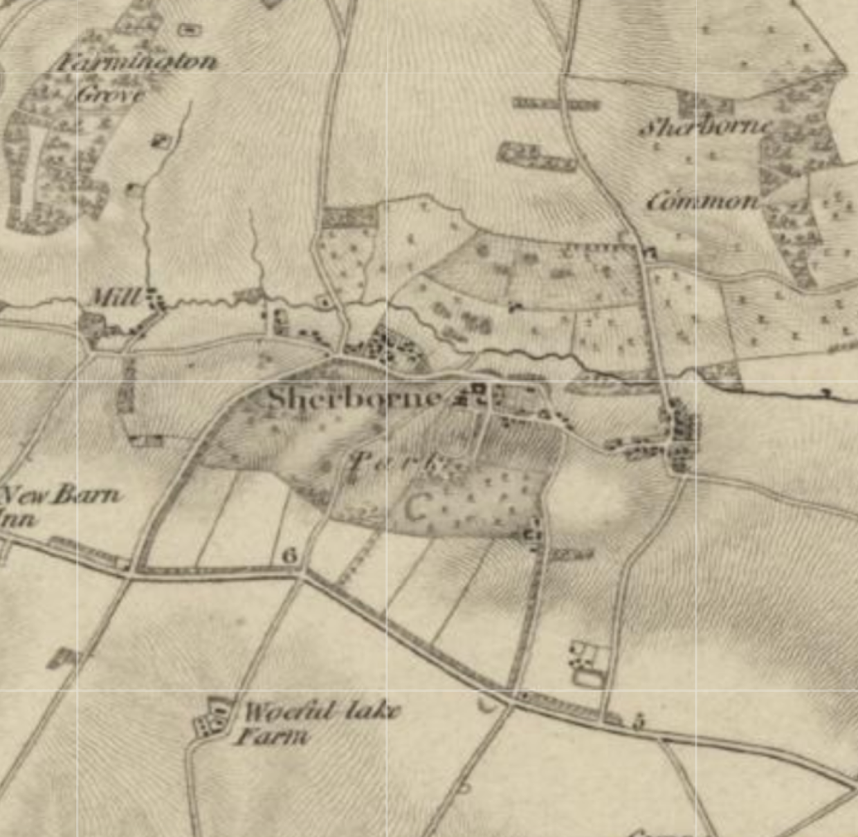
1827 First Series Ordnance Survey Map
- Scale: 1 inch = 1 mile (more detailed than 1815 drawing)
- Purpose: Still military, but more comprehensive coverage
- Shows: Brook again as thin linear feature
- Analysis: If NT interpretation correct, lakes would have been removed by 1827
- Reality Check: No evidence of such massive landscape change in 7 years
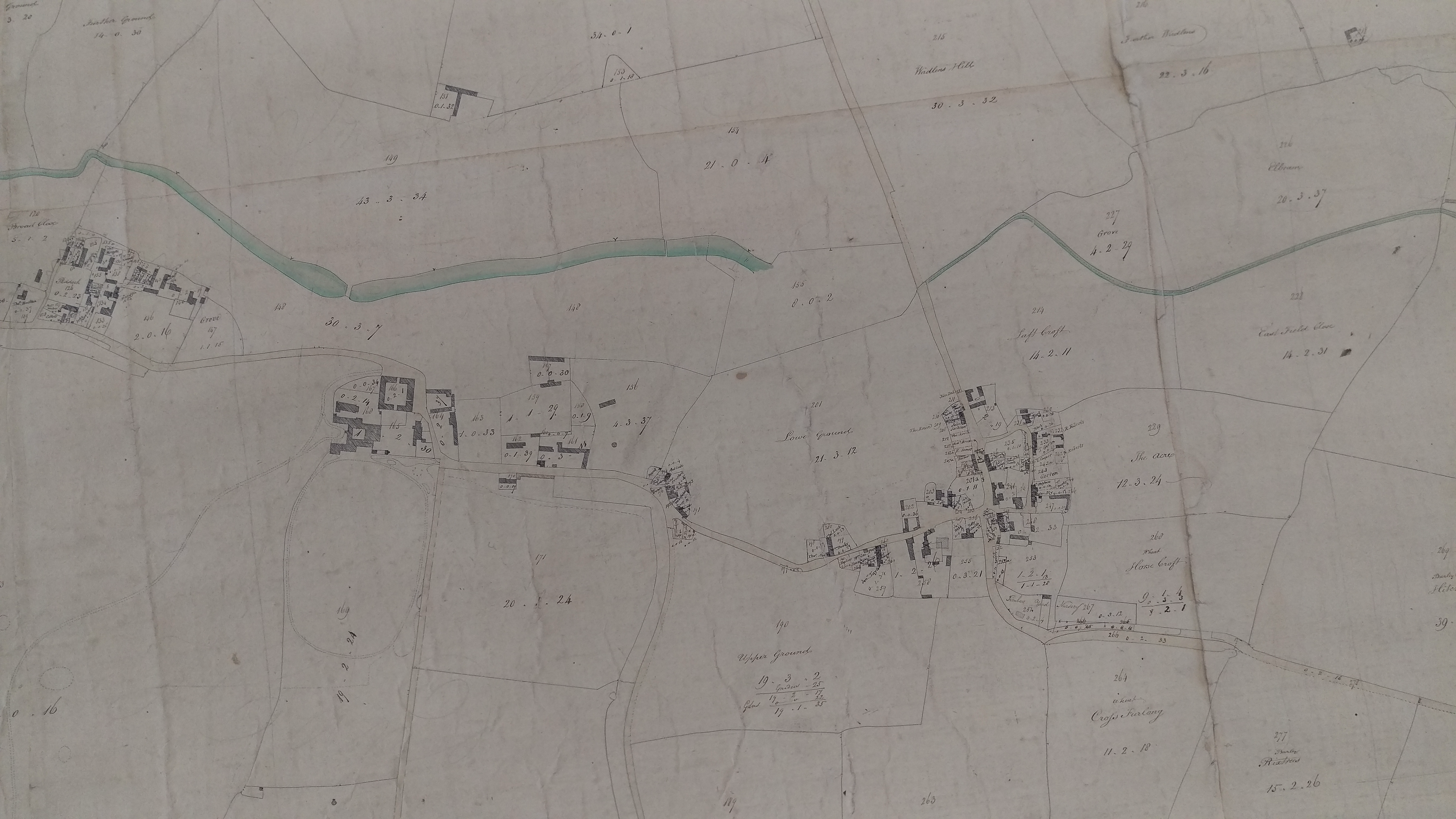
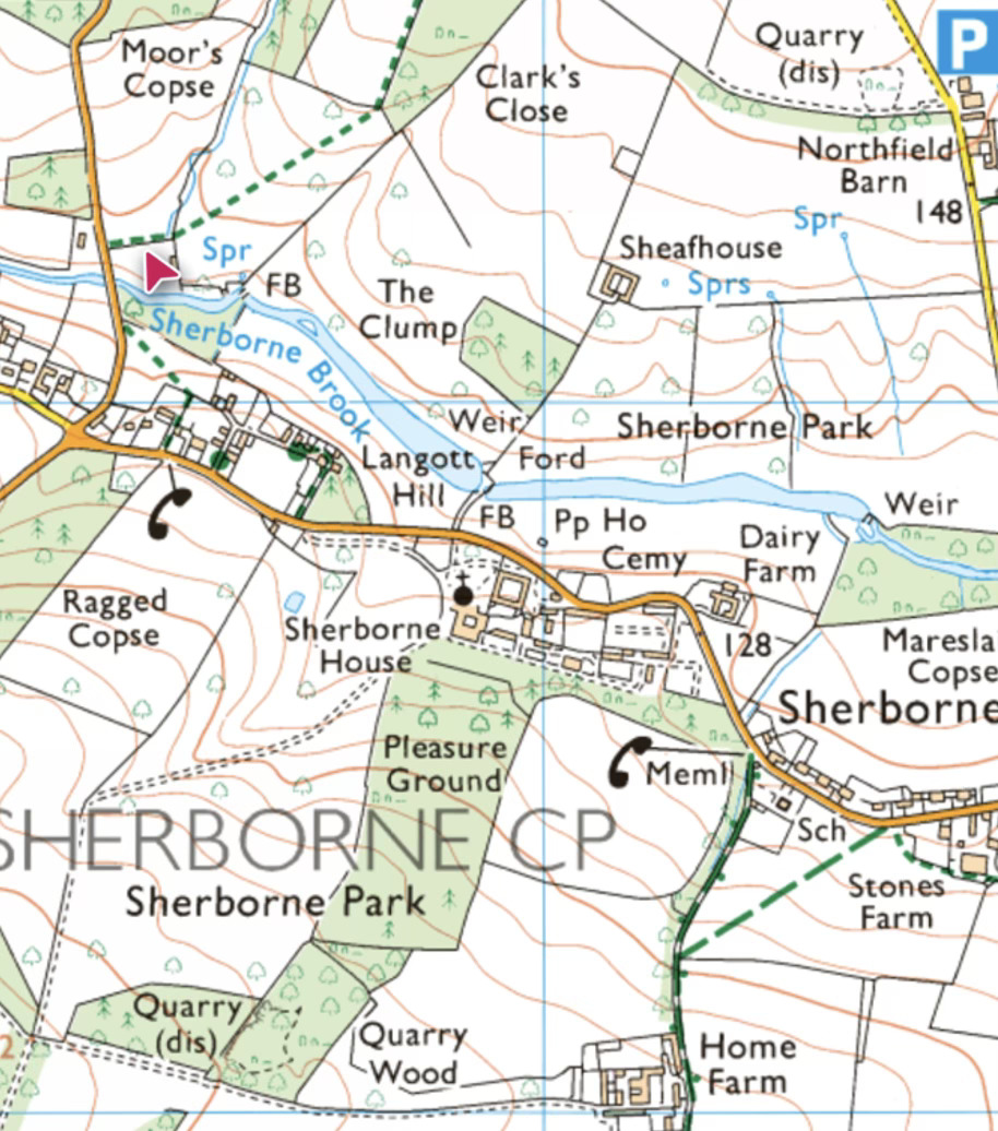
For completeness here is a modern OS map of the same area:
TECHNICAL EVIDENCE SUPPORTING CONTINUOUS EXISTENCE
Consistent Stream Entry Point
Both 1815 and 1827 maps show the stream entering Mareslaid Copse at exactly the same location where the broadened brook (Narrowwater) enters today. If the feature changed from stream to lake and back to stream, this consistent entry point is unexplained.
Missing Mill Evidence
NT verbal explanation suggests lakes created to power downstream mill, but:
- No mill structure shown on 1820 estate plan
- No mill structure on 1827 OS map or later
- No archival references to mill construction
- Other contemporary mills (Slaughters, Bibury) were substantial "overshot" structures that remain today
- No physical evidence of mill downstream of Narrowwater
Archive Evidence Contradiction
Estate archives show extensive hydraulic works in 1730s-1740s including "NEW POND" construction in 1740 - contradicting 1815+ creation timeline.
IMPLICATIONS FOR HERITAGE ASSESSMENT
Timeline Correction
NT Assessment: Early 19th century industrial creation (c.1815-1820) Evidence-Based Assessment: 18th century designed landscape (1730s-1740s) with potential medieval Broadwater origins
Heritage Significance Impact
Current Classification: Industrial byproduct of modest heritage value Corrected Classification:
- 18th century landscape design (potential Bridgeman attribution)
- Part of broader English Landscape Movement
- Possible medieval continuity
- National rather than local significance
Planning Policy Implications
Under NPPF Para 212, enhanced heritage significance requires "great weight" to conservation. An 18th century designed landscape warrants substantially stronger protection than early 19th century industrial features.
CONCLUSIONS
The NT's Logical Error
The National Trust's assessment follows logical reasoning but is based on a fundamental misunderstanding of early Ordnance Survey mapping conventions. Their interpretation treats the 1815 drawing as if all features were drawn to identical scaling standards, when military mapping priorities created variable scaling.
Technical Resolution
Proper understanding of variable scaling in early OS mapping resolves the apparent contradiction between different map sources. The lakes existed continuously from 1730s creation through all mapping periods, appearing as thin linear features when drawn to accurate scale on military maps.
Cartographic Expertise Required
This analysis demonstrates why heritage assessment requires technical expertise in historical cartography. The same map can support completely different conclusions depending on understanding of period-specific mapping conventions.
Heritage Protection Implications
Correct interpretation fundamentally alters heritage significance from local industrial feature to nationally important designed landscape, requiring enhanced protection measures under current planning policy.
RECOMMENDATIONS
For Heritage Assessment
- Heritage consultants should demonstrate expertise in early OS mapping conventions
- Multiple map sources should be analyzed with understanding of different purposes and scaling
- Archive evidence should be weighted alongside cartographic evidence
For Planning Process
- Current NT heritage assessment should be revised to reflect correct timeline
- Enhanced heritage protection measures appropriate for 18th century designed landscape
- Public consultation should be informed by accurate heritage significance
For Further Research
- Complete analysis of all available mapping sources with cartographic expertise
- Integration of archive evidence with corrected map interpretation
- Assessment of potential Bridgeman attribution based on 1730s-1740s timeline
This cartographic analysis demonstrates that technical expertise in historical mapping conventions is essential for accurate heritage assessment. The NT's dating error, while understandable, fundamentally misrepresents the heritage significance of this important landscape.
Roger Davies MBE QGM
Former Ordnance officer with expertise in cartographic interpretation
References: Estate archives D678 series, Gloucestershire Archives; OS drawings and maps 1815-1827; Taylor 1777 County Map; Dutton Estate Plans c. 1818 and c1820
