Dating the Lakes in Sherborne: A Challenge to Current Assessment
The Sherborne Broadwater is hundreds of years older than currently assessed.
This article examines the construction dates of the artificial water features in Sherborne Park (historically referred to as Home Park in archival documents). While this topic has been addressed previously, recent developments warrant a more comprehensive analysis. The key assessment is that the Sherborne Broadwater is likely to be much older than currently assessed by the NT.
The Current Controversy
In presenting their plan for the Sherborne Brook to the community over the past few weeks the National Trust confirmed their assessment that both lakes in Sherborne Park—the Broadwater and the Narrowwater—were created around 1820. This conclusion, I’m led to understand, is based on analysis of what they believe is an 1805 Ordnance Survey map and then circa 1820 estate plans that clearly show the lakes in existence. I respectfully suggest that the first Ordnance Survey map for this area was not done until about 1827 (although called the 1805 series), and their interpretation of this 1” to 1 mile map is (respectfully) flawed. The Trust's theory suggests these lakes were created to provide a head of water for a downstream mill created in the early years of the 1800s. No evidence for this mill has been provided.
Detailed justification for this NT assessment remains unavailable, as the Conservation Management Plan, originally promised in December 2022, has yet to be published. The following analysis challenges the 1820 dating and presents evidence for a significantly earlier construction period and therefore a very different heritage significance. I present this not to confront the NT, but in the hope that the importance of this landscape, at the very heart of the village, can be leveraged perhaps to obtain more funding – it’s older and more important than they have so far been willing to consider.
Research Sources and Methodology
This investigation draws upon several key sources:
Primary Sources:
I have done an almost forensic examination of the Dutton Archives (including detailed accounts) held at Gloucester Archives, specifically:
- D678/1/E1/2/1: Sherborne demesne survey from 1622
- D678/F12/2/1: Daily receipts and payments beginning 1708
- D678/1 F12/2/2: Sir John Dutton's accounts 1723-1733
- D678/1 F12/2/3: Sir John Dutton's accounts 1734-1743
Secondary Sources:
- Wendy Bishop's Ornamental Lakes: Their Origins and Evolution in the English Landscape (Routledge, 2021). This is an important book on the subject in hand.
- Steven Switzer's Introduction to Hydrostatics and Hydraulics (1729). Useful for understanding technology of the time.
- Analysis of various historical maps, plans, and images
Understanding Historical Terminology
According to Bishop's research, until well into the eighteenth century, people commonly used terms such as 'pond', 'pool', 'mere', or 'water' when referring to ornamental water features in designed landscapes. Importantly, the word 'pond' could describe a body of water of any size—what we might today call a lake was frequently termed a pond in the early eighteenth century. I believe this is the reason that important evidence has not been recognised because it has been dismissed using the modern interpretation of the word “pond”, suggesting an inconsequential feature in the corner of a garden. Let’s change that.
Technical Infrastructure of Artificial Water Features
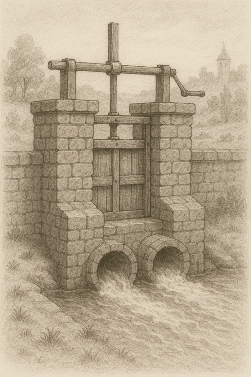
Artificial lakes or ponds required specific hydraulic infrastructure: weirs with sluices, grates to prevent blockages, and often fish traps. Sluice gates of this period were typically vertical lift mechanisms comprising a vertical door operated within a wooden or masonry “penstock” frame. The water level below a weir would naturally be several feet lower than the upstream level.
Here’s a sketch of a sluice weir, with a penstock holding the sluice gate. It’s not a perfect image but it gives us a good impression to consider.

Evidence from Kip's 1709 Engraving
The circa 1709 engraving by Kip of Sherborne House provides crucial visual evidence. The illustration shows the Sherborne Brook running along the left side, with particular significance in the area where today's "cascade" weir stands.
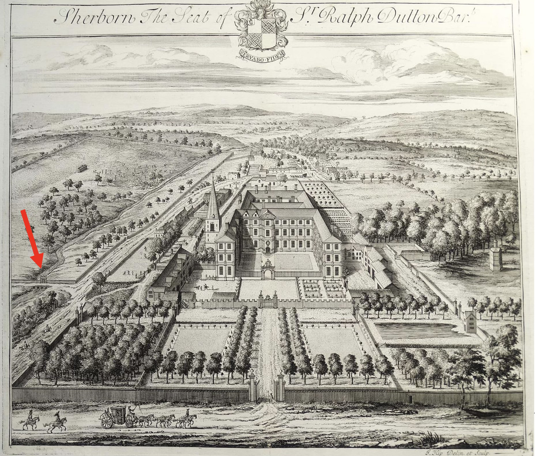
Close examination of this engraving reveals:
- A clear weir structure
- Four barrel sluices
- Different water levels upstream and downstream (I think, as there is today)
- Importantly, a structure atop the weir consistent with a penstock mechanism holding a sluice gate
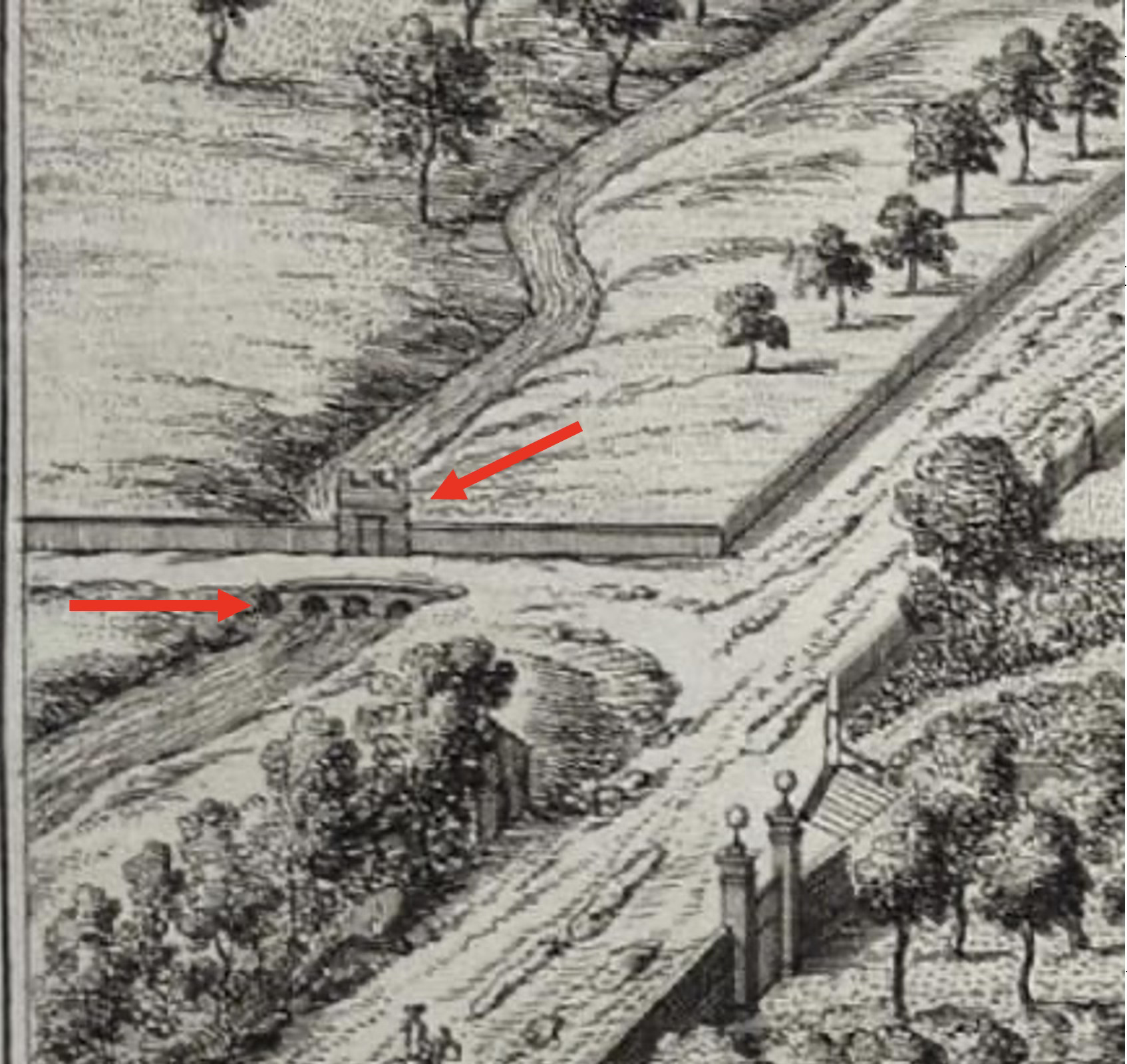
We can’t be absolutely sure it’s a penstock/sluice – but it looks like one, and it’s in the right place, on the brook, on a weir. This isn’t just a small bridge with an odd structure on top. Importantly, notice the apparent fall in ground just beyond the weir, just as there is a drop in the land today at this point.
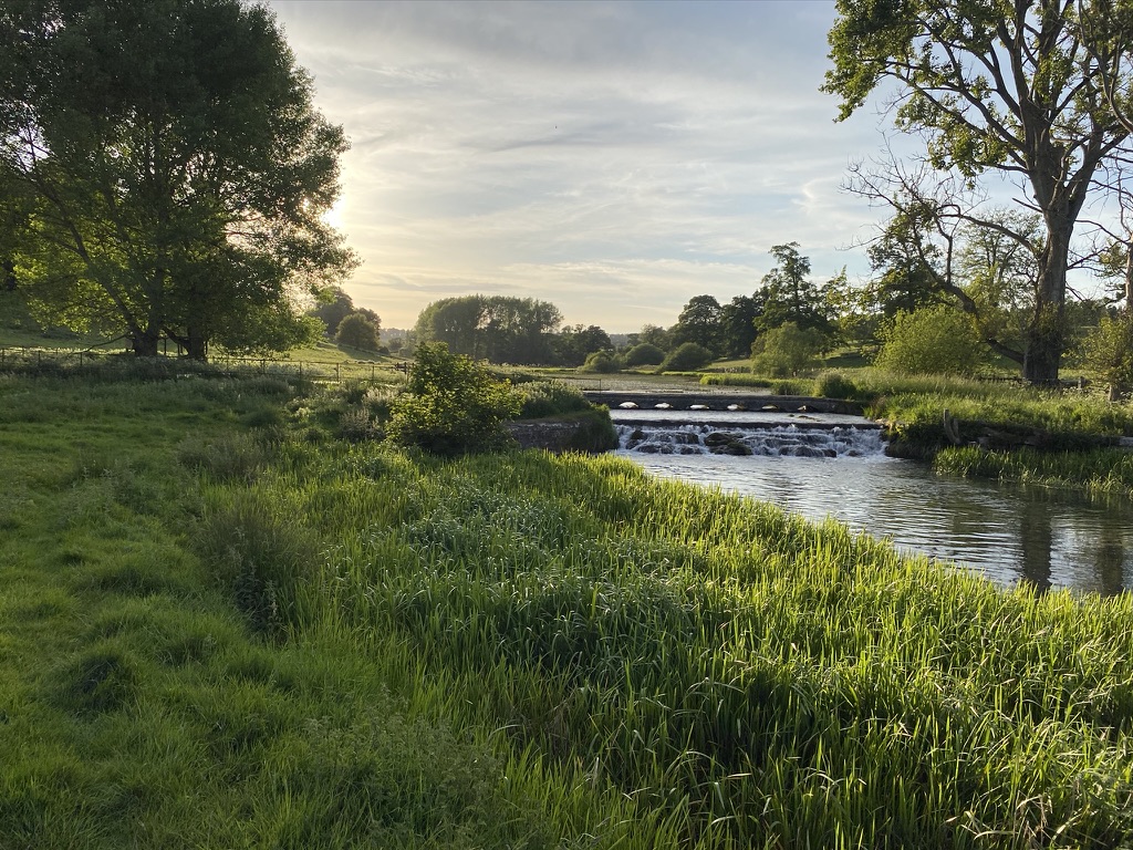
The cascade weir today. A sluice is built in to the weir on the left and there is a parallel fish trap too.
A perfect place for a weir and sluice. If it’s not a weir and sluice mechanism , what else is it likely to be, at this particular point in the landscape? I think the relatively narrow width of the Brook above this feature has led us down the wrong path. It could widen out, out of view and even if it doesn’t it presents a useful feature for the owners of the land prior to 1709.
This location would have been ideal for a fishpond to exploit the brook's trout population. Most estates of this size would expect to have a fishpond. In fact, it would be unusual if Sherborne, as an abbey-owned estate and then as a country estate in private ownership, didn’t have a fish ponds in the river. Additionally, during Sherborne's period as a centre for wool production under Winchcombe Abbey, sheep washing would have required exactly this type of infrastructure—a few feet of water depth enhanced and controlled by a weir. Sheep washing and shearing is crucial to Sherborne’s history, Cotswold history and the nation’s history. This is the logical place for it to occur, and bingo, there’s a weir to manage the depth of the water.
Archival Evidence from the Dutton Accounts
Now that we know to look for “ponds” in the archives, there is also other terminology, associated with these artificial bodies of water to look for. The Dutton family accounts contain extensive references to water management infrastructure, including 42 separate mentions of rivers, brooks, weirs, ponds, sluices, and grates between 1720-1740. Key entries include:
1726: Payment for "gins" (traps) for the river; payment to William Day for "drawing ponds and mending them"
1727: Payment for "ridding the brook in the Home Park and Mill pond"; making grates for the river in Home Park. Ridding is removing excessive weed growth and clearing the water.
1734: Reference to "Middleham weir" on the Sherborne brook. Where else could this be if not where the weirs are today?
1735: Masons “drawing “ponds” and opening drains”
1739: Masonry work at a fish “pond” in Home Park; payment for making a sluice for a “pond” in Home Park. If it needs a sluice, then it’s on a weir in a river, I suggest.
1740: Making grates for a "NEW POND" specifically in Home Park; payment for sluice and grate work; masonry payments for “pond work”. This could be the construction of a “new” second lake in the 1730s/1740
Physical Evidence
Two sluices remain in the area below the Narrowwater. One is clearly Victorian, constructed of brick with an associated turbine house. The other, located a couple of yards downstream, shows markedly different construction and dimensions using what appears to be much older masonry—evidence that cannot be easily dismissed. This could be a sluice constructed by masons making a “pond” in the late 1730s. In fact, in my view, I think it’s likely. This assessment was dismissed by the NT contractor who suggested it was reused stone from elsewhere, but I stand by it and contest my interpretation is more logical and now seemingly backed by archive material.
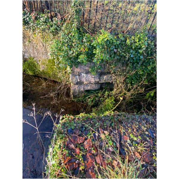
Images of the masonry sluice, possibly dating to the 1730s, below the turbine house sluice
The Middleham Weir Mystery
The 1622 Sherborne demesne survey (D678/1/E1/2/1) records "6 pools below the wall by the street" covering over 14 acres, indicating substantial water features existed in Sherborne by this early date.
Archive references to "Middleham weir" from 1734 onward, combined with the 1622 mention of "Middleham mead" (a 38-acre meadow), suggest this weir was located in the central portion of the brook running through the village—possibly at either the current cascade location or near the turbine house.
Fundamentally, my conjecture is that Middleham was a meadow in the heart of the village, between the village and the Brook, and that a weir existed there, called Middleham Weir, and that the most likely spot for this is where the current cascade weir sits.
Conclusion
The documentary and visual evidence strongly suggests that artificial water features in Sherborne Park predate 1820 by more than a century and indeed maybe much earlier. Kip's 1709 engraving provides evidence of weir infrastructure that could have been there for hundreds of years prior to that, while the Dutton accounts document extensive hydraulic works throughout the early-to-mid eighteenth century. I accept that these earlier features could have been adapted in the 18th and 19th C. My conjecture is that the weir around the current cascade was medieval originally, making the Broadwater several hundred years older than currently assessed and that the “New Pond” mentioned in 1740 is the lower lake, the Narrow-water. This had a masonry sluice that we can still see today, although a second brick sluice was put in at the end of the 19th C to house the turbine.
This evidence places these two water features within the broader context of early eighteenth-century landscape design, when many estates were creating and developing ornamental lakes in river valleys near their principal houses. Wendy Bishop’s book is full of grand houses making ponds in the 1730s and 1740s and we also know that the Dutton owner of this estate at the time was visiting these grand houses and their lakes with his new wife. Given my recent piece on the lakes/ponds in Lodge Park, it is clear that the lower lake there was being developed contemporaneously with the lower lake at Sherborne. Both parks then had vaguely Serpentine lakes in the bottom of the valley within a few years of Bridgeman’s serpentine in Hyde Park. I think that’s significant, given we know Bridgeman visited Sherborne on more than one occasion and the lower Lodge Park lake was being constructed within a couple of years of the experiment to see if a much bigger serpentine lake was possible there. What we ended up with was “Plan B” - and today that lower lake is forgotten. The historical importance and significance of the two lakes in Sherborne, particularly the Broadwater is forgotten too. I believe the lower lake was completed in around 1740, and then the stable block , which in my mind clearly sits above this lake deliberately as part of its design, was done by 1770, or thereabouts. To suggest that the stables came first and then 50 years later the lake was created seems back to front to me. My theory is further supported by evidence of a significant footbridge about 50m upstream of the turbine house, which clearly existed in 1820. I think it was built in the mid 1700s and was gone, rotted away perhaps, soon after 1820.
From a heritage perspective, this earlier dating significantly enhances the historical importance of these features, also connecting them to Sherborne's medieval significance under Winchcombe Abbey rather than merely to later agricultural improvements. As a community, I hope we can work with the NT to gain recognition for this and explore the important historical implications. I’m happy to sit down with anyone and show several reasons why a 1805 Ordnance Survey Map of Sherborne cannot possibly be correct. I’m very sure of my ground here…not just because I’m a former Ordnance Officer!
