For the want of a nail..
Knock on effects to the Sherborne Brook
After a few posts about esoteric stuff, this one is back to the nitty gritty. I thought it might be useful to describe a series of situations that is impacting the Brook and other aspects of our environment. This is something I have talked about before but as you’ll see there have been new, unfortunate, developments.
For a few years now the Sherbrooke Brook Support Group have been mindful of the “grips” on the verges in the village. These are the small trenches that lead road run-off from the gutter in the road into ditches or beyond. There the road run off can settle, drop any silt, and the “pulse” of heavy rain is slowed and delayed getting into the water system, causing problems downstream (such as flooding in Witney).
Theoretically it is the County Council Highways department who are responsible for arranging the grips to be cleared and gullies (which collect silt) to be emptied. It is the landowners responsibility to keep ditches and drains clear.

It is not the village community’s responsibility to clear the grips and help the flow of run-off off the road, but it is at least two years now since the grips were cleared by Highways. Frankly it needs doing every couple of months. In previous centuries there was a village linesman whose job it was to do this. Highways have clearly decided they cannot afford to do it and for the last few years the Brook Support Group have organised occasional work parties. We haven’t done that for a few months and I wanted to explain why.
On the road that runs towards the village crossroads, down from the A40, the road run off is guided to the right hand side of the road as you go down hill. There are three grips, one about every 70 yards or so. These channels should take road run-off, and they feed it under the wall into Ragged Copse. The wall here was specifically built with passes under the walls over a hundred years ago to take this flow of water. After passing under the wall the water is fed into rough woodland where it can soak away slowly. That’s what should happen.
Regrettably the volume of rain in recent years has pushed significant debris under the wall and the channel under the wall and beyond is blocked. So even if we clear the grips, the water cannot flow. The area under the wall and beyond is the property of the National Trust, we can’t trespass and start digging, and I have had good dialogue with them but they have not yet been able to provide a solution. I think a digger is needed. It would make sort work of the issue.
So - what happens next to the road run off - well it barrels on down the road. You will see that this scours a channel beside the road to the hard core underneath - and this is being eroded. The silt in the run off is dense, and some is caught in the “gullies” under metal grids on both sides of the cross roads. Frankly these gullies are overwhelmed and it only takes a couple of weeks for them to fill. The water carries on to that hundred yard stretch between the cross roads and Waterloo Bridge.
You can see that the margin of the road is being eroded very rapidly. The hard lumps of rock that form that underlying structure of the road are pushed down hill. At the very bottom there’s another grip which we clear occasionally, but before then something significant happens. The grit and the rock is dropped by the flow at the bottom of the hill. It has filled the edge of the road up and now protrudes into the main carriageway.
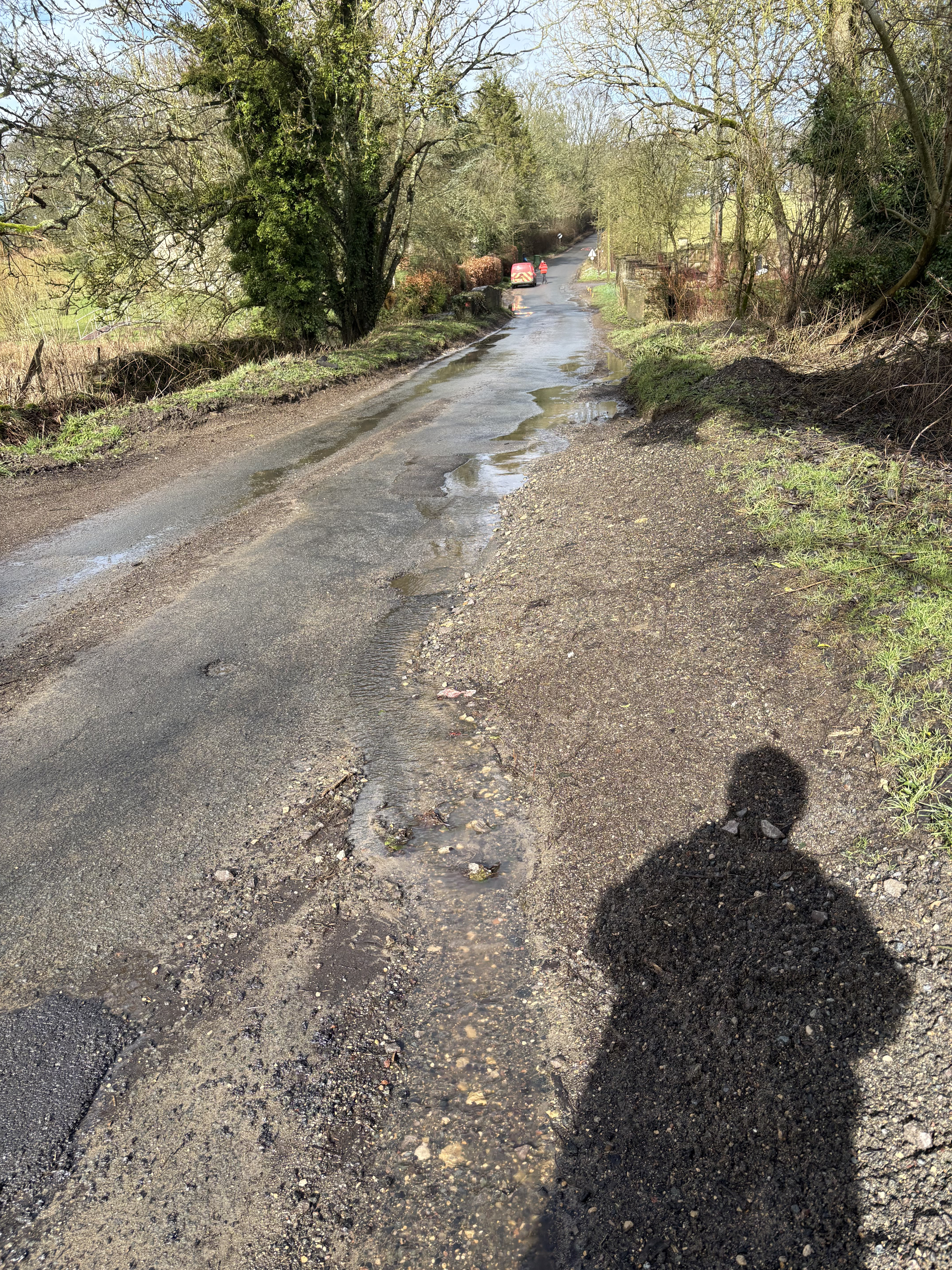
The peculiar action of the water here actually “grades” this debris with the lighter debris to the right, and the bigger, heavier, harder rocks get pushed out into the main road.
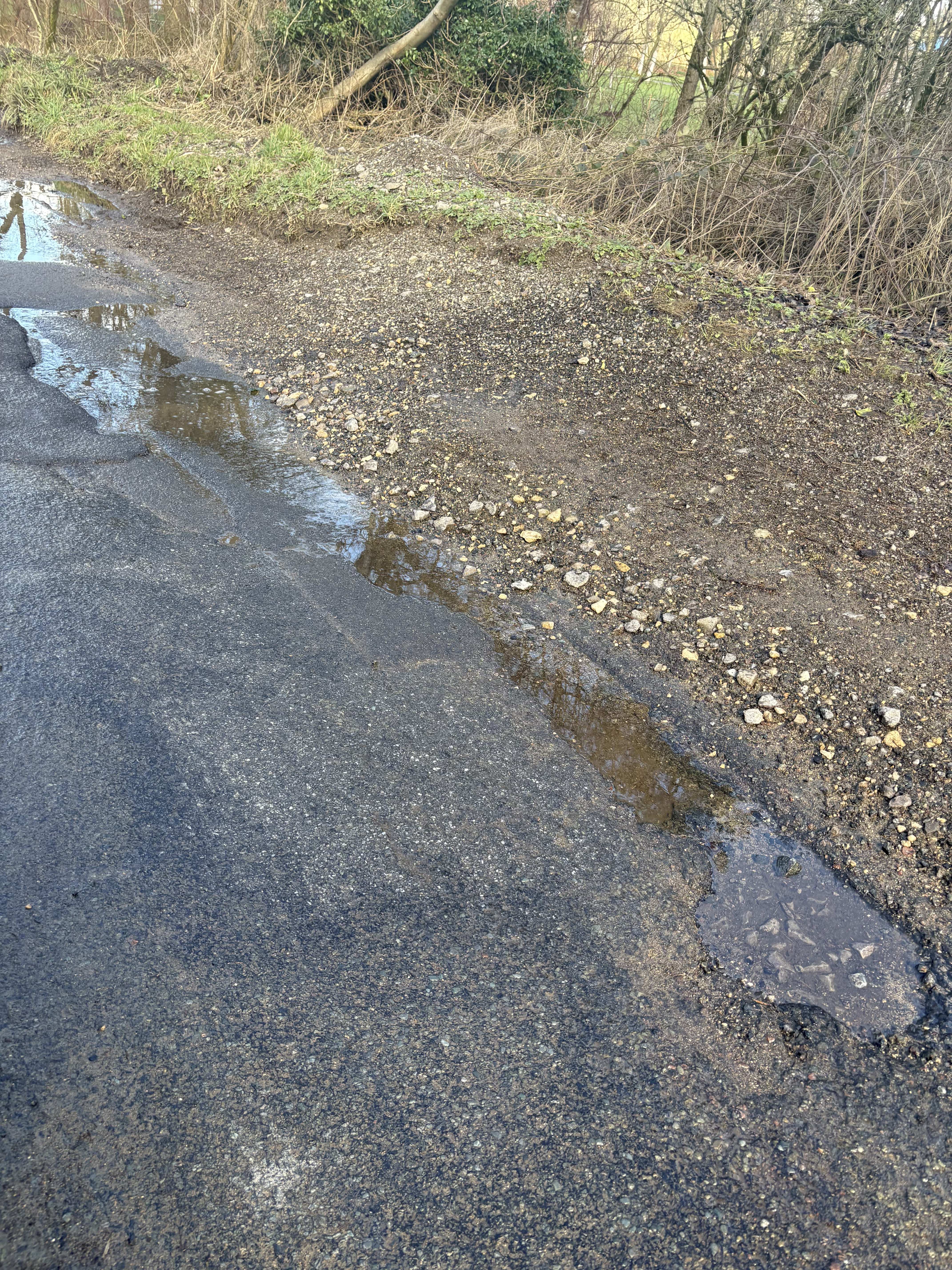
So - what happens next? Well the road here is used by all sorts of vehicles including 40 tonne trucks. The hard rocks are pushed right into the path off the wheels of these heavy trucks. 40 tonnes of force push the rocks into the relatively soft tarmac surface, destroying it. As a result potholes rapidly form. The road here has been repaired about 5 times in the last year. Because the water is flowing constantly, the potholes are filled with water and invisible. Vehicles are damaged and cyclists injured.
A few weeks ago on 27 January I became frustrated with the short-sighted approach of the Highways Department who seemed happy to fill the holes (not very well in my opinion) and return barely weeks later to repeat the exercise without addressing the cause, so I specifically reported the gravel beach and rocks on “fixmystreet”. I got the task number 7038682. As usual the report was acknowledged and I received an update saying the matter would be addressed. Yesterday at 11.19 I received an update from Gloucestershire County Council saying the matter had been addressed and repaired.
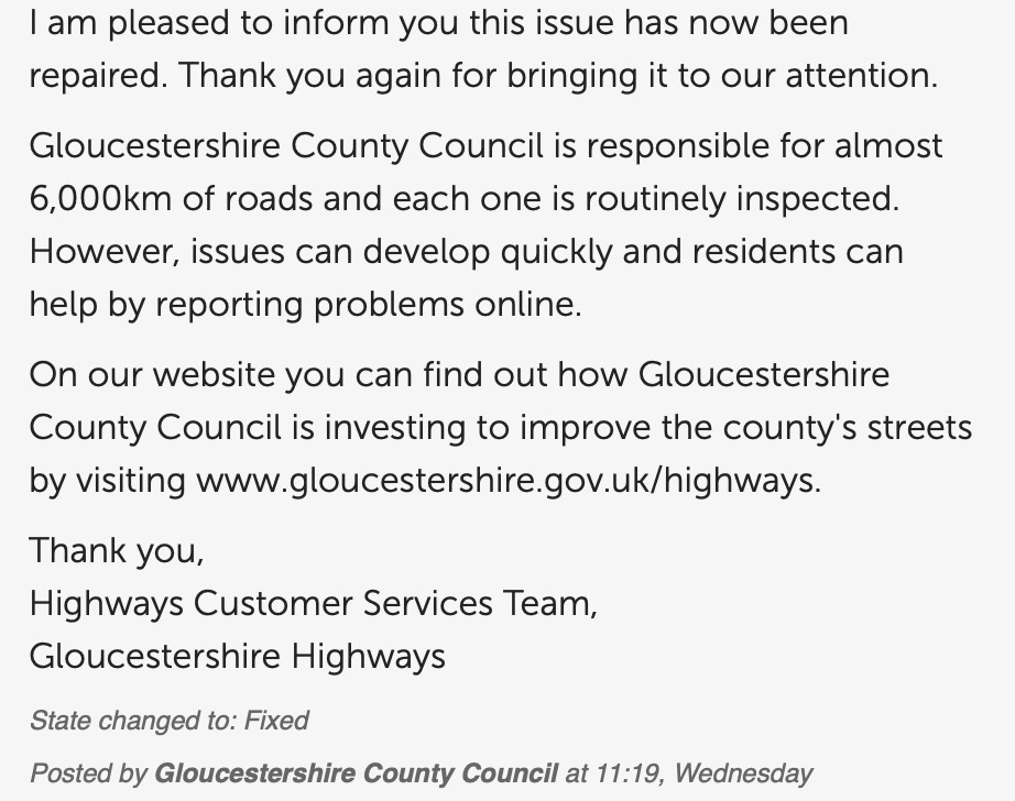
This surprised me, so I went to check. I’m afraid to say that the site has not been repaired, there is no evidence of anything work having taken place and the problem remains. I called the Highways Department and very politely reported the facts and that the road had NOT been repaired. The lady answering the phone said she would pass the matter straight to her supervisor. I haven’t yet had any follow up.
I have kept the Parish Council in the loop. They too have been actively pursuing the Highways Department, and prior to yesterday they had succeeded in persuading a Highways manager to come and visit in a couple of weeks time, and the PC have also asked me to be present and I believe the NT will be invited. This is great, and I appreciate the efforts of Yvonne, the PC chair, to arrange this. I let Yvonne know that we have had two previous visits from Highways Department managers neither of which led to any useful outcome.
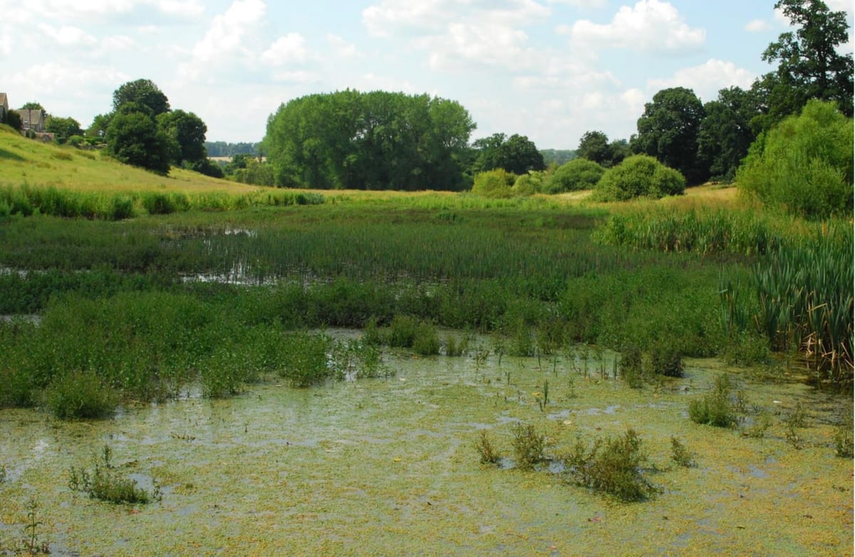
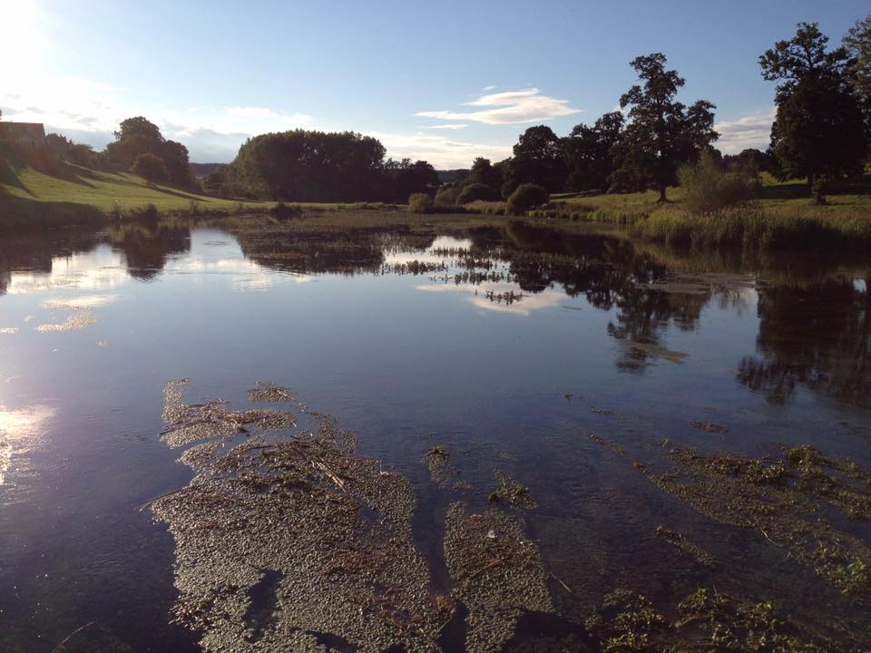
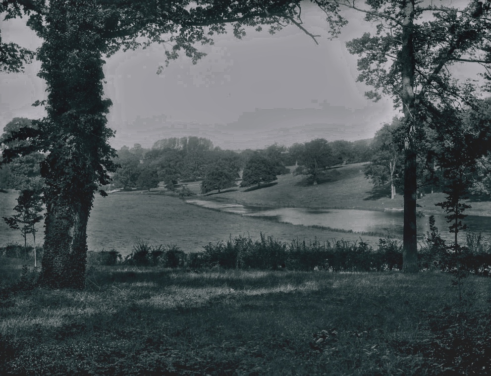
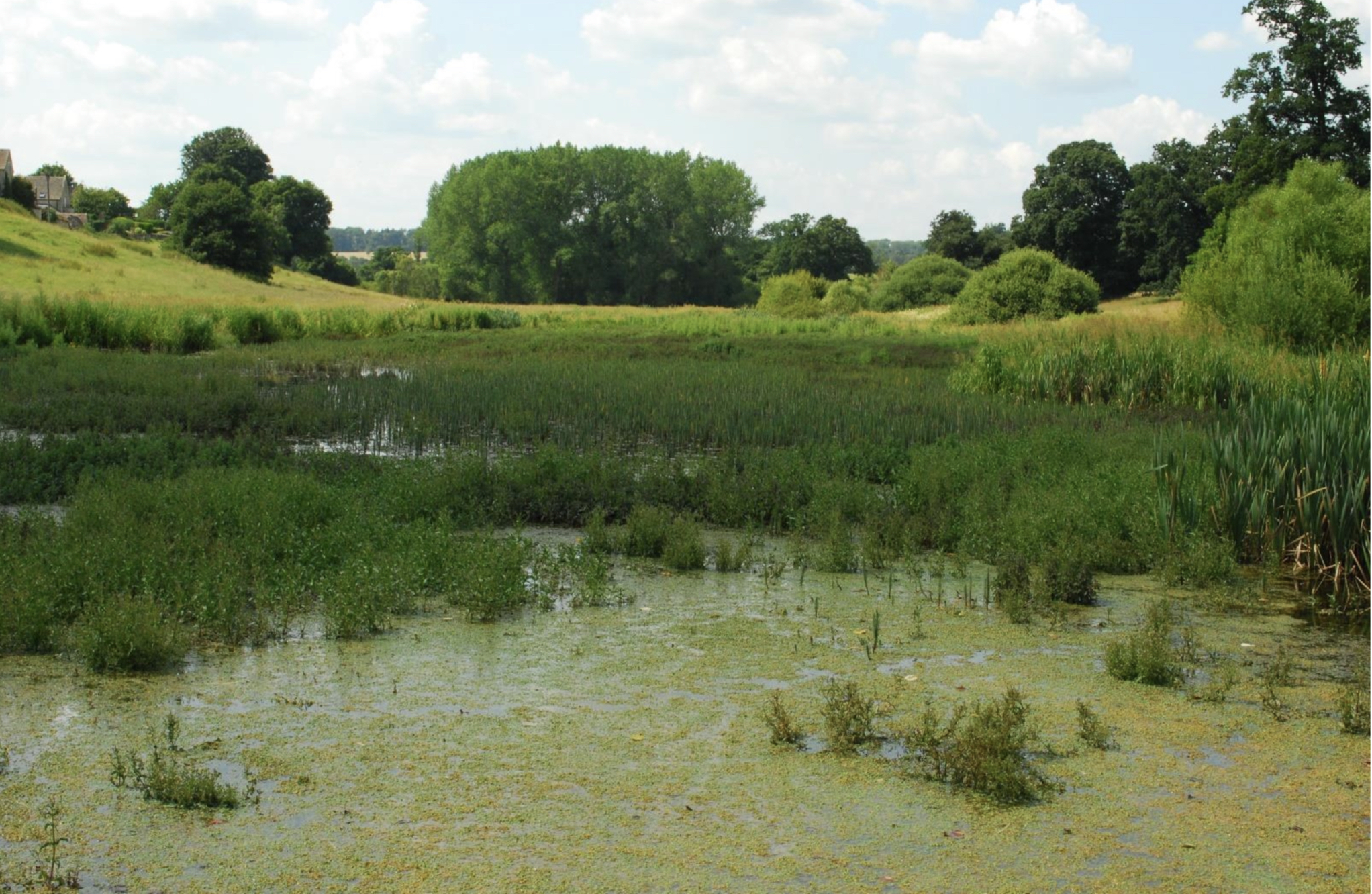
Meanwhile - the silt isn’t dropped here in the potholes…. the silt carries on and is dumped into the Brook. We, the Support Group, measured the quantities entering the brook a few years ago and the volume was remarkable. About a tonne for every rain shower. The silt doesn’t come from upstream , because the dredged lake at Haycroft acts as a silt trip for that. The silt entering Waterloo bridge then flows downstream until it hits the Broadwater where the flow slows, the silt drops and the once mirrored lakes as a result have been turned in to swamps. One factor follows the other. For the want of a nail, we have a swamp in place of the beautiful open water we once had.
Before:
After:
So what can you do to help? :
- Use Fix My Street to report potholes and other road issues. I’m about to re-report the beach.(note: if the pothole is deep it counts as an emergency you can report via the phone lines)
- Write to our County Council Highways Department.
- When the next county council elections come round make sure you ask the candidates to champion our cause if they want your vote.
- Support the Parish Council’s efforts. I know they are chasing the NT on their responsibilities and engaging with Highways.
- Volunteer to help the Brook Group clear the grips as soon as it makes sense to do so. 20 minutes with a spade works wonders, provided there’s a place for the grip to flow to.
- Maintain a polite amount of pressure on the NT to address their responsibilities, and ask your Parish Councillors to do this too - engage with them, it really empowers them. Details are at this weblink. You can also subscribe to weekly updates from the PC.
