Is Sherborne's Roman history a bigger deal than we realised?
I’ve been collating Historic Environment Records for Sherborne, considering what they tell us about our past. Today I’m looking particularly at the Roman period. Add archaeological evidence, geophysical surveys, and what might be called social history to the HERs and a startling picture emerges of the roman period here in Sherborne.
The question isn’t “Was there a Romano-British villa in Sherborne?” Perhaps we should ask “How many were there?”
Evidence suggests remarkable settlement density across our parish. Multiple sites cluster within a five-kilometre radius. Many appear high-status, some possibly boasting mosaics and hypocaust heating systems. This wasn’t casual countryside occupation. Romans laid down a settlement template that perhaps medieval Sherborne inherited and built upon and maybe we can see signs of the pattern persisting today.
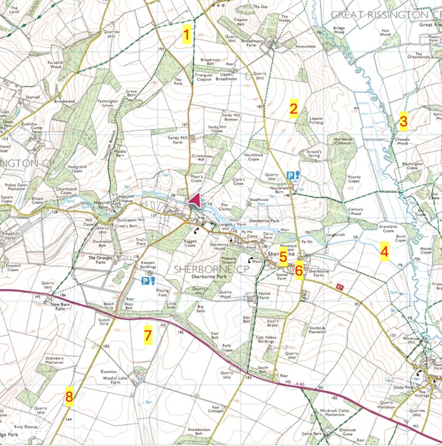
Here’s a local map showing some key locations.
What We Know:
1. Clapton boundary farm
Evidence of significant Romano-British farming sits just inside our parish boundary. Agricultural buildings, field systems, the infrastructure of prosperous rural life. [LINK]
2. Broadmoor Farm to Arnold’s Spring
A known Roman villa occupies this zone. Recorded, documented, waiting for fuller investigation. [LINK]
3. Chessels Field
Just over the Windrush towards Great Rissington, substantial remains lie buried beneath ploughsoil. Probably a farm or villa. The field name itself whispers secrets. “Chessels” often marks Romano-British villa sites elsewhere in Britain. Etymology preserves what archaeology obscures. [LINK]
4. Brook and Windrush junction
Recent geophysics revealed highly complex Romano-British settlement at this confluence. The patterns suggest a villa complex to me. Multiple buildings, courtyards, organised spaces. Water access, fertile land, strategic location. [LINK]
5. NEW Village centre discovery
Three months ago, electricity contractors buried cables through the heart of the village. Two archaeologists accompanied the work, watching for finds. I’m reliably informed they discovered evidence of a “significant and high-status Roman complex.” The report has gone to the County Archaeologist as protocol requires. The Historic Environment Record hasn’t appeared yet. When it does, this discovery may force significant reassessment. Romano-British life at Sherborne’s very heart, beneath our modern streets.
6. Stones Farm area
Previous community archaeology documented significant Romano-British agricultural activity here. Corn dryers, fields, boundaries, the working landscape that fed villa residents. [LINK]
7. Woeful Lake Farm
Significant Roman material appears around Woeful Lake Farm, just over the A40. Finds include a miniature Roman altar. Such objects suggest religious observance, perhaps a household shrine. Strong suspicion of substantial settlement here. [LINK]
8. The oyster midden
A curious concentration appears on the old deer course. Thousands of oyster shells cluster across this area. Romans adored oysters, considering them a delicacy. Such quantities suggest high-status diners nearby. Oysters travelled from coast in sealed barrels. They weren’t peasant food. The cost alone restricted them to wealthy tables. A midden typically sits tens of metres from the buildings it served. Centuries of heavy ploughing obscure any structures. Yet someone feasted on those oysters, discarding shells by the thousand. [LINK]
More Possibilities
Some speculation follows. Evidence exists but remains incomplete.
- A National Trust archaeologist showed me signs of a small Roman marching camp in Sherborne. Temporary fortifications, probably overnight encampment. I can’t reveal the location yet.
- I think I’ve found another, larger Roman military site. Perhaps. More field walking and investigation needed first before I reveal the site.
- Where was Sherborne’s principal villa? Underneath Sherborne House strikes me as most probable. Commanding position, spring access. Tell me I’m wrong.
- A curious spot west of Sally Coppice along the River Leach in Lodge Park may hold Roman archaeology. Other sites cluster upstream of the River Leach at Eastington ( a known villa site) , Turkdean (a villa site investigated by Time Team) and the Barringtons. The Fosse Way itself bristles with Roman settlements one would expect.
- Sherborne’s multiple springs would have attracted Roman attention. They venerated water sources, building shrines and temples. They exploited springs for practical purposes too. Clean water, irrigation, industry.
- Someone recently found a hypocaust tile in Sherborne. Hypocausts provided Roman central heating through underfloor channels. Such systems meant relatively high-status buildings. Not every farmhouse boasted heated floors.
- Social history mentions a Roman mosaic discovered maybe forty-five years ago. Apparently covered and hidden afterwards. The story persists in local memory.
- I think there are other as yet unrevealed Romano British sites in Sherborne.
Rethinking Density
Traditional scholarship scattered Romano-British villas sparsely across countryside. One every ten or fifteen kilometres perhaps. Recent archaeological assessments challenge this comfortable spacing. In prosperous Cotswold areas where Roman life flourished, several villas within five kilometres wasn’t unusual. Wealth concentrated. Settlement clustered. The landscape filled with farming estates, each producing surplus for market. I think that’s what we have here. Here;s some light residing on the subject:
LINK 1
LINK 2
Bottom line: It’s beginning to be clear that considerable Roman activity shaped this landscape.
Changing Perceptions
Not long ago, a respected historian stated “there’s no Roman villa in Sherborne.” The accumulating evidence suggests otherwise.
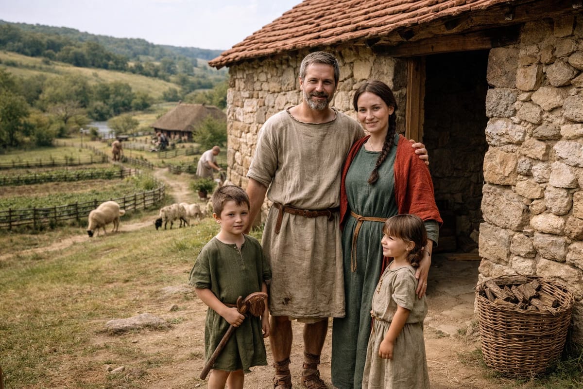
Romano-British settlement eighteen hundred years ago defined Sherborne as a community. A large villa perhaps with some form of dignitary. Sophisticated farms surrounding it. Local workers employed across estates. That template persisted through medieval reorganisation. It survives today in settlement patterns, field boundaries, perhaps even our village centre’s location. Here’s my AI interpretation of a scene in Sherborne 1800 years ago, with the Brook winding through the landscape, the key to understanding Sherborne.

Much remains hidden beneath buildings, ploughed into oblivion, or simply forgotten. Some reluctance exists to acknowledge this buried presence. Understandable reasons apply. No farmer welcomes crops excavated for archaeology at financial penalty. Householders might not want gardens destroyed by test trenches. No one welcomes metal detectorists trespassing across private land. All these are understandable responses to potential disruption.
Yet we should value this remarkable Roman heritage. We’re close to this history. It’s not stale stuff confined to museums. It’s personal, local, and beneath our feet right now.
Walk across Sherborne fields and you tread where Romano-British farmers worked. Stand in the village centre where Roman builders raised walls. Touch stones that Roman hands quarried and shaped. Here’s another of my AI images of perhaps a typical Romano-British Sherborne family, the brook in the distance. They look kind of familiar!
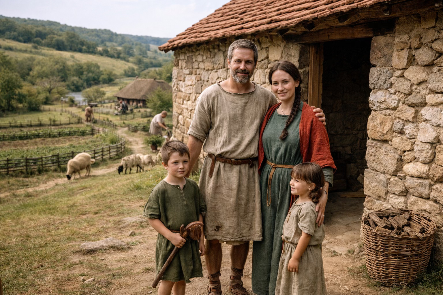
This is Sherborne’s immediate heritage. We stand today on the same place as this family did 1800 years ago. It’s ours to appreciate, protect, and understand. Do you feel connected with this family? You should!
