More Lodge Park Detective Work: Uncovering Another Lost Burial Mound
A New Discovery in Bridgeman's Plan?

[This piece continues the author's investigation into the layered history of Lodge Park's landscape, building on previous analysis which identified pre-1729 features on Bridgeman’s plan.
I appreciate that my obsession with the local historical landscape around Sherborne, Gloucestershire might bore some readers—please don't hesitate to cancel your subscription if this is getting overwhelming. However, the mixture of prehistoric, Roman, Anglo-Saxon, medieval, 17th- and 18th-century landscape features around Sherborne is quite remarkable, and continued analysis keeps throwing up intriguing insights—or at the very least, remarkable coincidences.
What follows is a little detective work. In my last post, I showed that Charles Bridgeman's c.1729 plan for his design alterations to Lodge Park revealed not only his intended changes but also marked some pre-existing features. I drew attention to the pool, hexagon, and octagon—all apparently pre-existing features in 1729.
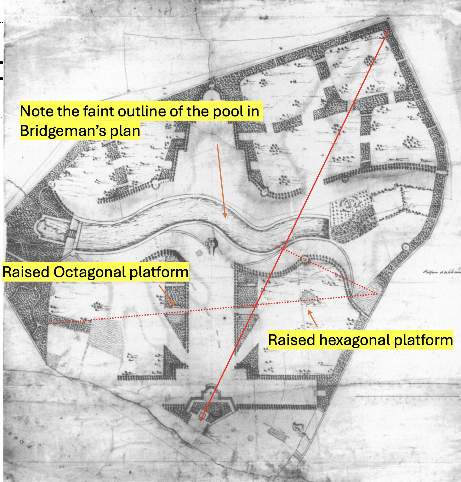
Returning to examine this plan for more possible pre-existing, forgotten features, I've found a very intriguing one. In this close-up view of the wooded area behind the grandstand, there's a shaded area suggesting a significant bump in the ground.
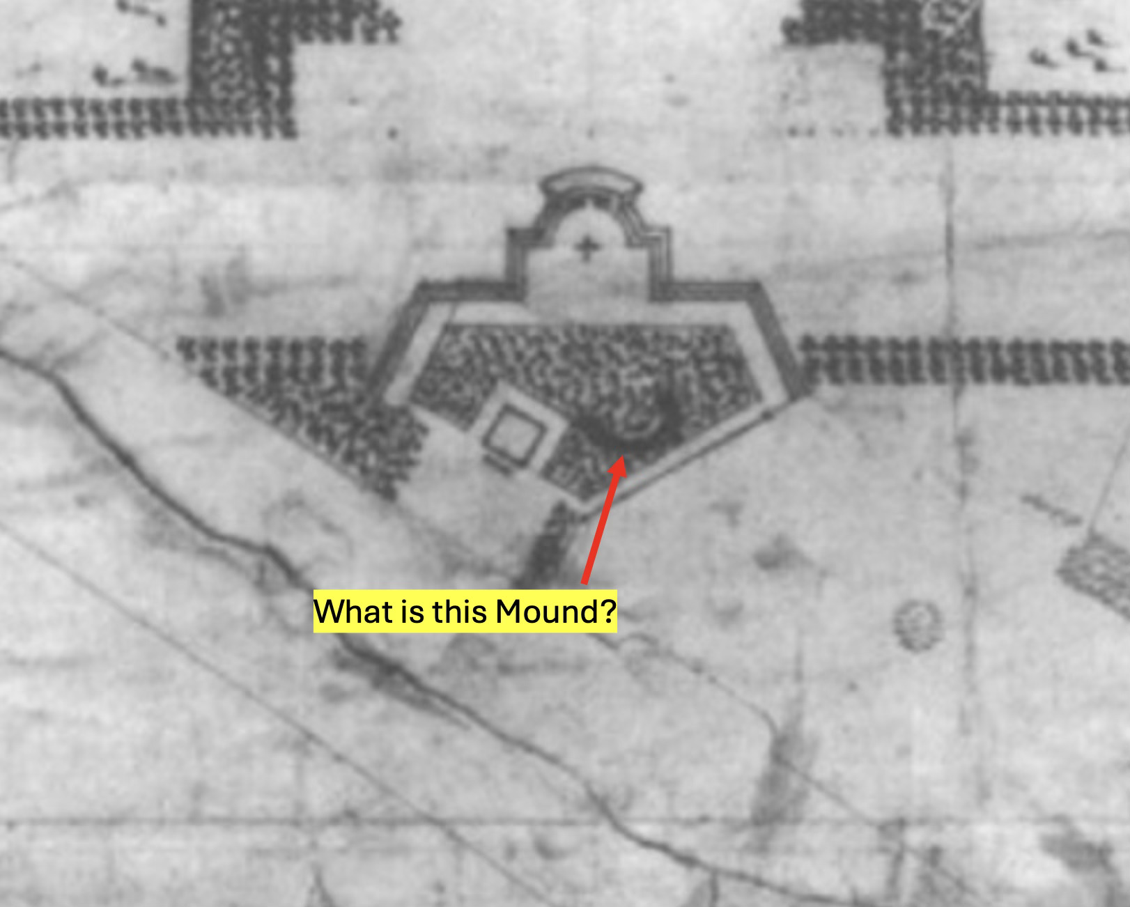
What could it be? Here's my theory:
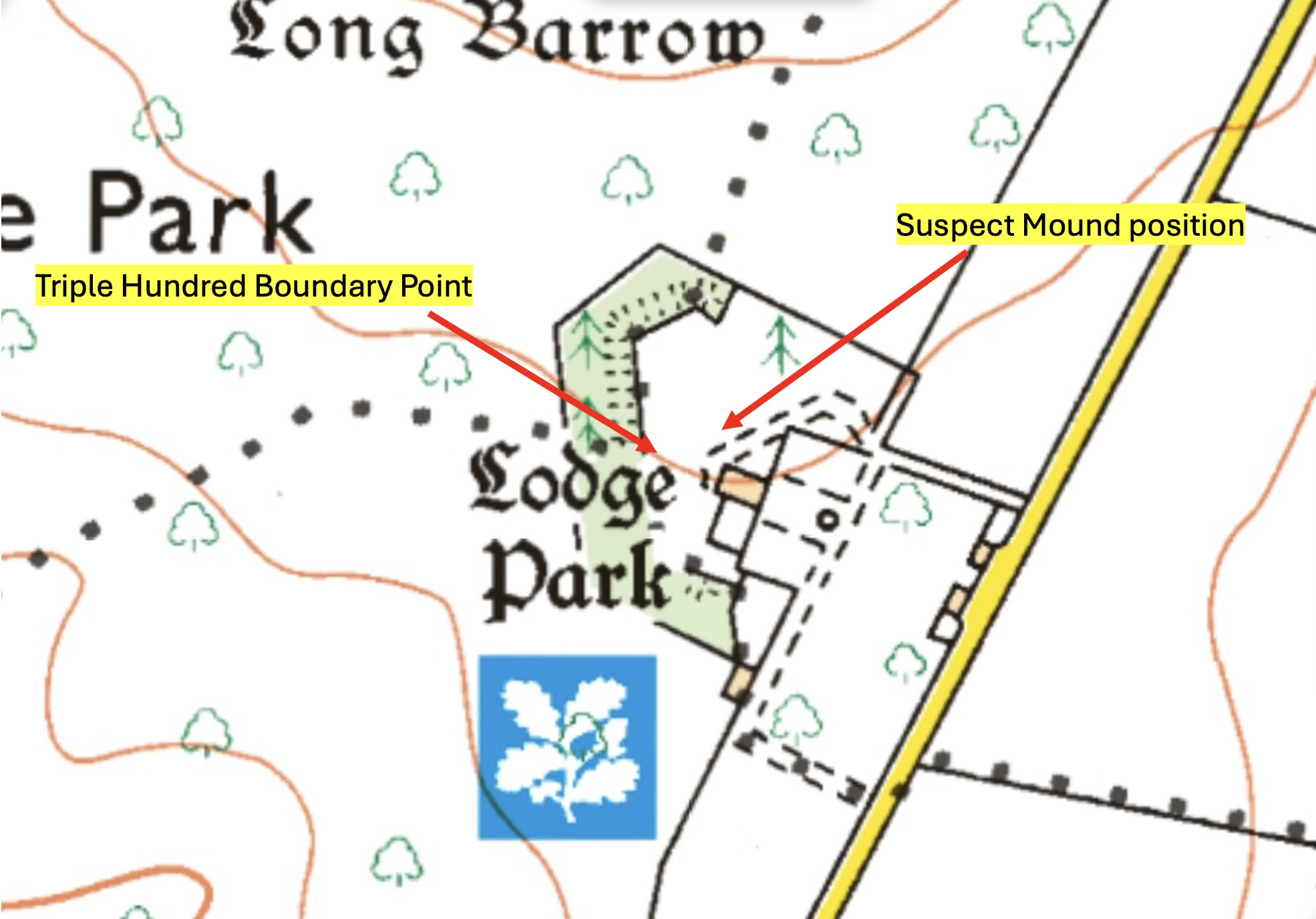
The Triple Hundred Boundary Connection
This location sits about 50 yards from the Grandstand and very close to the "triple hundred" boundary—the intersection of three Anglo-Saxon administrative areas. The Anglo-Saxons frequently used pre-existing features, particularly burial mounds, to define their boundaries, especially at the junction of several hundreds. We should almost expect a prehistoric feature at this point or very nearby.
Given the shape of this apparent mound, its position, and our knowledge of several other prehistoric mounds in the locale, I wonder if this could have been another burial mound?
Documentary Evidence: The 1741 Account Entry
Several pieces of supporting evidence suggest this may have been a burial mound removed from the garden area in 1741. At this point, there's a telling entry in the Dutton estate accounts. This area was being developed as a garden in the 1730s and 1740s to meet at least part of Bridgeman's plan.
This entry jumps out:
"Removing ye Mount in my New Park and carrying it into the Quar pits by the Great."
That could be a reference to the mound visible to Bridgeman in 1729 and marked on his plan.
A Conjectural Timeline
Let me propose the following sequence of events:
Pre-History - A Burial mound constructed here, with good views of the surrounding countryside.
Anglo-Saxon Era - The mound used as a delineating point in defining the meeting point of three “hundreds”, the Anglo Saxon administrative area.
Elizabethan Era (late 16th century): Deer coursing and deer hunting were popular sports. Contemporary documents detail that "standings" were often built to enable spectators to view both deer coursing and shooting. It would make sense to use a standing with good views of the countryside, utilising a pre-existing earth mound as a natural platform. The mound used here was the mound used as a key point on Anglo Saxons administrative boundaries.
Early 17th century (1620s): A wealthy landowner might build a grandstand adjacent to the earthen mound stand to entertain the gentry while relegating common folk to the old mound. This might explain the Grandstand's specific location. The area to the west of these two features could even be an area where deer were chased to, then shot.
1740s: The mound no longer fitted the ornate garden being created here, so it was literally shovelled away. In recent days, the Sherborne Archives showed me evidence that in 1745 the Dutton family even considered demolishing the Grandstand at this time. The archive team are doing some very interesting research into the deer coursing, hunting and horse racing of the Duttons and should be commended for the material they are finding.
Astronomical Alignments: More Than Coincidence?
There are other peculiar characteristics of this purported "mound" worth considering:
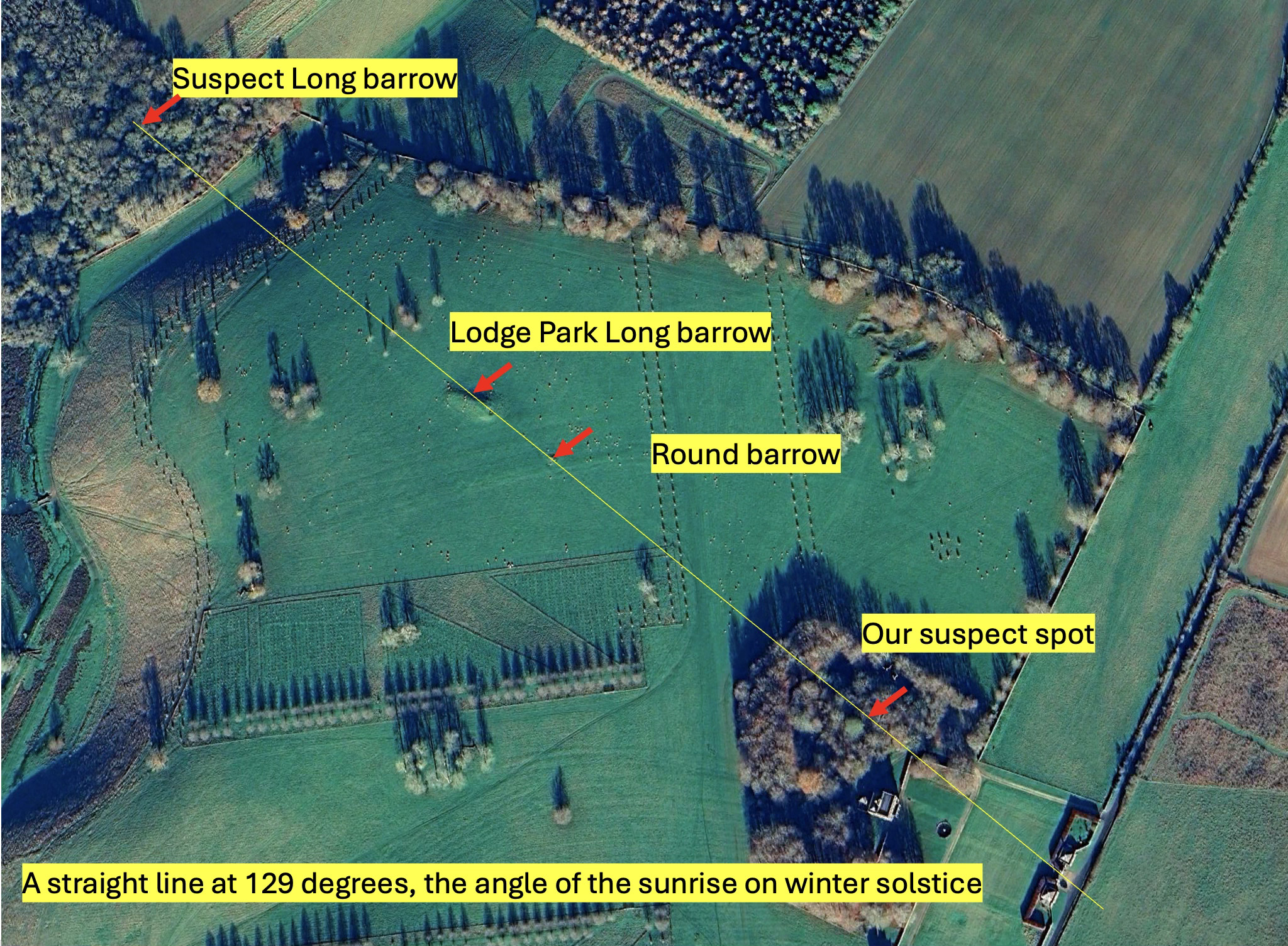
We've seen that there are quite a few Neolithic and Bronze Age mounds in the locale. Dozens. In earlier posts, I've shown that many seem aligned to the solstices. Let's plot some solstice lines on this point:
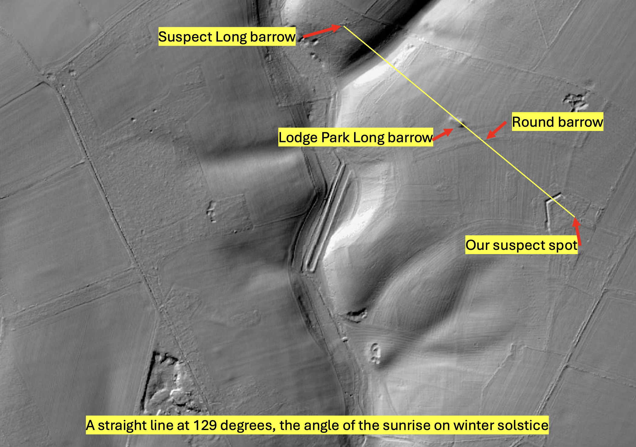
Winter Solstice Alignment: The winter solstice sunrise, when viewed from the northwest, creates a direct alignment through this site with the Sally Coppice suspect long barrow, the Lodge Park long barrow, and the round barrow just southeast of the long barrow—all in a perfectly straight line. That would be quite a coincidence.
And here’s the same on LIDAR:
Summer Solstice Alignment: Drawing the summer solstice line through this point reveals another direct alignment with the Woeful Lake Bronze Age round barrow, continuing to the suspect mound we've previously discussed (now containing an ice house at the southern end of Sherborne House's pleasure ground). That ice house sits on another alignment too.
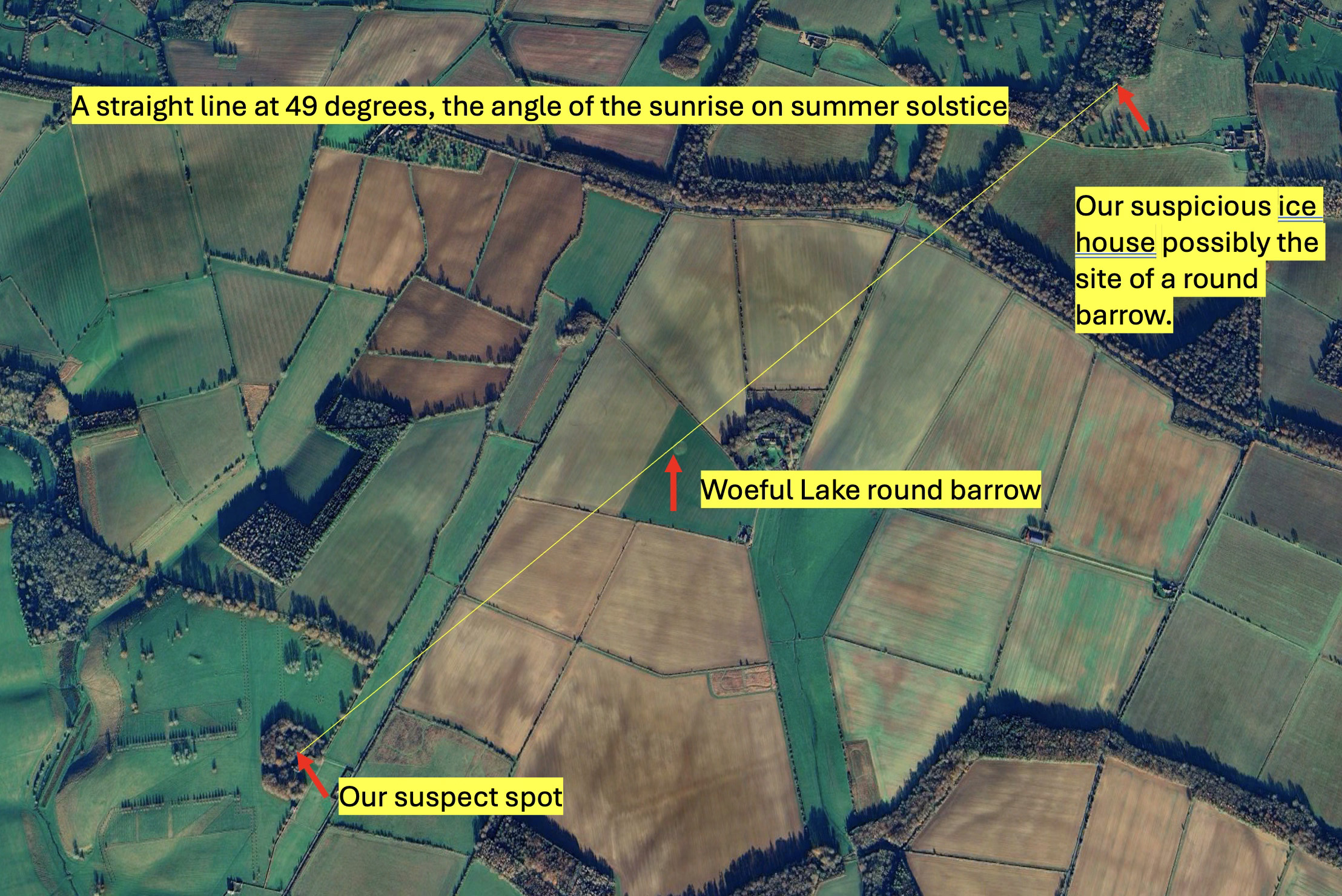
Coincidence again? They all begin to add up, don't they? These angles of 49 degrees and 129 degrees the summer and winter solstice angles seem favoured. I think it’s possible that these alignments of the burial mounds (of which there are more than we realise), criss-cross this landscape in a grand scheme. But that’s probably pushing things too imaginatively - for now. If I put them all on the map for you you’d start to freak out (I do!) .
Again if this is a bit too esoteric for you, I won’t be offended if you ignore it. But let me know if it is interesting, or press the “like” button for those of you who are subscribed via Substack. ;-). I should also acknowledge the help of the Gloucestershire County Archaeology Team for their help with a GIS tool to analyse solstice alignments.
