Ridges and Furrows and Barrows
A zig zagged theoretical perambulation to possible pre-historic sites.

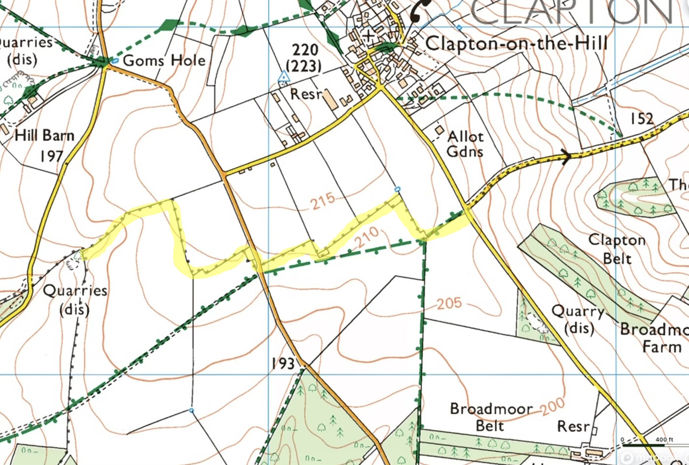
I'm returning to my investigation of Sherborne parish's northern boundary, particularly those intriguing "zig-zag" sections I discussed in previous posts. Here’s a reminder of the boundary with the zig-zags highlighted.
Previous Theory: Ancient Barrows
Initially, I speculated these zig-zags might reveal forgotten Long Barrows. As a reminder Long Barrows are neolithic burial mounds, maybe 5500 years old. They represent the first permanent croupiers of our landscape here in Sherborne. My speculation was based on:
- Parish boundaries often following Anglo-Saxon charters. I surmise that there was an Anglo Saxon charter for Sherborne c811 AD (long lost) and that it was pretty much where today’s parish boundary is. My last post showed the parish boundary extant in 1824.
- These charters using prominent landmarks as boundary markers
- The boundary running along a false crest (frequently used for Long Barrow locations)
- The size and orientation of some of the small enclosed copses at some corners being generally of the right size and orientation to “fit” a Long Barrow which would have been prominent landmarks to the Anglo Saxons. Many have been eroded or ploughed out over the centuries, and this part of the Cotswolds is an area where Long Barrows are surprisingly prevalent.
A New Explanation: Medieval Field Patterns
At a recent Gloucestershire Local History Association meeting, Dr. Simon Draper offered a compelling alternative explanation for these "dog-legged" boundaries.
Those familiar with Sherborne's landscape will recognize the "ridge and furrow" patterns in many fields—remnants of medieval plowing techniques. These patterns relate to:
- Medieval agricultural strip farming methods
- Physical constraints of oxen-pulled plows
- Adjacent fields often having perpendicular furrow orientations
When medieval clerks established parish boundaries, they followed practical, pragmatic routes across the landscape. They naturally traced the edges of existing field patterns, creating these characteristic right-angled turns where field orientations changed. Here’s a LIDAR image of the area around Waterloo Bridge towards the West of Sherborne, unploughed for centuries now, clearly showing detailed “ridge and furrow” lines. Note how these ridge and furrows go NS but some are aligned EW.
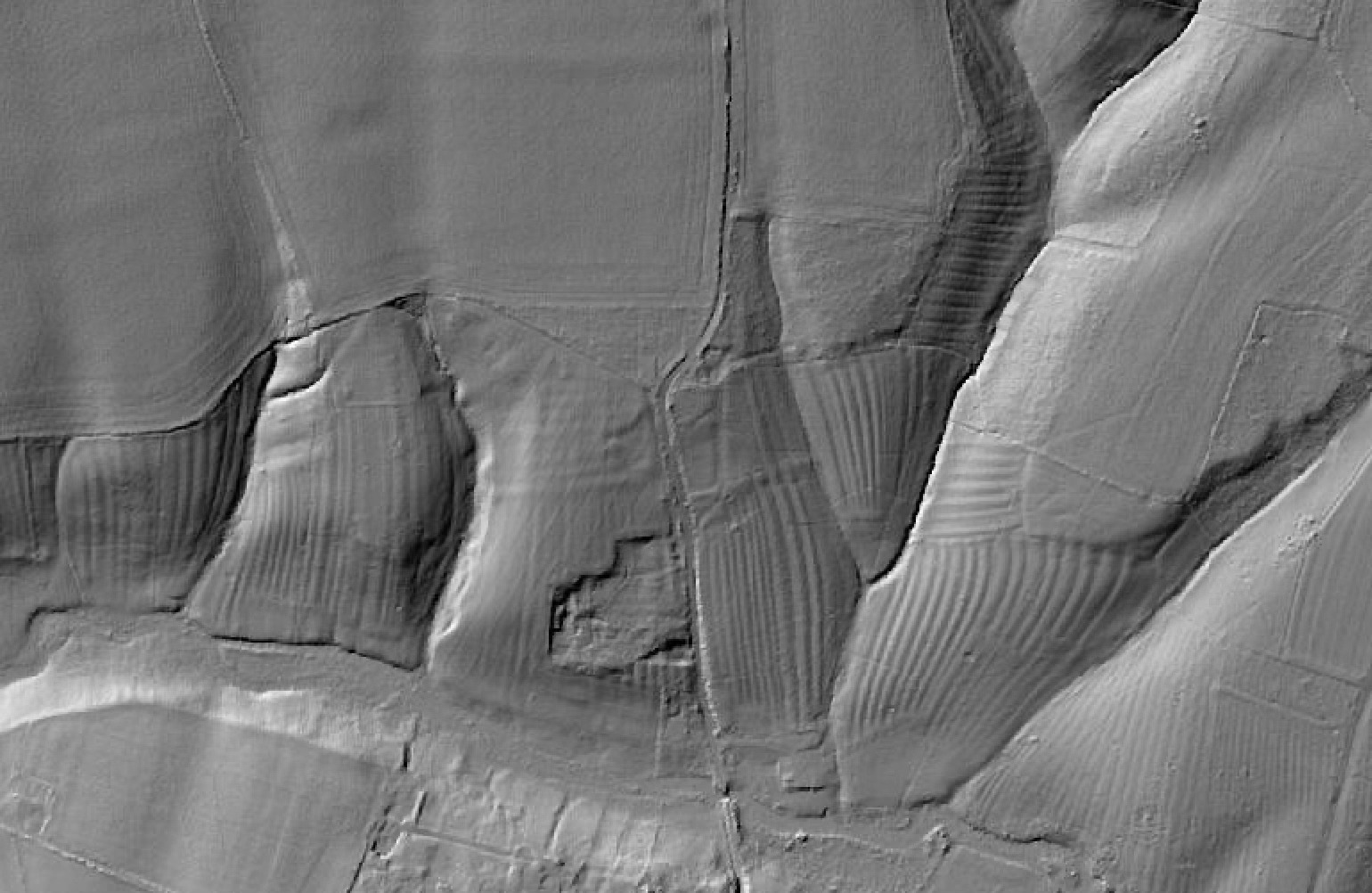
Note too how those fields which have seen the modern plough have been totally flattened.
Now, if I were to create an artificial 21st century boundary based on the principle of not cutting off a farmers ridge and furrow it might look like this:
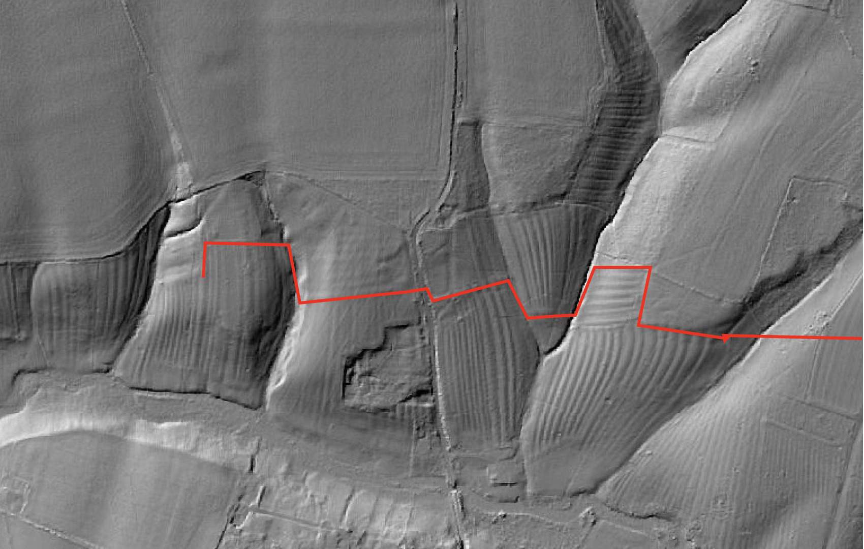
That seems not too unlike our Northern boundary in general terms. I cannot but help dream about the effort put into creating these ridge and furrows. Century after century of Piers Ploughman trudging through the mud, using skill and muscle to control one, two or four oxen, up and down, year after year. Truly shaping the landscape.
How Ridge and Furrow Field Patterns Were Formed
Ridge and furrow patterns are distinctive undulations in the landscape that represent one of the most visible remnants of medieval agriculture in Britain. Here's how and why they formed:
The Medieval Open Field System
Ridge and furrow patterns emerged from the open field farming system used throughout the medieval period (roughly 9th-15th centuries). Under this system:
- Villages were surrounded by large, communal fields divided into strips
- Each peasant family farmed several scattered strips rather than a single consolidated plot
- These strips were typically long and narrow (often 220 yards by 22 yards)
Formation Process
The ridge and furrow pattern formed through repeated plowing over centuries:
- Plough Technology: The heavy mouldboard plough was pulled by a team of oxen (later horses)
- Ploughing Method: Fields were ploughed in a clockwise spiral pattern, with soil always turned inward toward the centre of the strip
- Soil Movement: This consistent inward turning gradually moved soil from the edges toward the centre of each strip
- Accumulation Over Time: After hundreds of years of this practice, the centre of each strip became elevated (the ridge) while the boundaries between strips became depressed (the furrow)
Practical Purposes
These patterns weren't just an accidental byproduct—they served several important agricultural functions:
- Drainage: In heavy clay soils, the ridges improved drainage by raising crops above waterlogged ground
- Soil Warming: The raised ridges captured more sunlight, warming the soil earlier in spring
- Boundary Marking: The furrows clearly marked the boundaries between different farmers' strips
- Increased Surface Area: The undulating surface actually increased the cultivatable area
Preservation
These patterns have survived in many places because:
- They were difficult to level even with modern machinery - but the flat fields elsewhere in Sherborne show it was done. Modern tractors and ploughs will flatten a long barrow but a medieval plough would avoid these places, leaving them as isolated islands amongst the fields.
- Many were preserved when medieval fields were converted to pasture during the enclosure period
- Once under pasture, the patterns became "fossilized" in the landscape
This is why these ancient agricultural patterns still influence modern boundaries, as in Sherborne parish.
Reassessing the Evidence
This explanation offered by Dr Larder effectively accounts for many of the dog-legs along Sherborne's northern boundary in particular those which are of “field size” . The medieval agricultural landscape has left its imprint on our modern parish borders.
However, this doesn't entirely eliminate my Long Barrow theory. The smaller dog legs enclosing small copses is harder to attribute to ridge and furrow development. They are simply too small. These enclosed areas, on corners, are barely 30m long and yet we know that the ridge and furrows elsewhere in the parish are typically 100 - 200m long. The dog leg area I identified recently on the western boundary , that also has an apparent mound alongside it is too small and in the wrong place for a ridge and furrow defined change in direction. To try and explain more clearly with a graphic illustration:
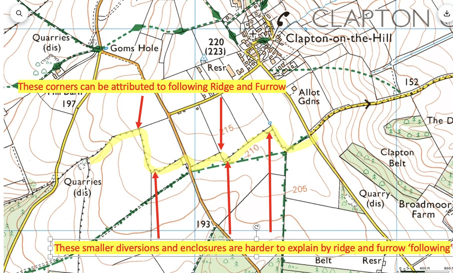
These small specific enclosed areas remain worthy of further investigation.
Conclusion
Dr. Draper's explanation provides a convincing rationale for a good proportion of our boundary irregularities. But significant questions remain about the smaller enclosed doglegs. While perhaps less exciting than discovering a series of ancient burial sites, the role of ridge and furrow in defining our heritage landscape deepens our understanding. I also think the “corners” of the parish, where the boundary abuts another parish are worthy of more investigation as possible sites of what the Anglo-Saxons would have regarded as a prominent landmark.
(So I'm still barrow hunting!)
