Sherborne's 125m spring line
Water everywhere
Firstly, apologies for being quiet these last couple of weeks. In old-fashioned terms I have been “indisposed” .
In a post a couple of weeks ago I went a little off piste thinking about a particular spring, where water flows magically from the ground. For this post I’m returning to my map reading/engineering skill-set to examine something interesting about just a few of the springs in the parish that have something in common. Sherbrooke as a village has loads of springs and is probably one of the reasons the village exists here. This is just a small proportion of them.
Sherborne sits in an interesting place geologically. I’m simplifying this somewhat but the local landscape consists of various layers, the important ones being fine clay and “oolitic” limestone. There are other odd layers in places - Sandy Hill really is a pile of sand. Much of the local clay is very fine, so much so it can be described as “Fullers Earth”. This Fullers Earth clay has given us some interesting history, one of the first few fulling mills in the country, c1200, was between Haycroft and Waterloo bridge. Here was where wool was treated with water and Fullers Earth to make felt, squeezed by wooden hammers turned by a water wheel. The same Fullers Earth clay was dug up just North of Waterloo Bridge for Sherborne’s very own brick and tile factory 120 years ago. The alkali nature of Fullers Earth cleans wool, removes lanolin, and shrinks the material, making wool more dense.
It is the combined nature of the properties of limestone and the fine clay that gives rise to the phenomena of springs on Sherborne. In limestone, water moves primarily through fractures and solutionally enlarged openings, while clay layers tend to be less permeable. Water finds its way through limestone over time. But fine clay is pretty impenetrable to water. If you have a layer of limestone above a layer of clay , the water cant pass through to clay and if the boundary is on the edge of a hillside the water will simply be at the surface - a spring. These sandwich layers are a bit complex with the folds on the landscape but sometimes they are stark, and if you know what to look for they are pretty obvious. Given my prrvious post on the “liminal” nature of Sherborne’s landscape this is another “threshold” - the threshold between limestone and clay and their different properties affecting water.
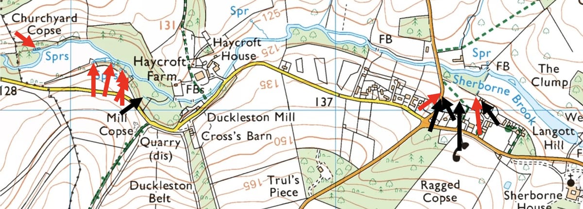
The sandwich layers I’m going to show you now I call the 125m spring line. Look at the attached map. I have put red arrows where the Ordnance Survey have included a description of springs and black arrows where other springs on this line exist. In ordnance survey maps they are annotated as “Spr” and in some “issuances”. Note all these arrows lie on the 125m contour line - the junction between limestone and clay.
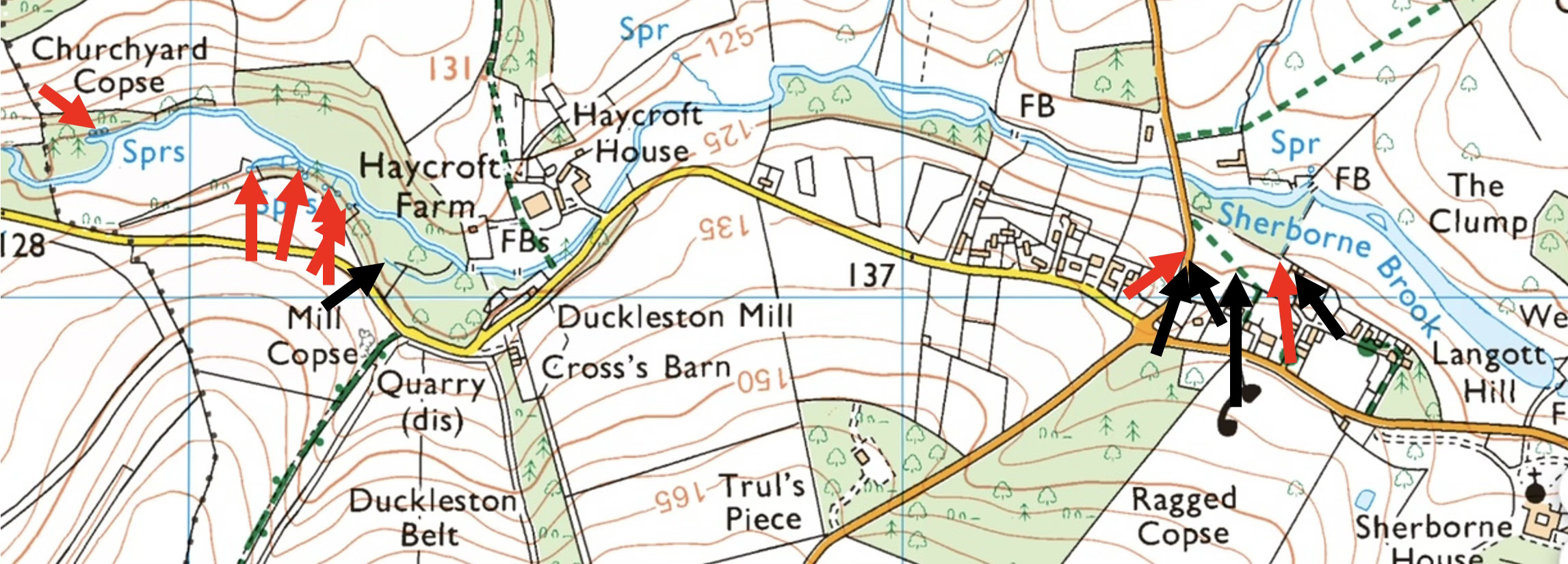
You will note there are three arrows on the road, just south of Waterloo Bridge. There is an old well in the western wall, covered with a few concrete beams, that was a well known village well - you can hear the water at this point if you stand quietly and it runs down beside the road. This is marked on some large scale OS maps as an “issuance”. And then in the middle of the road, water has been welling up from under the tarmac for the past 3 or 4 years. This demonstrates that the limestone’s slow dissolution can cause springs to appear as if from nowhere. The extreme right hand arrow is a building in the garden of Elm tree cottage, clearly built around the spring as a well. I have a theory I’m working that this was an important village well and possibly the mysterious “dragon well” or “swan well” mentioned in the early enclosure acts around Sherborne, but more research work is needed to confirm this.
To prehistoric man these might appear magical. Similarly sometimes an underground collapse will divert water from a reliable spring to one that no longer flows. Springs can run forever, uninterrupted or vary over a season, depending on the geology. They are in some ways vague things but in others intriguingly predictable. One can see the importance of a spring to prehistoric settlements almost all of which have springs nearby, usually just down slope, and the whole of Sherborne pretty much fits this characterisation. These springs are an important facet of our community heritage. Sherborne is full of adaptations of these springs, either turned into standing pumps, or ram pumps to move the water elsewhere. Alas they have all been abandoned and are no longer functional or have been concreted over. It’s a real shame, because we should be proud of these places, their function, their importance, their utility to the community and perhaps too the magical feeling one feels from observing water mysteriously appear from another world. At the very least I think we should mark the importance of the village wells and pumps perhaps with a little plaque. In the old days there’s wasn’t “WhatsApp” to provide news and gossip, one went to the village pump with a bucket and got water and information equally. Sherborne Archives have many details of these places and recognise their importance. We should cherish this history.
