Smallpox in Sherborne, Sheep houses and dating of the footbridge
Historical nuggets of gold falling out of the 1711/1712 notebook
I continue to be thrilled by the discovery by Diane Lovell of John Dutton’s notebook and accounts from 1711/1712. Clearly a systematic analysis of these remarkable records is needed but in the meantime I can’t but help to dive in on random pages.
A sleepless night last night took me to three pages at random, and within those three pages here’s three of examples of entries which give us marvellous historic insight.
At this entry here we see that John Dutton paid a significant sum of money for a doctor to come and treat him. His ailment…? SMALLPOX!
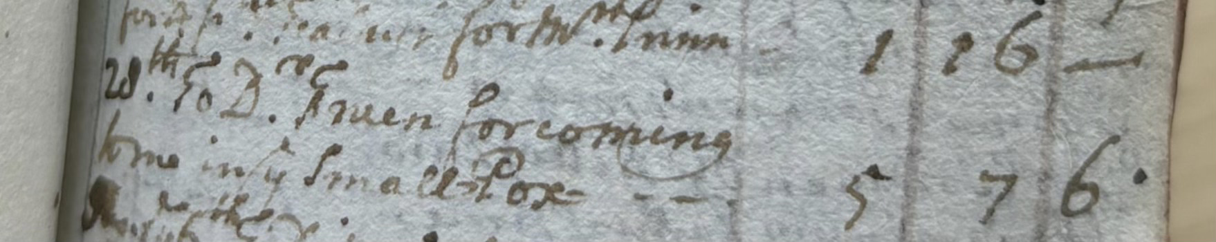
“ 20th (December 1711). To Dr Truern for coming to me in the SmallPox £5.7.6”
I was shocked so did some reading around. It seems that smallpox was not at all unusual in this time. It had a lethality of 30%, (less than I had thought) with some victims only displaying mild symptoms. I’m sure others in Sherborne in the early 1700s also got smallpox but here John Dutton himself was forking out a considerable sum for treatment. That’s fascinating isn’t it?
The next excerpt helps us understand some local nomenclature. Today in the parkland opposite the village (then called Home Park) stands what is known now as the Sheafhouse. This structure was built in the early 1800s, but on the site of an earlier structure. Over the years there has been some discussion about the name “Sheafhouse”. Perhaps it was used to store sheafs of corn or wheat. Perhaps the name evolved from “Shear house” i.e. the place that sheep were sheared. Perhaps it was “Sheep house”. Now, John Dutton, writing on the 4th February 1713, gives us the answer:
“To Leech for work at the Sheephouse in the Home Park in 1711, 8 shillings and 2 pence.”
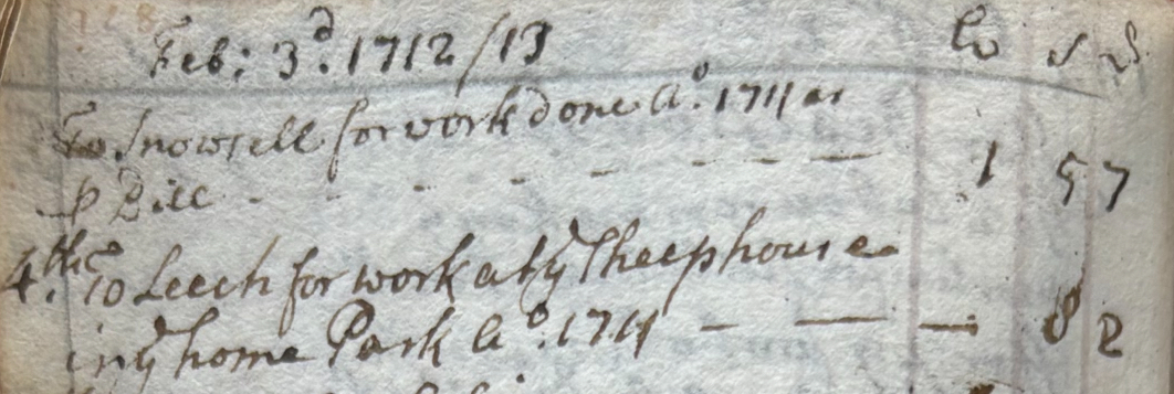
I’m learning the script quickly. What at first appears to a modern reader in the script as a “y” letter with a squiggle above it is actually the word “the”. In 1713 the letter “thorn” (which makes the “th” sound which never made the transition to print) was written in this way, with the squiggle above being an e. This is the misinterpretation that leads to “ye olde tea shoppe”. For those using a pen in 1713 “ye” was very definitely the definite article “THE”.
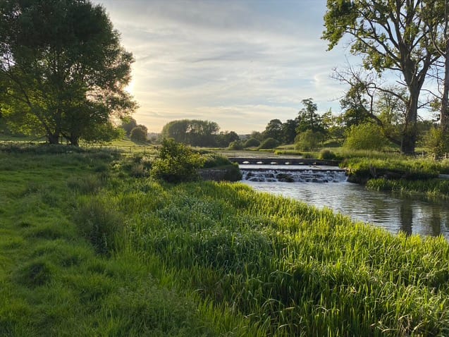
Finally, and somewhat of the moment, is an important piece of a jigsaw puzzle. For a while now I have been wrestling to understand where the part of the local estate called “Middleham” was. A “ham” can be taken to mean a field, typically a pasture next to water. It appears in some early documents and indeed in the 1777 Enclosure Act, and seems to be a parcel of land near Home Park. In 1739/1740 there is reference in the accounts to “Middleham Wear” (sic). All this led me to suspect that Middleham may be the pasture that runs downhill from the village road to the Brook, in the middle of the village. It led me to suspect that the weir and sluice seen in Kip’s 1709 drawing was this “Middleham Wear” . As you know, I have dismissed the NT assertion that the weir wasn’t built until 1820 accordingly.
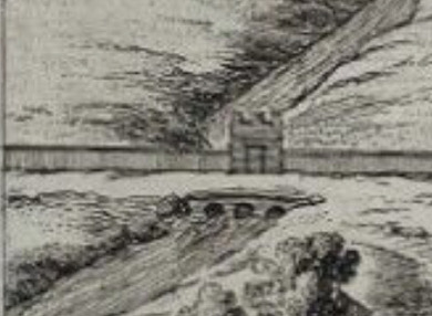
(Extract from the Kip drawing showing weir and sluice gate)
So until now we have known that Middleham was a field in Sherborne, somehow adjacent to “Home Park”. We know that a weir existed, associated with Middleham field in c1739. Now, in John. Dutton’s accounts from 1712, I come across this entry:
“To Tilling making an Archd Bridge at Middleham. £2.12.2”
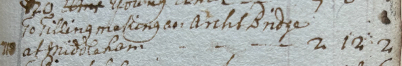
So to analyse this, we know it can’t be Waterloo Bridge, upstream (built c 1820) and Wadlandstone bridge - on the road the Clapton, downstream, was built at some time in the 19th C. The only logical location for this new bridge built in 1712 is right in the middle of the village, here
Here’s the HER record for this bridge. No date is given in the HER but now we have one.
So what does all this tell us?
- The field immediately south of the Brook between the Brook and the village was once called Middleham.
- Middleham weir and sluice existed before 1709. So there was a body of water (now called the Broadwater) here before 1709 (and could be much before). This reinforces my challenge to the NT’s dating and the somewhat casual dismissal of the importance of the Broadwater.
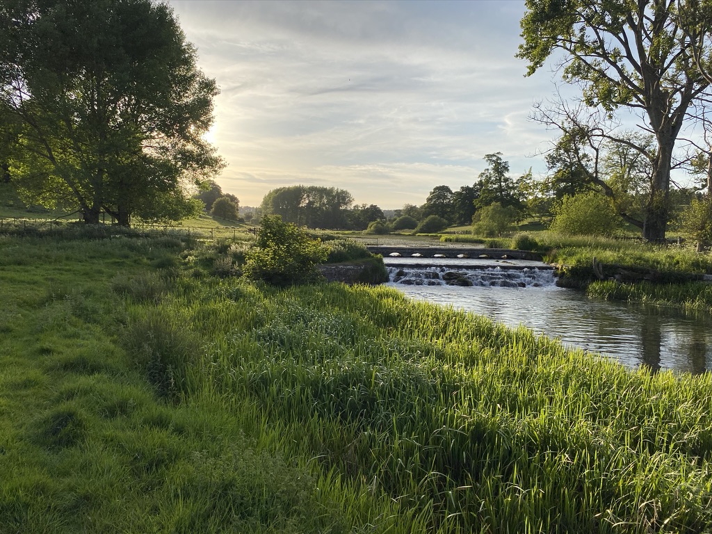
- An arched footbridge was built on top of the weir in 1712. That may have allowed the water level to be raised further at this point, creating a broader Broadwater. I’m speculating a little but I think it’s logical. The sluice remains today running through the weir and under the footbridge at a height lower than the gaps for the arches.
The structure around the weir here is more complex than it looks. The features include:
- A weir
- A sluice
- A fish trap sluice
- A footbridge with several arches
- A cobbled ford or “carriage splash” - quite the thing in the ;late 18th C
- A stepped cascade.
We shouldn’t assume that all these features were built at the same time. I have a suspicion that the stepped cascade was added in c1803, (another Diane Lovell-found source) and I’m working on that.
I imagine that a 1712-built arched masonry bridge should be listed Grade II at the drop of a hat. What do you think?
As an aside I’ve found the odd minor reference to the 1711/1712 accounts elsewhere in Historic Environment Records (HER) but none that give any suggestion of detailed analysis. Someone has found this little notebook before and not done much with it.
I hope you aren’t too bored with these historic nuggets. Turn my emails off if you are!
