Something special in Sherborne - Part 2
Is there a Celtic chieftain buried beneath our feet?
A Secret Hidden Beneath the Ground
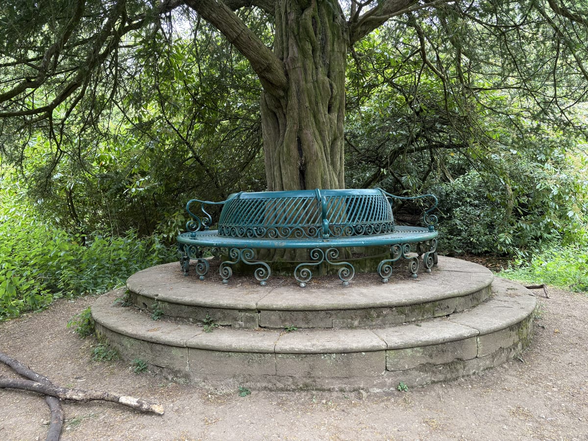
In my last post, I discussed the possibility that there is a 17th-century line of features, a spine, perhaps defining Sherborne Park, with the ribs hung off it perpendicularly to the various gates and doors. The new discovery there was this feature, a mound in the old Pleasure Gardens, south of Sherborne House.

But is there more here than meets the eye? Is there a secret hidden beneath the ground?
The mound, with the bench upon it, sits on high ground above the valley of the Sherborne Brook. Sitting there, if there were no trees surrounding it, would have provided a glorious view, up and down the valley. That got me thinking...
Could This Be a Burial Mound?
You will recall that in our other explorations we characterised the positions of various prehistoric burial mounds in the local area and used their characteristics to search for more – perhaps successfully. So I wondered, idly at first, if this could be a burial mound. Yes, that's a crazy idea. There are a lot of these prehistoric burial mounds in the general vicinity, and between here and Cirencester is an unusual density of known, recorded burial mounds, both Neolithic long barrows and Bronze Age round barrows, probably 15 or 20.
So, here we have:
- A mound in the general vicinity of others
- A mound roughly of the right size
- A mound roughly of the right shape
- A mound overlooking a valley
- A mound beside a quarry
That's quite a few ticks in boxes but not yet totally convincing. It's not adjacent to any later Anglo-Saxon boundary so that doesn't help. (You will recall that the Anglo-Saxons in the "dark ages" defined boundaries in part by listing existing prehistoric features.)
The Solstice Alignment Test
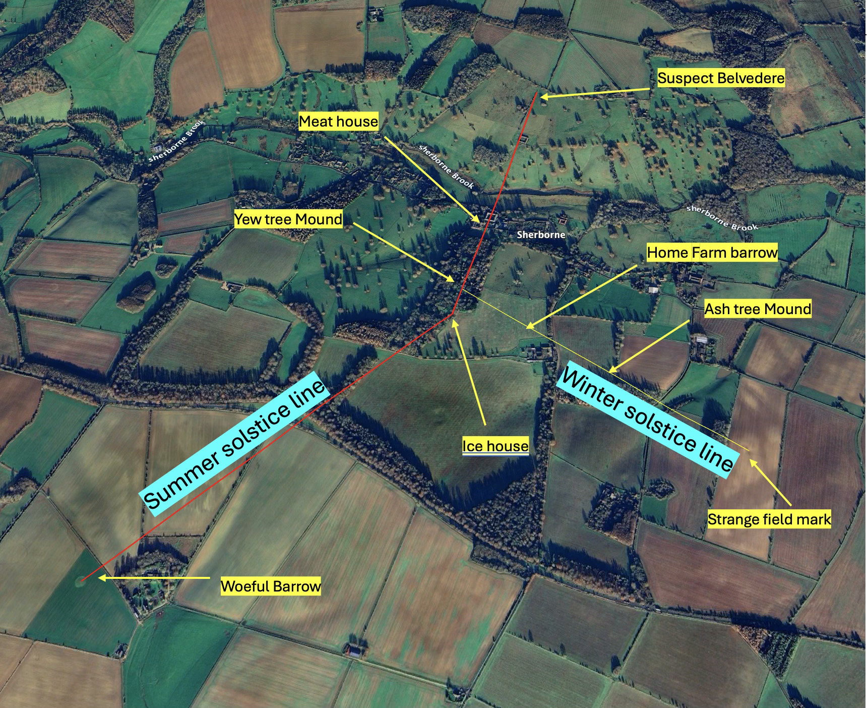
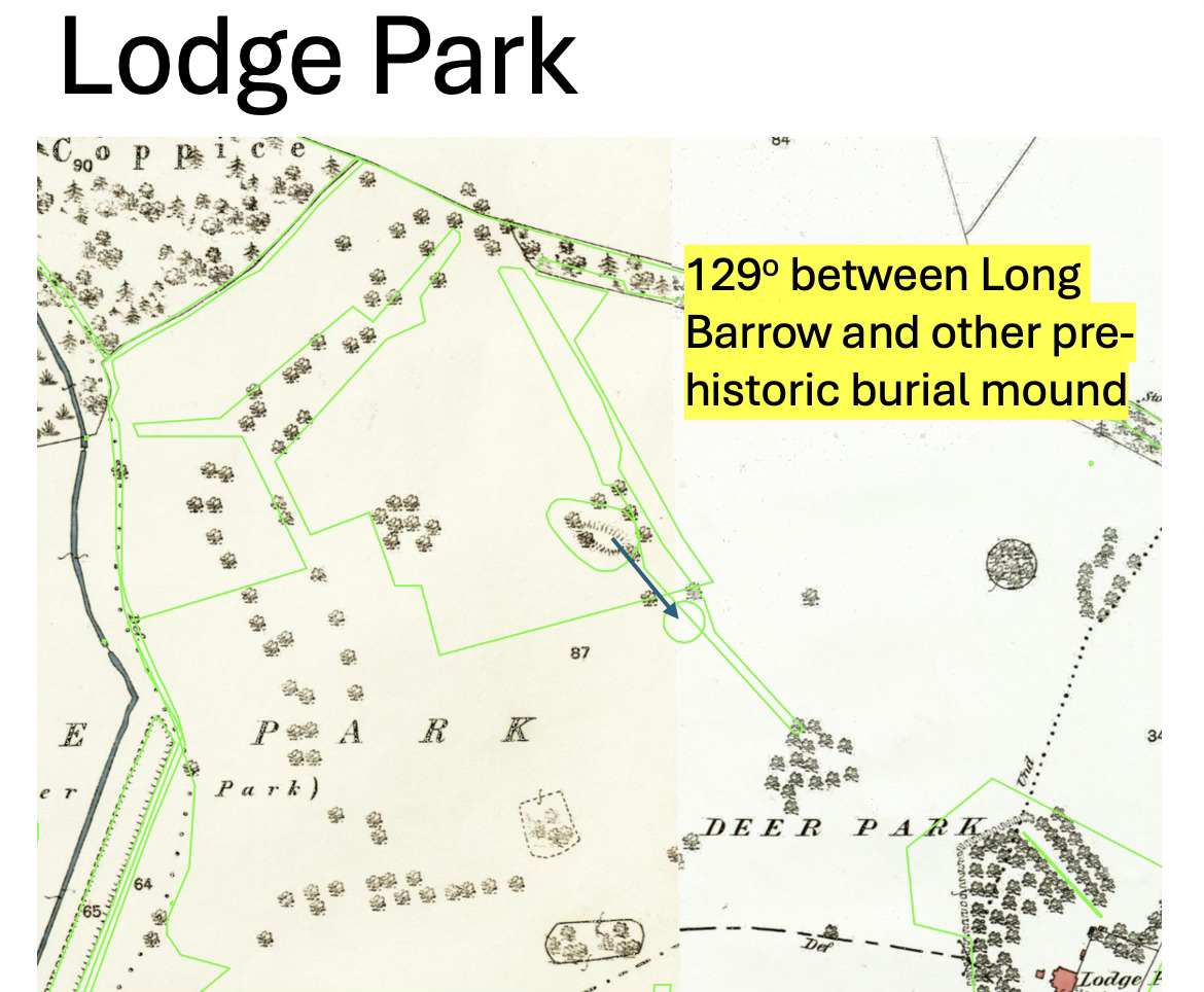
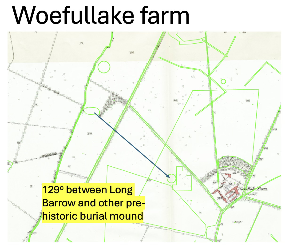
One of the most useful tools for considering burial mounds is solstitial alignments, and as you know, I've used this technique elsewhere in the area, discovering a second long barrow in Lodge Park, and another near Woeful Lake farm turn-off, on the old deer course. I wondered if doing something similar might help. To remind you, the "solstice alignment" is the line towards sunrise on midsummer's day (49 degrees) and midwinter's day (129 degrees).
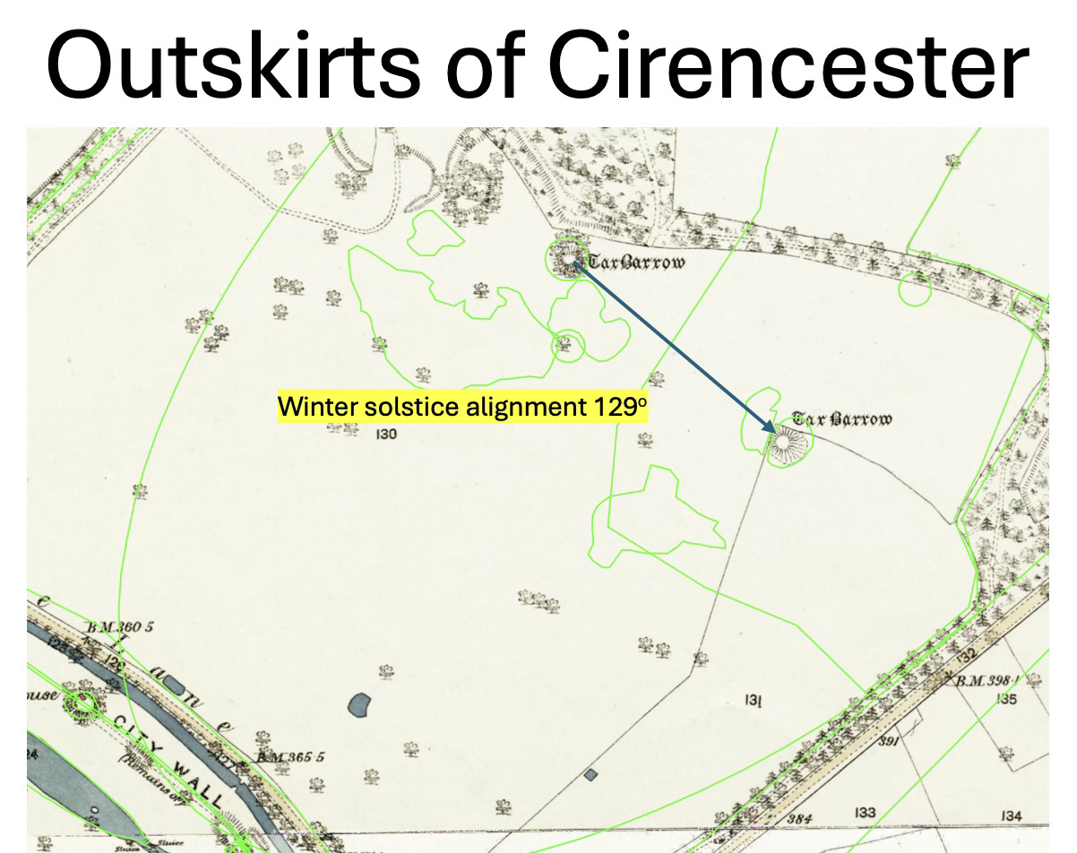
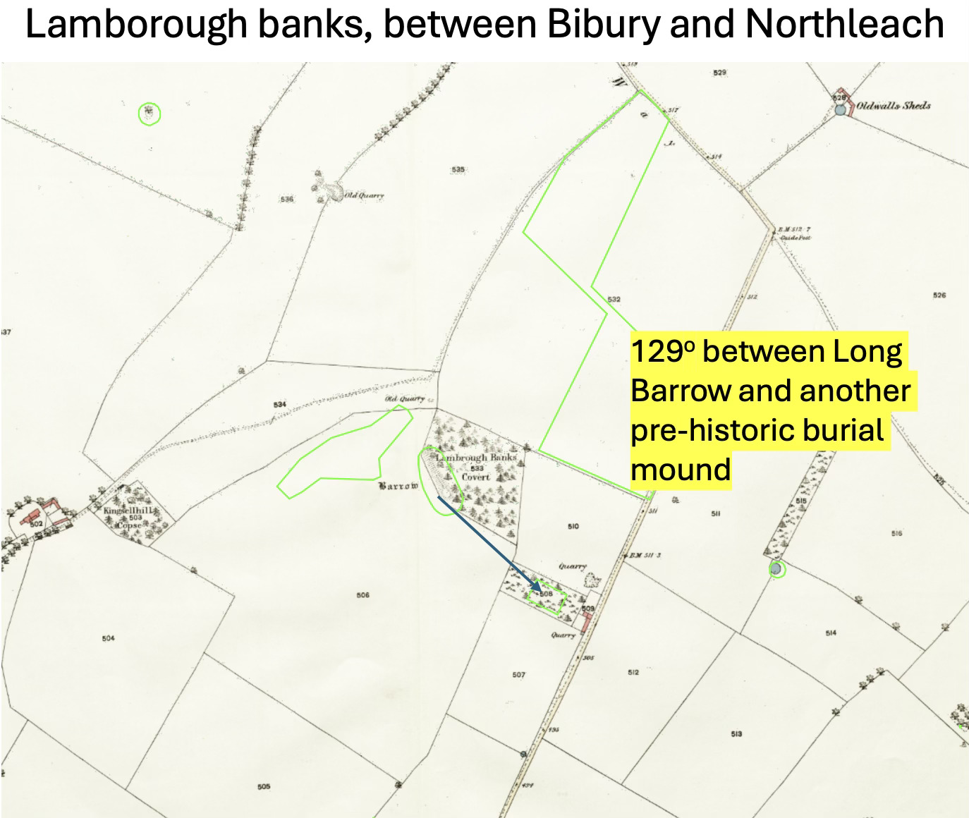
To show I'm not completely barking mad, I'd remind you that Stonehenge itself is aligned to the solstices, and then between Cirencester and here, we have the following:
The Tar Barrows, outside Cirencester with a 129-degree bearing between them, the angle of the winter solstice.
Lamborough Banks between Northleach and Bibury with a 129-degree alignment between the long barrow and another prehistoric feature.
Lodge Park, with a 129-degree angle between the long barrow and a round barrow 80m away.
Woeful Lake, with a 129-degree angle between the possible/likely long barrow and the known round barrow.
The point I’m making here, is that ancient burial mounds in the local area seem frequently to have an alignment to the solstices. So, I wondered if we might try that on the Yew Tree mound?
BINGO!
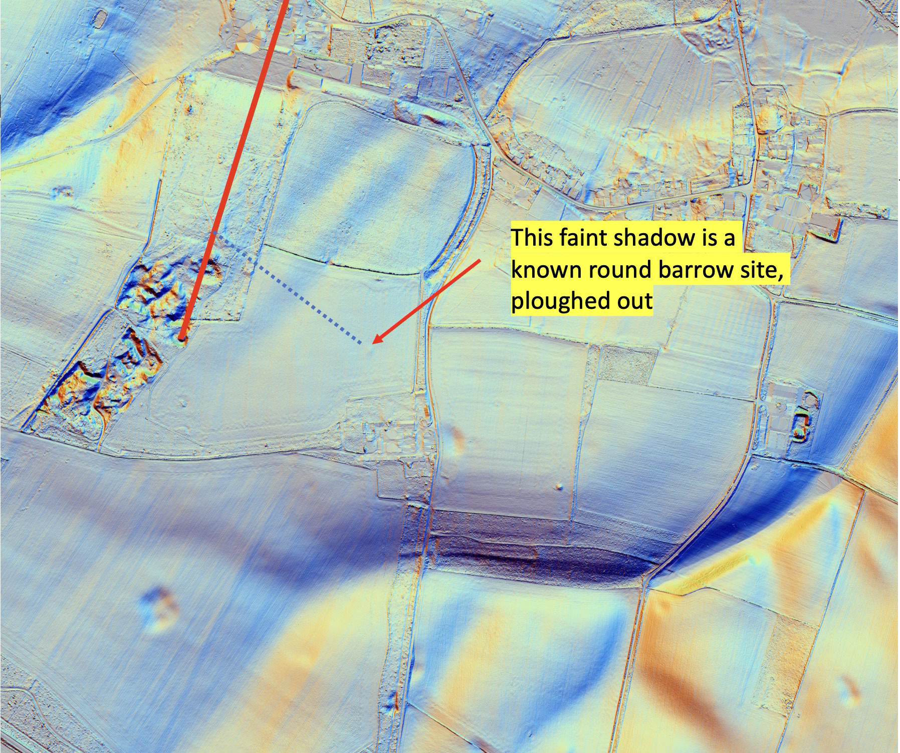
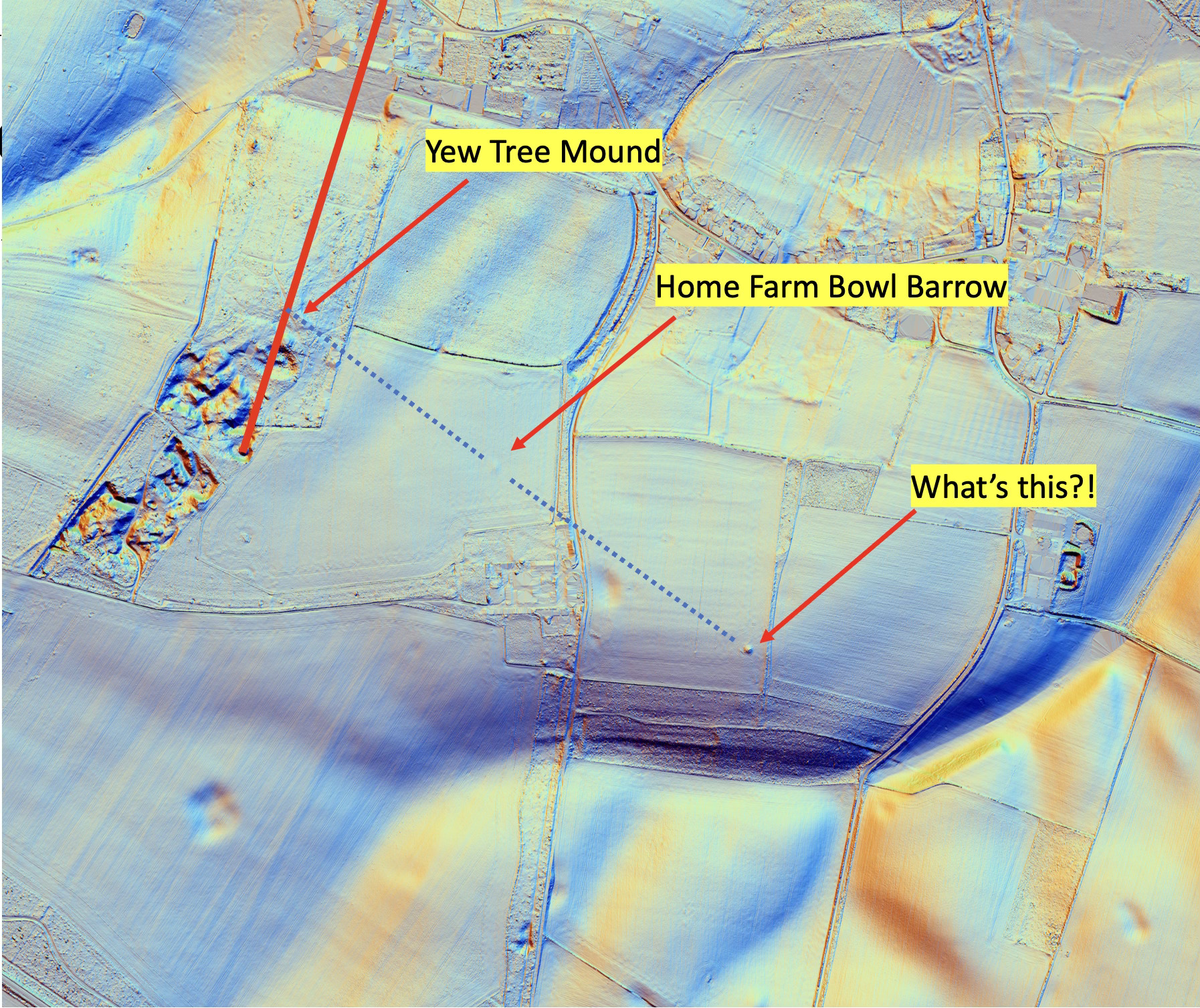
Here's a LIDAR image of the area. If I draw a 129-degree line from the yew tree mound, look – it coincides exactly with the known Bronze Age barrow northwest of Home Farm. (the link suggests there were other prehistoric features in this field but the location is unclear). The site is mostly ploughed out (no blame on the Limbriks!), but that site is a dead certainty and the winter solstice angle is dead on. From the Yew Tree mound, on midwinter's day, the sun would rise over the Home Farm mound. I think that's a huge tick in a box for our theory about the origins of the Yew Tree mound.
More Discoveries
But there's more. Here's the same LIDAR image but I’ve extended the 129 degree winter solstice line further to the southeast, what do we come to, as clear as day? Another mound! There is no HER (Historic Environment Record) associated with this patch of land – it's been ignored for centuries, and perhaps not ploughed for a number of reasons. But it too, I conjecture, is another round barrow, probably Bronze Age. That's two we have found and three in a row.
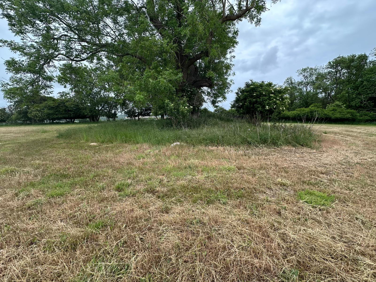
Here’s picture of this third possible barrow, which I’m calling Ash Tree Barrow:
Can we go any further? I have extended the line in LIDAR below across a couple more fields and a small plantation. But exactly on this line is a strange mark. I looked up the HER, and indeed there is an HER for this spot, suggesting it might have been a quarry of some sort. I'm going to suggest that it's looked at again – since it lies exactly on the alignment. As I have said before, I’m somewhat sceptical of some of the dating of features on HER.
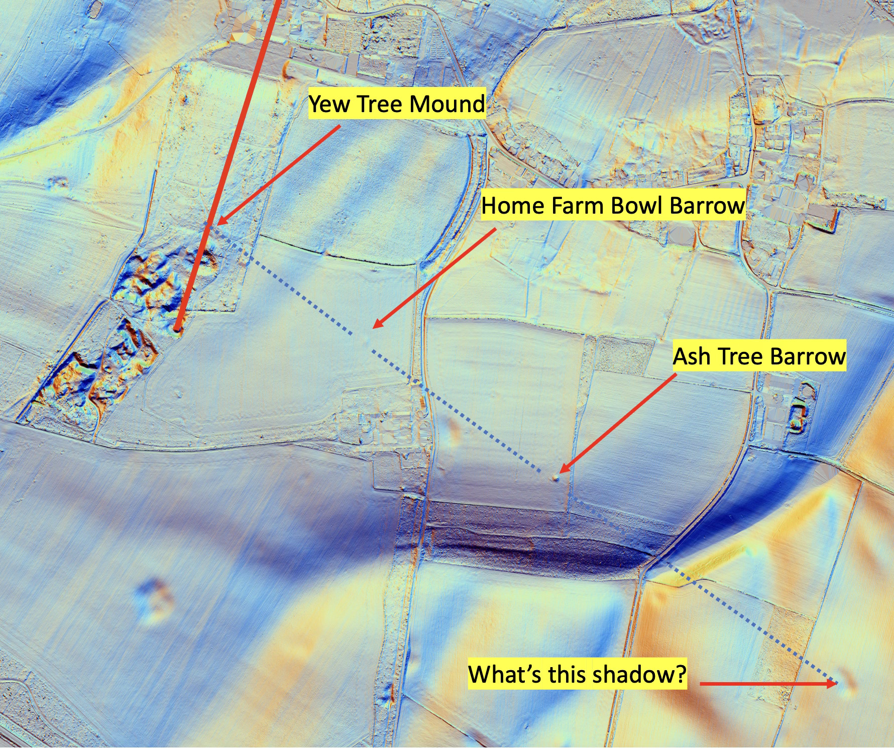
So I think this strongly suggests a line of features along the winter solstice line from the Yew Tree mound. I'm pretty certain that as far as Yew Tree Mound is concerned, with all the other characteristics, we have a strong candidate, very strong, for it being a Bronze Age burial mound.
What Does This Really Mean?
What does that mean? I think it means on one level that roughly 2500 BC a local chieftain was buried here. Bronze Age burial mounds typically contain a single male, assumed to be a local chieftain. But let's consider this a bit deeper – what does it really mean? I'm going to suggest that this site sends several messages to us, over four and a half thousand years, so read this intently!
- This man, buried in this mound, was important, probably the leader of those who lived in Sherborne. It existed for thousands of years before being incorporated into the “15ft” alignment when the parkland was created.
- It tells us there was indeed a community here, our predecessors, living in this valley, 4,500 years ago. That’s useful and exciting to know.
- It says the man was important, and his family and maybe his "tribe" needed or wanted to mark his grave
- It suggests, perhaps, he “owned” what could be seen from it. Lord of all he surveyed.
- It suggests that the mound marking his grave was meant to last for eternity, and the man buried within should be remembered and respected.
- Pure and simple, it is a heritage statement from our predecessors in Sherborne 4,500 years ago. we should be honoured they have sent us this message and prize the knowledge.
A Personal Challenge
I think that's wonderfully exciting. I'm by no means a historian, just a bloke who reads maps carefully, and by nature I'm not given to emotion. But I dare you to do something. This mound is only five minutes' walk from the centre of the village. Stroll up there from the door in the wall beside the old phone box. Follow your nose, you’ll find it. Sit on the bench. Take off your shoes and socks and let your bare feet touch the stone underneath. Imagine the dense trees are no longer there and you look out across the valley, over your friends and family living in Sherborne, over your own house. Or look to your right and it's midwinter dawn, the sun rising over another mound. Take a breath. And another. Can you feel the Celtic chieftain stir beneath your feet? Can you hear him whispering? He saying something to you, something he needs you to hear, a personal message. "This. is. MY. land."
History so often is written in books and is about places and people we don't know, so there’s a gap, a space between us and distant times. But this history, I suggest, is different. There is no barrier, no hurdle between the Celtic chieftain and you today. You live in the same place, you see the same sights, you breathe the same air and touch the same earth, and he is very much our predecessor in the village. Go there, to the yew tree, its trunk running deep into the mound, its roots entwined in the bones of our chief, through his ribs and amongst his fingers. He’s holding on, waiting to be rediscovered. Put your hand on the ground, or on the trunk of the tree behind the bench and sense him. It's real, it's here, and it's at the heart of our village. The chief, and his burial mound, are our heritage.
A Final Alignment
Finally – a throwaway line. We’ve had the maybe 17th C “15 foot” line and now we have a winter solstice line intersecting it. But…. If you draw a summer solstice line from the known round barrow near Woeful Lake, it runs directly, straight to the mound containing the ice house, just south of the yew tree mound.
Have you had enough of alignments yet?