The Peculiar Names of Local Burial Mounds
Have we mis-attributed the name of Wins Barrow?
As readers of this substack will know I have a fascination for the Neolithic Long Barrows and Bronze Age Round Barrows around Sherborne, Gloucestershire. These burial mounds were once much more prominent features but thousands of years of time and the plough have eroded some of them from memory. Most now are forgotten and nameless but I think we can be sure most once had “names”. In this post I’m going to look at one particular name that I think may be misattributed. I’ll explain my logic later in this post. I’m afraid what follows benefits those with some local knowledge of the geography.
But first, for context, here’s some of the burial mounds that I think we can name.
Remember these are just the burial mounds with Names. there are many more un-named.
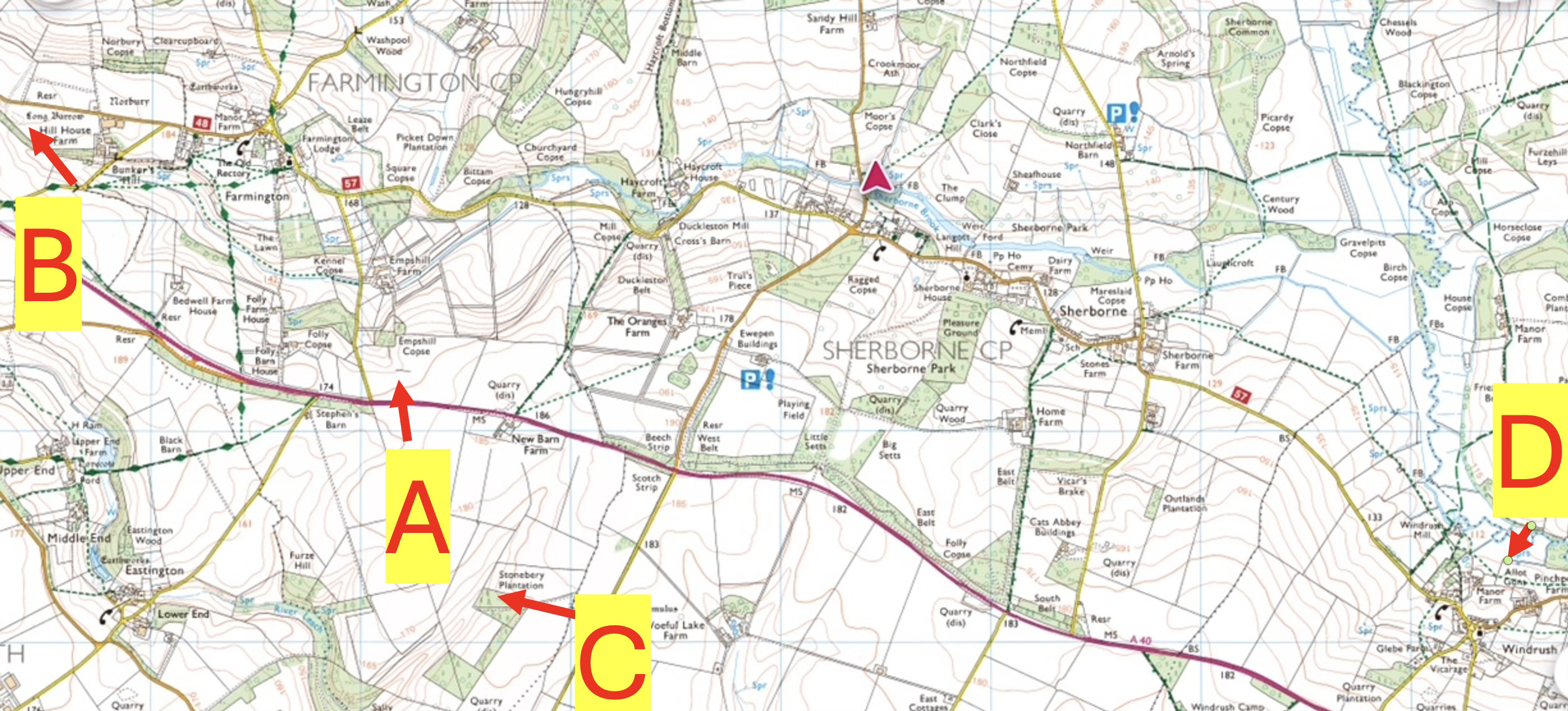
At Point A, just into Farmington is the remains of a Bronze Age round barrow called “Baubles Barrow”.
At Point B, in Farmington and within the bounds of an Iron Age encampment is Norbury barrow, after which the Iron Age enclosure is named, Norbury Barrow (the clue is in the suffix “bury” which refers to the “barrow” is Neolithic, so the Iron Age enclosure was built around it and takes its name. This is not that unusual. There are other Iron Age sites around the country which were established around older features.
At Point C is a small copse called Stoneberry. This is referred to in a c1700 document as Stone Burrow, and I’m certain is the site of a neolithic Long Barrow although very little remains today. Again the clue is the “berry/burrow/bury” suffix.
At Point D in Windrush to the East is a field called Nosebery and readers will recall we have identified a likely Long Barrow here on promontory overlooking the Windrush river, with a spring a few yards away, not far from an ancient foot path. All these features, and the faint remains of the barrow and the “-bery” suffix makes a convincing case this is Nosebery. I think the “nose” refers to the promontory it sits on.
And so to the last named burial mound in the area, which is to the North, near Clapton. There are many others unnamed. I’ll do a post showing all the ones I suspect in the near future.
This last one, called Wins Barrow, in the area of Clapton to the North of Sherborne poses some challenges which I’ll explain. This is a bit of a deep dive into some obscure Anglo-Saxon history, and some detective work, and some challenges to current thinking, so take a deep breath…
In AD 779 there is an Anglo-Saxon document, a Charter, defining the gift of land in the area of Bourton. King Offa of Mercia gave some land to his thegn “Dudonus”. Four sentences describe the extent of this land to each of the four cardinal points. Here’s the important sentence for us, a mixture of Celtic, Latin and Anglo-Saxon:
“Ab austro Uithigford usque in Winesbeorg”
The eminent historian of these Anglo-Saxon charters, G B Grundy, working in the 1930s translates this as
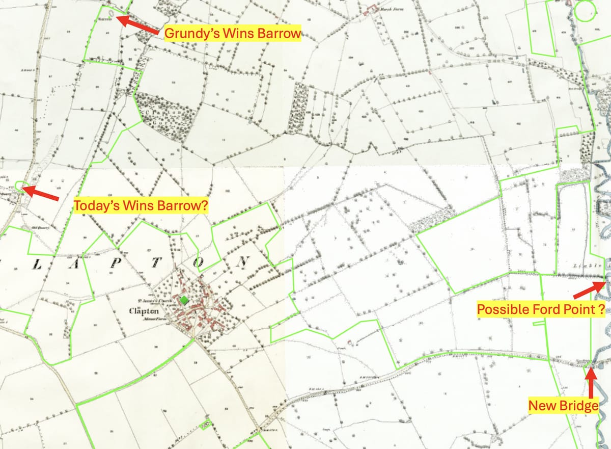
“on the south, the Ford of the willow trees to Wins Barrow”
He then assesses this “ford of the willow trees” to be about 400m north of New Bridge and Wins Barrow to be the point I have marked on the 1930s Ordnance survey as a possible Ford Point.

It’s here that I start to suck my teeth a bit on this eminent historian’s assessment. Grundy’s assessment of where the willow ford is, is weak. He thinks it is where the current parish boundary of Clapton meets the Windrush, and that there was once a ford there. I’m going to politely challenge this long dead historian by saying:
- Then parish of Clapton wasn’t created until the 19th C, its a subdivision of Bourton. Grundy didn’t notice that
- A ford implies a route, or a track and while there is a bridge there today, the course of the river has meandered over the centuries and the track crossing here is minor, probably recent, and heads to the North.
- But there is a clear ancient road/track that runs between Great Rissington and Northleach 400m south, and it crosses the Windrush at New Bridge
- The site marked on the 1930s map, and which Grundy thinks is Wins Barrow has been shown in recent investigations not to be a barrow at all.
- Grundy’s work in the 1930s is admired but nowadays criticised a little - he used 1920s OS maps which failed to consider some boundary changes, and he rarely visited “sites”. I suspect he didn’t know that Bourton parish was defined in the 19th C. My view is that the route between “his” ford, and “his” Wins Barrow or even the modern Wins barrow is entirely illogical and would have been illogical in Anglo-Saxon times. I challenge you to try to walk it. (Actually don’t there’s no right of way).
- A later Anglo Saxon charter in AD 949 of the area, defining a gift of land from King Eadred to “Wulfric” also mentions the “Ford of the willows”, but then mentions a ”way” in association with it:
“Aerest of Withig Forda andlang Weges to Pippenespenne”
Translated as
“First from the ford of the willowtrees along the Way to Pippens Cattle pen.”
I note that there is a cottage called “Pippins” in Clapton today, but when and how that cottage was named, I don’t know. Anyway, my conjecture is that the willow tree ford is at the site of what we now call New Bridge and that the “Way” must be the old road that goes from Great Rissington to Northleach. I think this road is ancient and much more likely to be used to define a boundary than anything else. Grundy does accept this as a possibility but dismisses it. I think he’s wrong to do that.
Now, since Grundy’s original assessment of the barrow has been proven to be incorrect, another bronze age barrow at the gate in to Bourton Hill Farm has “adopted” the title Wins Barrow. But this makes little sense to me. It sits, yes, on the modern parish boundary of Clapton, defined in the 19th C but there’s no clear boundary feature or object linking it to the Windrush to the east and to Broadwater Bottom to the west, where both charters take us. So I think this barrow, interesting as it is, has adopted the name Wins Barrow by accident.
But if we follow the current northern boundary of Sherborne parish (which I think was defined c AD 800 but the charter long lost in a fire in Winchcombe Abbey in the 12th C), this runs up the road from New Bridge, past two areas which I suspect are long barrows south of Clapton, across the Sherborne to Bourton road and on down west into Broadwater Bottom (the valley running North from Farmington). This is a boundary that is defined by ancient and modern features and clear if one “walks the ground”. I show it below on a modern map.
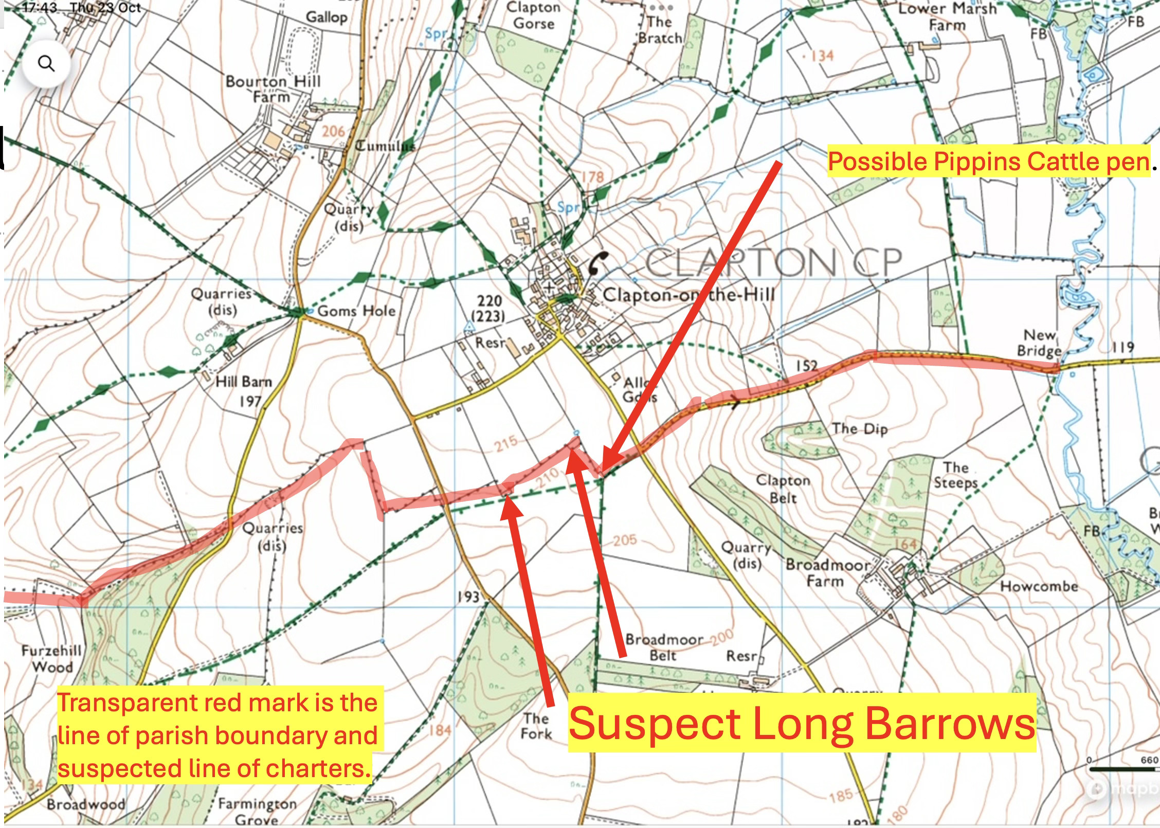
Now, the two suspect Long Barrows south of Clapton I reported on before after Brian Agg and I explored them. I did not get much support in my assessment that these linear features are Neolithic Long barrows from discussions with the Gloucester County archaeologist and that’s fair, but this is another new piece of the argument. In essence I’m saying this:
- It is accepted that Grundy’s Wins Barrow is a red herring. But I’m unconvinced by the naming of the barrow at the gate of Bourton Hill Farm as “Wins Barrow” to replace it.
- I think this analysis of the charters suggests one of the two sites previously identified on the Sherborne Parish boundary (an Anglo -Saxon defined boundary in its own right) is “Wins Barrow.” I suspect Pippins Cattle Pen was just to the east of these features and the “Wegen” in the latter charter is the road from Great Rissington to Northleach that crosses at Newbridge , once the site of the Ford of the willow trees, and runs up the steep hill, to Pippin’s Cattle pen then on Westwards
I’ll pass this politely to the Gloucester County Archaeologist and see if they are minded to rethink. I’m suggesting one of our two suspect Long Barrows is “Wins Barrow”. I can’t prove it, of course.
Let me know what you think. I know this was a complex argument (covering thousands of years, interpreting Anglo Saxon sentences and a lot of geographic analysis I have skimmed over) and it’s hard to get over in this medium. My apologies if I lost you.
All these things show how in the local area in Sherborne (and close by), we connect directly with the past – in this case to Anglo-Saxon times over a thousand years ago, to the Bronze Age 4000 years ago and the Neolithic 5500 years ago. These links across the ages are real and exciting. This history is there in front of our eyes – we just have to take the time out from the modern age to look carefully. It links us personally and that, my friends, is “heritage”.
