The Standing Stones
The surprising story of Sherborne's "megaliths" and why we should hit stones with sticks
This post is a bit of an experiment, a longer piece to see if Substack works for us as a vehicle for slightly deeper discussions. Let me know if it works for you or not.
As I flagged a few days ago, prompted by the question “What’s the oldest thing in Sherborne”, and my other investigations on the peculiar shape of the Northern Parish Boundary, I started to identify and record “standing stones” in the area. I was surprised by how many there are. I’ve also done a little contextual research and wanted to share that with you. This post is limited to the standing stones I have found for the Hundred/Parish Boundary. My next post in a few days will cover the others. So regard this as PART 1.
Some of these are clearly visible and some are “hidden”. Some are explainable, others have a mystery attached to them. Their ages vary, I think, from the Stone Age/Neolithic to barely a century old, and everything in between. The oldest of the stones answer the question“What’s the oldest thing in Sherborne”.
Philosophically, all these stones on the boundary or elsewhere, were raised by our predecessors in and around Sherborne to say something. It’s a bit of a detective story to work out what messages are being given to us from the past. In that sense I think it’s clearly important to cherish these stones and regard them as a key part of our heritage. At the end of this I’ll make some recommendations.
The boundaries of Sherborne are not just a geographical feature; they’re a man-made definition. In approximately 811 AD, King Cynewulf granted the estate of Sherborne to the Abbey of Winchcombe. This is a whopping 250 years before the Domesday Book and certainly older than any building we have today. King Cynewulf likely made this transfer through a “charter,” but unfortunately, the charter no longer exists and was probably destroyed in a fire at Winchcombe in 1151. However, I believe we can be reasonably certain that a fair part of the current Sherborne parish boundary aligns with this early medieval boundary definition. Many members of the Brook Group in Sherborne are aware that I’ve been researching the parish and “hundred” boundaries for several months now. It’s important to understand that “Hundreds” were established before parishes.
Anglo Saxon administrative areas, known as “Hundreds,” were defined between approximately 500 and 1100 AD. While some historians suggest that a “Hundred” could encompass one hundred farmsteads, this might be an oversimplification. Imagine a “Hundred” as between the size of a parish and a county, potentially containing half a dozen parishes or more. I’ll delve deeper into the administrative functions of a “Hundred” in a future post. For now, let’s focus on the boundary definitions. The western and southern parish boundaries of Sherborne are part of a “Hundred” boundary. This boundary starts just west of Clapton and runs south along Haycroft Farm, across the Brook, reaching the west of Oranges Farm before intersecting the A40. It then descends the side of the old deer course to Lodge Park. The “Hundred” boundary then continues eastward, almost reaching Windrush Camp. Considering the gift of Sherborne to Winchcombe Abbey in 811 AD, we can reasonably assume that this part of boundary dates back to at least that era. It’s possible the rest of the Parish boundary, to the East, has a similar age or it could be later.
Interestingly, north of the Brook, on the western edge of the Hundred, running up to Clapton, the boundary is, or was once, marked by a double hedge or double wall. Someone wanted to emphasize the significance of this 1250-year-old boundary. It’s beneficial to understand how these boundaries were designed and recorded. We have other Anglo Saxon charters in the local area that still exist as documents, allowing us to compare them. One notable charter from the late 700s runs west from Swell, north of the Slaughters. The most important aspect to grasp is that these charters were not in Anglo Saxon times defined on a map. Maps were not at all common then; in fact, to all practical purposes, maps likely did not exist as a concept for the average Anglo Saxon. Imagine yourself as an Anglo-Saxon civil servant, a clerk working for the local lords. The land wasn’t “developed” as we know it today. While there might have been some fields, the agricultural system was probably quite loose. However, what truly mattered to both owners on either side of the boundary was the clear definition of that boundary. But how did they achieve this? How did they define an area and proclaim, “This side belongs to you, while the other belongs to your neighbor?” in unarguable terms? Well, they employed a “list” of sorts. They utilized recognizable and unarguable pre-existing features in the landscape as descriptors for points on the boundaries.
For instance, a charter might specify something like this:
- Starting from the bridge over the river, follow the old street until you reach the thorn bush. Then, turn west and ascend the hillside hedge until you reach the round pagan burial mound. Continue along the hedge until you reach the standing stone. Finally, turn south and follow the path until you reach the long pagan burial mound. Then, descend the side hill until you reach where the stream meets the river.
So, a charter will have a list of points that help define a recognizable line in the countryside, serving as the boundary. Now, here’s the crucial aspect, The Anglo-Saxon clerk didn’t create these points; he merely utilised them, exploiting their presence as a valuable boundary marker. Consequently, historical points mentioned in the charter are generally older than the charter itself. They have existed for a long time and have proven to be enduring, sometimes spanning thousands of years. If they mark a boundary, they are more likely to be left undisturbed over the centuries, unlike other ancient features elsewhere off the boundary such as stones and burial mounds, which may disappear due to erosion, theft for their stone, or ploughing out.
But there’s more. It’s possible that some Anglo-Saxon boundaries were remnants of earlier, possibly Roman British estates. Certainly, the economic collapse following the Roman evacuation around 410 AD, coupled with subsequent economic collapse and the disruption caused by the influx of Anglo-Saxon immigrants beginning around 449, likely wiped out many estates from the landscape. (Bloody Anglo-Saxon immigrants, coming over here, taking our jobs…) However, I expect some estates persisted in some form or another in certain places, at least because the Romans were adept at marking boundaries. The Romans also employed an intriguing strategy with their boundaries. They erected boundary stones alongside paths or routes that traversed from one territory to another. In fact, they even celebrated a religious festival known as Terminalia, which underscores the profound significance of boundaries. This festival is believed to have been held annually on February 23rd, which is why I’m sharing this information now. Here’s a link to the Wikipedia page for Terminalia: https://en.wikipedia.org/wiki/Terminus_(god)#:~:text=In%20Roman%20religion%2C%20Terminus%20was,each%20year%20on%20February%2023. Interestingly, the Romans even made it a capital offense to destroy a boundary stone. Now, let’s consider the implications of this for us in Sherborne. For the sake of argument, suppose there’s a prominent (or perhaps not so obvious) stone located on or near the parish boundaries of Sherborne . What could this stone possibly be? There are several possibilities we should explore:
- It’s simply a coincidence. There are numerous quarries in the area, and it’s plausible that some stones ended up on the boundary.
- The stone serves as a straightforward and effective gate post.
- The stone was erected by a farmer in the not-too-distant past to mark his boundary.
- The stone was erected during the Middle Ages to mark a boundary.
- The stone was erected by the Romans to mark a boundary. There were plenty of Roman estates in these parts.
- The stone was part of an ancient burial mound that often featured large stones at its entrances. Perhaps the mound itself has gone leaving the stones. This has happened at numerous places in the region. Burial mounds were frequently positioned on ridgeways or false ridges that made them appear on the horizon. There are indeed many locations on Sherborne’s boundaries that lie on such features, and I think that’s interesting.
Of course, it’s possible that a stone may have multiple purposes. For instance, it’s conceivable that an existing Roman terminal stone was later repurposed as a gate post.
So, are there any such large stone objects on Sherborne’s boundaries that could be potential candidates for the oldest thing in the village? Or hints that large stones once existed on or adjacent to the boundary? Yes, there are!
Here are a few intriguing possibilities. It’s up to you to decide which category they fall into from the list above.
Here’s a map of the first three:
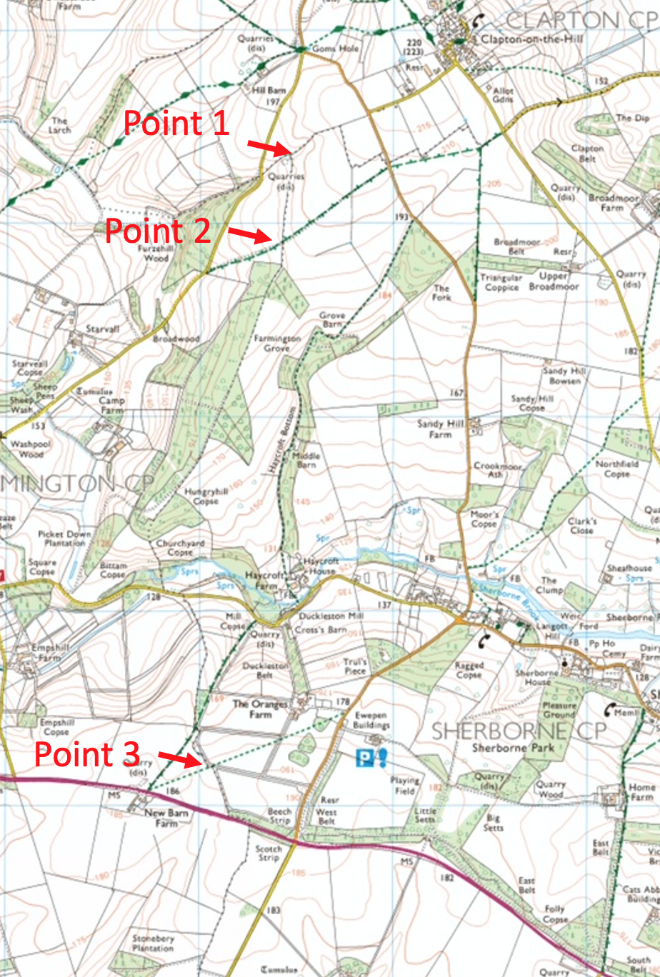
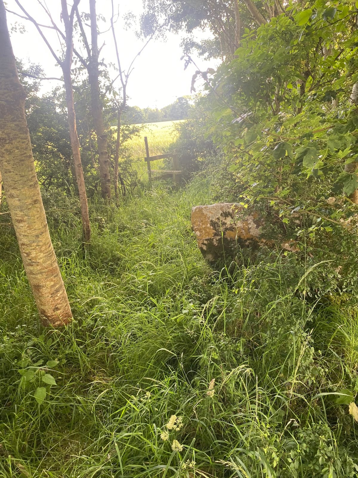
Point No 1: On a Victorian Ordnance survey map, right at the North West corner where the Sherborne Parish boundary meets the hundred boundary that runs mainly north to south, there’s a letter “P” for post.
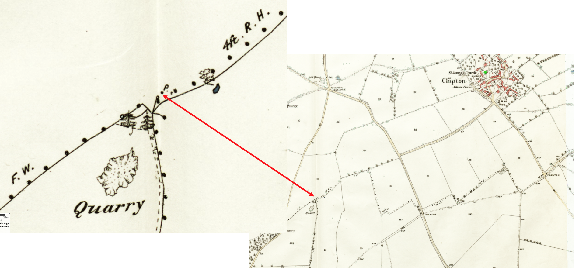
I suspect that this was actually a stone post at this crucial point, a corner, but it has fallen or been removed. More investigation is needed. It may still exist under hedge or built into a wall. I also think it might be significant that this point offers fabulous distant view of the area looking NW. There’s another fabulous view, for what it’s worth at the SE corner of the Parish, where the parish boundary turns North at Budgehill towards Windrush Camp.
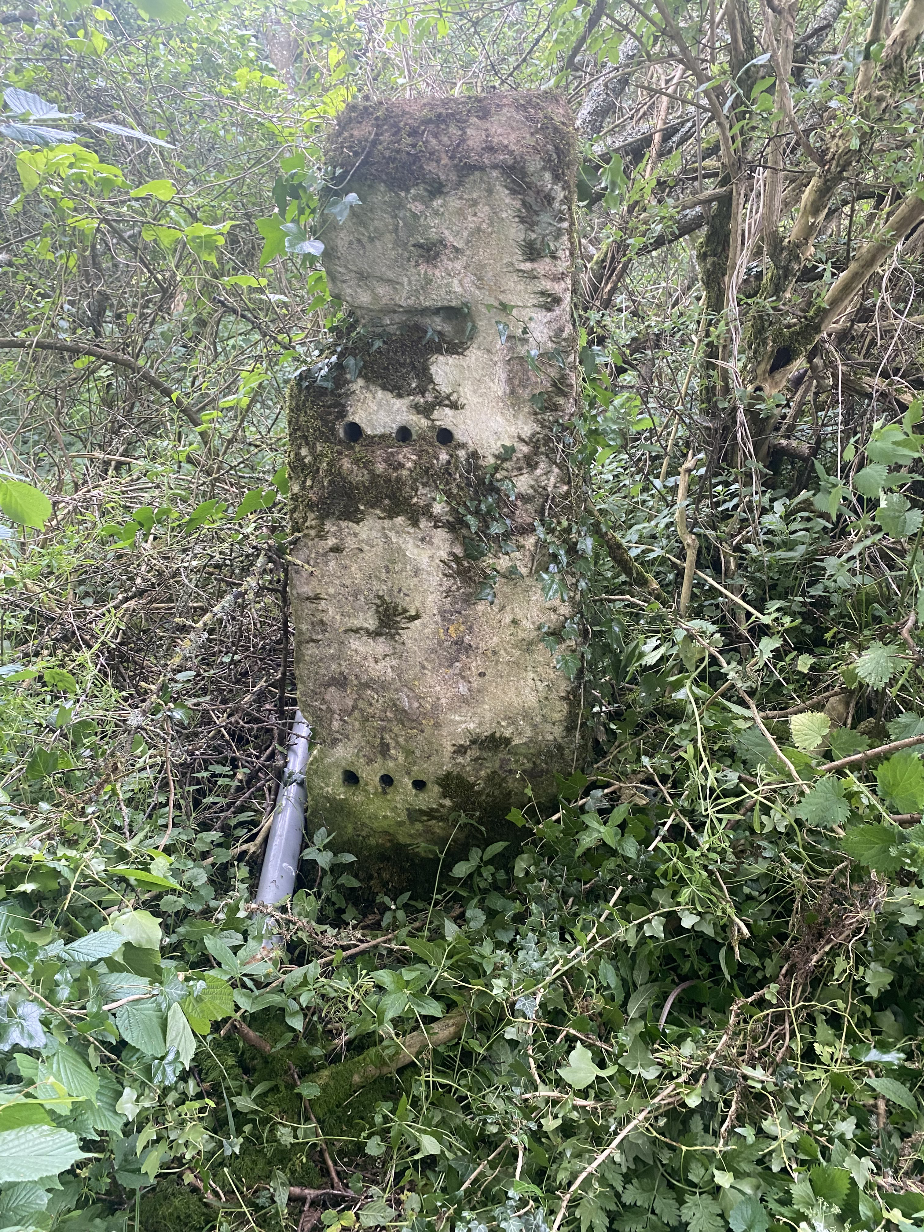
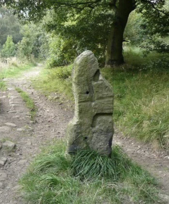
Point No 2: This is a large stone that I’ve discussed before. It’s located where the track from Great Rissington to Northleach crosses the hundred boundary. It has been carved in a peculiar way, and there are numerous holes drilled into it, some of which could have been used to hang a gate post. Other holes drilled in the pillar are harder to explain. The boundary here was significant as it formed a double boundary wall. Could this stone be Roman?
For what it’s worth here’s an image of a known Roman boundary stone elsewhere in the country for comparison. I see some similarities:
Point No 3: There are several large stones where the path between the gate of Oranges and New Barn Inn crosses a hedge line on a zig zag of the hundred boundary. Are they remnants of something more significant? One appears to be a standing stone, while another could be similar but fallen. There are others in the immediate area. More research is needed to understand these. This point does stand on a ridge line when viewed from the North. These stones are of a similar size to the stones at the entrance to the Long Barrow in Lodge Park. This boundary stretch here, a zig-zag about 30m long , is also aligned to the Equinox sunrise. I have a strong hunch it is the remains of a neolithic Long Barrow. That would make it 5500 years old and the oldest structure in Sherborne. More investigation needed! There is some lovely spooky local folklore about this place that I’ll whisper in your ear if you come to the walk we have scheduled next month.
Now here’s a map of the last two:
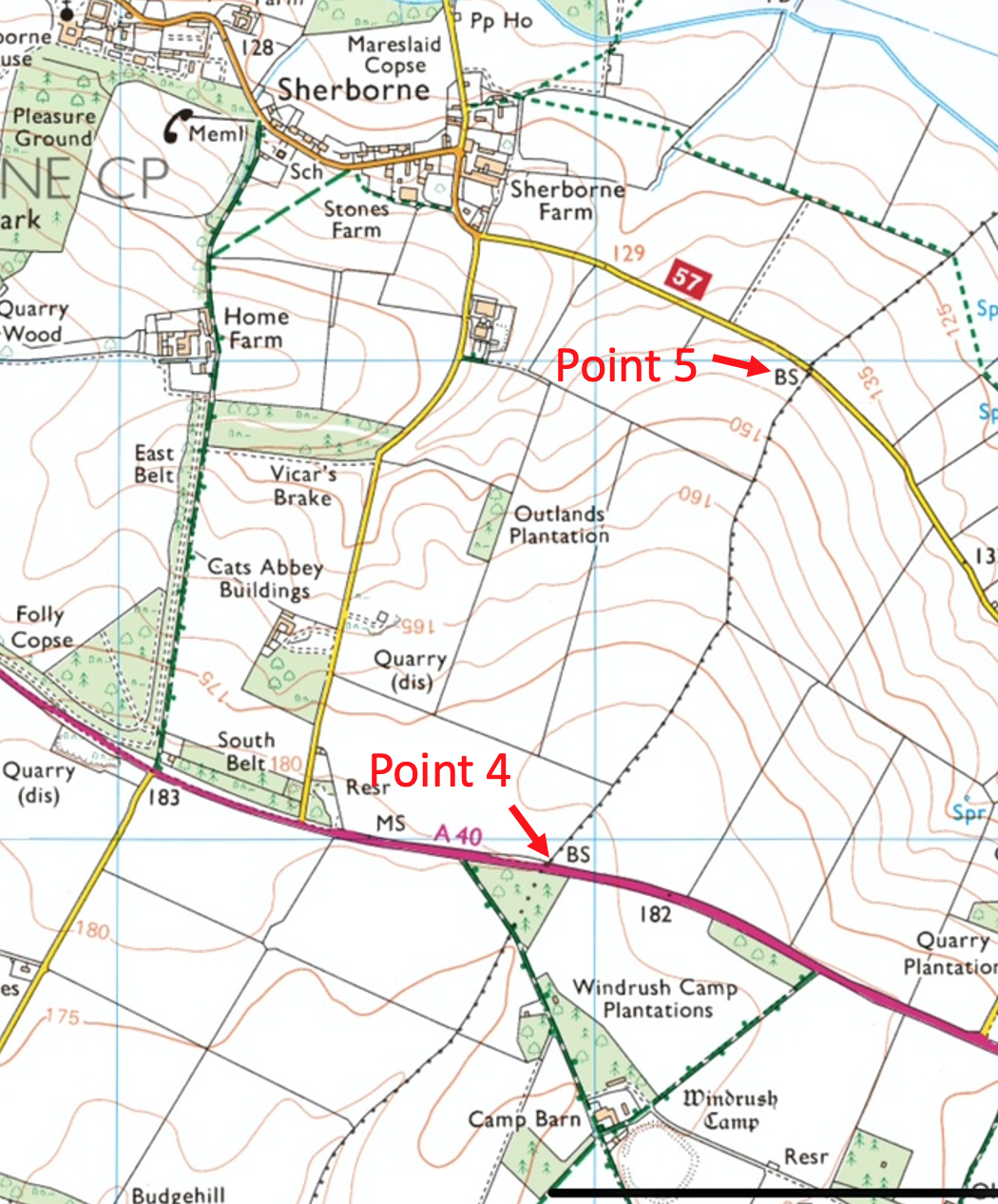
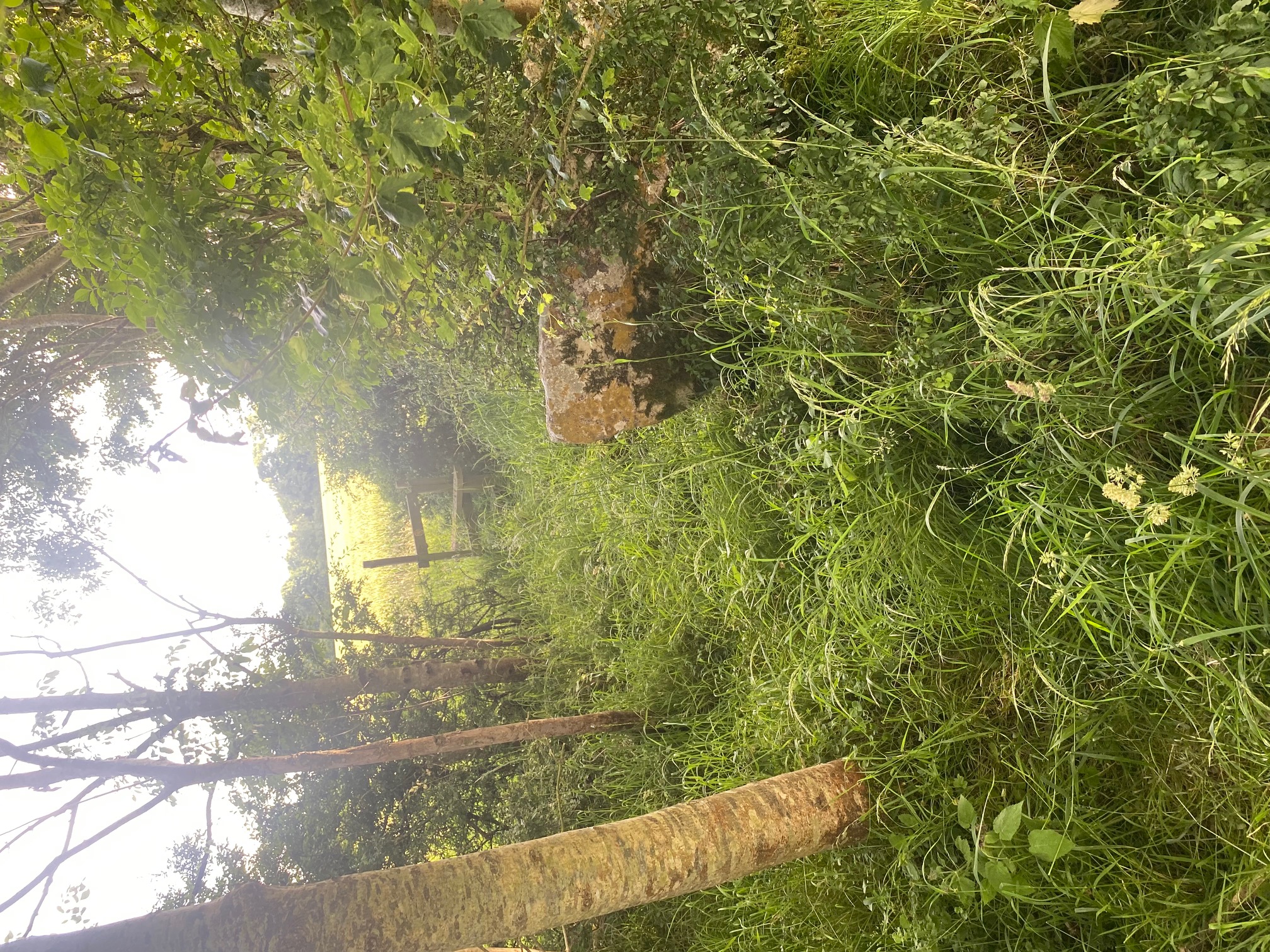
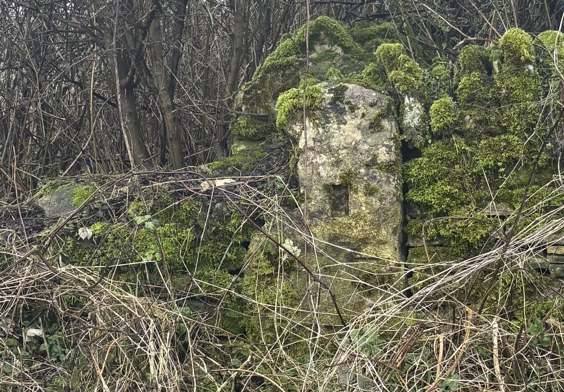
Point No 4. The modern Ordnance Survey map notes “BS” where the A40 cuts the parish boundary. BS = Boundary stone. I have not investigated this spot yet. I’ll post a pic once I have braved the A40 traffic and some dense undergrowth.
Point No 5. Another BS is noted on the road between Sherborne and Windrush. surprisingly this boundary stone is clearly visible as you drive along the road, and has some very odd shapes carved into it. I see some similarities with Number 2. This is the easiest boundary stone to get to and see - sat in the seat of your car. It’s on the right as you drive towards Windrush. What do you think the rectangular socket carving is for?
So those are the “standing stones” that sit on the Hundred/Parish boundary. But there are quite a few more, perhaps a dozen of them. Some of these are even more peculiar and some raise more questions than provide answers, I’ll cover these in my next email.
To finish, I’d like to make a comment about the cultural importance of these boundary stones. Prior to maps existing how did these boundaries get passed from generation to generation? How were these boundaries known across the community? The answer here is that rather lovely word “perambulation”. Traditionally there was an almost ritual event, at Rogationtide, just before Ascension Day. The village priest would lead the whole community on a “perambulation” around the parish boundary. At each key point, prayers might be said, oaths taken and in many parts of the country small boys would “beat” the boundary markers with sticks. One of the little boys in the early 1800s would be the elderly gentleman who was nominated to be the Sherborne “meresman” for the 1880 boundary survey that I wrote about a few weeks ago. He was illiterate but by golly he knew the boundaries - and this is why and how. This ritual has the result of impregnating in everyone’s brain where the parish boundary is, and it is publicly known. The spooky local folklore about these places would also no doubt be repeated and reinforce everything in peoples minds. I think this has links, with not too much imagination, to the Roman Terminalia festival. The key thing is it is a public ceremony. No-one can say “Oh I didn’t know”. I suspect that it is only since the new-fangled invention of Ordnance Survey maps in the 19th Century and the boundary surveys of the 1880s that made the perambulation redundant. As far as Sherborne is concerned it’s a good nine mile walk.
This then indicates that the boundary and the markers on it are very much part of the community heritage here. Once they were more apparent, and I’m certain there were more than I list here. I think we should seek out other boundary stones. I think we should pull away any undergrowth (with the landowners permission, of course). I’m not suggesting we scrub off any lichen but we should certainly inspect them for carvings and marks and any other clues for the uses they have been put to. Every time I drive to Windrush I now pass that boundary stone and it makes me think - How old is it, who put it there, what stories can it tell? This is heritage to be celebrated, it is heritage owned by us as a community, morally. It tells us about our past and makes a marker for the future. It defines our relationships with our neighbouring parishes. It emphasises the importance of land and landscape. That’s reinforced by the fabulous views from some of them. See where they sit in the landscape. Perhaps we can “reinforce” our borders in the nicest possible way with the planting of some of our ancestor oak trees. If, like me, you are a small boy at heart, hit it gently with a stick! Whisper the folklore tales and get a shiver down your spine. (Such things are not for this medium). It’s all about the importance of heritage. If you know the borders of Sherborne as a community, you know where you are from. You know your home territory, you know yourself, and it grounds you.
Let me know what you think. You can subscribe to these posts below, it’s entirely free and will remain so. You can unsubscribe anytime. I’d encourage you to comment. you can get a Substack app if you wish, but no need to if you want to continue to get these posts as emails.

Get more from Roger Davies in the Substack appAvailable for iOS and AndroidGet the app
I’m exploring providing these posts as audio podcasts with the help of a bit of AI. Let me know if that would be of interest.
