Uncovering Ancient Secrets: Possible Neolithic Barrows on the Sherborne-Clapton Boundary
Back to the zig zags for the latest discoveries from last weekend.
For several months, and before we moved these newsletters to Substack, I've been investigating the peculiar zig-zag northern parish boundary between Sherborne and Clapton. What started as curiosity about these unusual boundary patterns has evolved into an exciting archaeological discovery that might connect us directly to the first settlers of our area from 5,000 years ago.
The History of Our Parish Boundary
The parish boundary of Sherborne was likely established in the late 8th or early 9th century by King Coenwulf of Mercia when he gave the estate of Sherborne to the Abbey of Winchcombe. This transfer would have been defined in a charter. Although that charter was destroyed by fire in the 12th century, I strongly suspect today's parish boundary follows that Anglo-Saxon defined estate boundary. Originally, the boundary was with the parish of Bourton on the Water, but subsequently part of that area became the parish of Clapton.
Anglo-Saxon charters didn't use maps as we do today. Instead, they defined boundaries using a written list of existing landmarks – permanent, unarguable geographic features that could be walked from point to point. In those days, pre-existing ancient burial mounds, including long barrows, were more obvious (having not yet been destroyed by centuries of ploughing) and were often used as defining features. This suggests that odd points on our boundary might indicate prehistoric features.
The Hunt for Lost Barrows
Long barrows from the Neolithic age and round barrows from the Bronze Age are fairly common in our local area, although many have been flattened by centuries of plowing, erosion, and secondary quarrying for stone. I suspect the majority of barrows and burial mounds have suffered this fate and are now forgotten. that means there are some out there to be discovered in our local landscape.
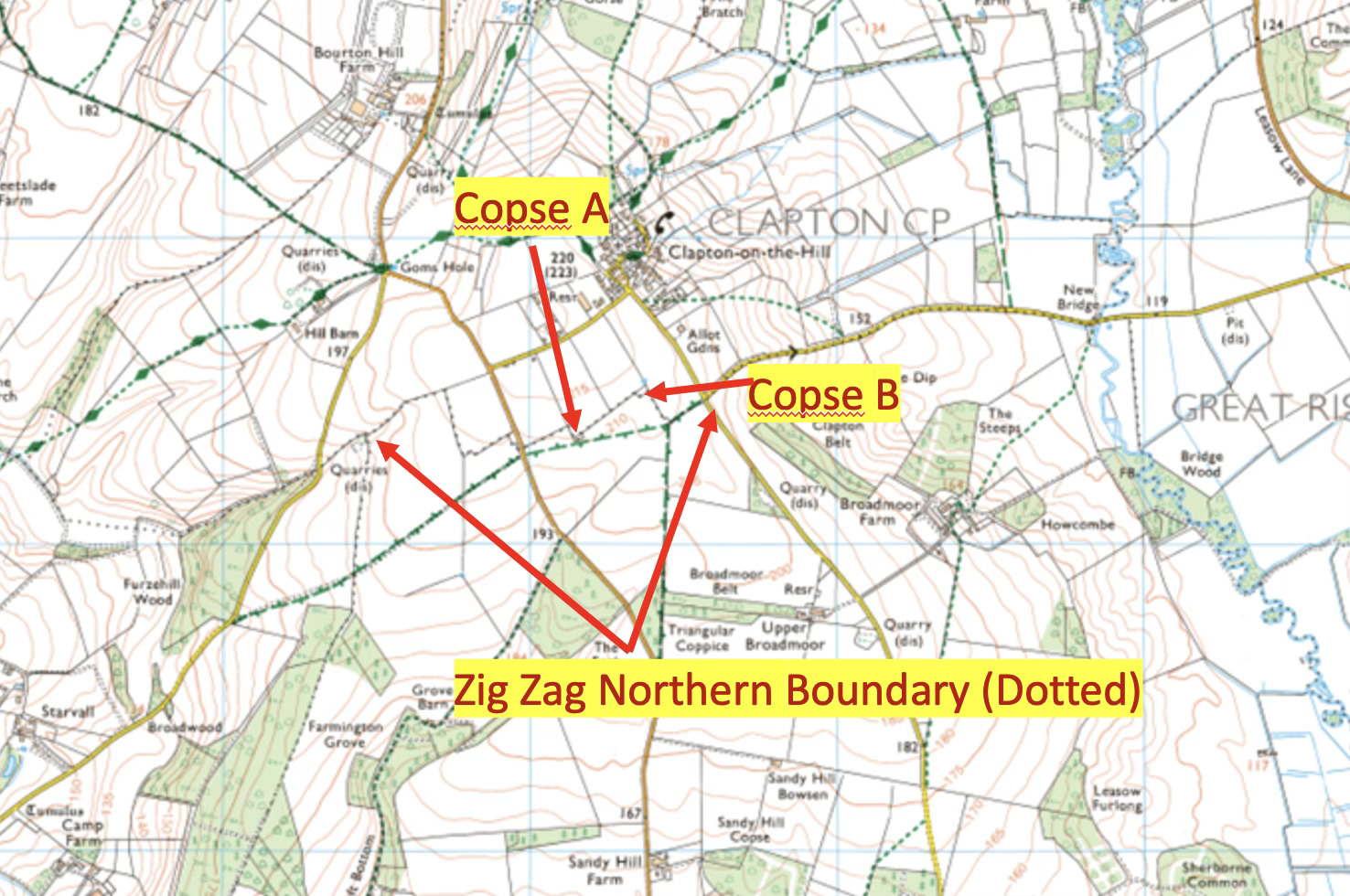
There are points on this northern boundary, which zig-zags across the countryside, that might be or might once have been burial mounds. Some of the larger "zig-zags" can be attributed to medieval field patterns (with typical dimensions of 220 yards), but there are odd little rectangular enclosures that aren't easily explained by that.
By studying the geographic characteristics of known long barrows in our area, I've identified several common features:
- They're typically positioned on ridge lines or false ridge lines above valleys, appearing on the horizon when viewed from the valley
- They're usually oriented roughly east-west, with the broader opening to the east
- They tend to be trapezoidal in shape
- They're generally 20m or more in length
- They're often within sight of other barrows, sometimes with alignments at solstice or equinox
- They're frequently near quarries
- They're sometimes near springs or water
- They're often near paths, roads, or tracks
- They're typically on or very close to parish or hundred boundaries
- They're frequently invaded by badgers who may find the characteristics of a mound with voids ideal for their purposes
The Rectangular Woodland Enclosures
The small rectangular wooded compartments on our northern parish boundary match many of these characteristics:
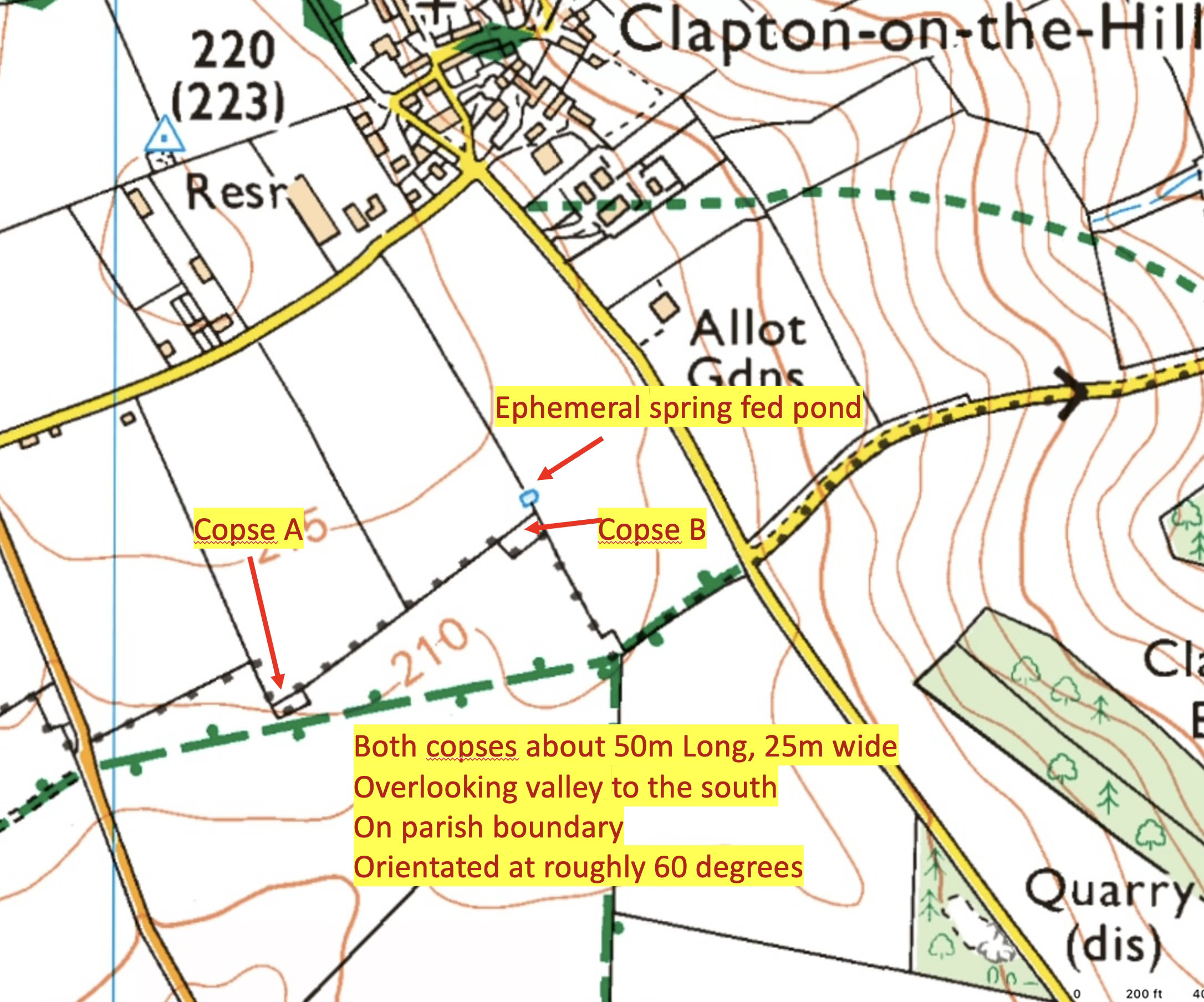
- They're the right size, about 50m in length
- They sit on a false ridge when viewed from the south
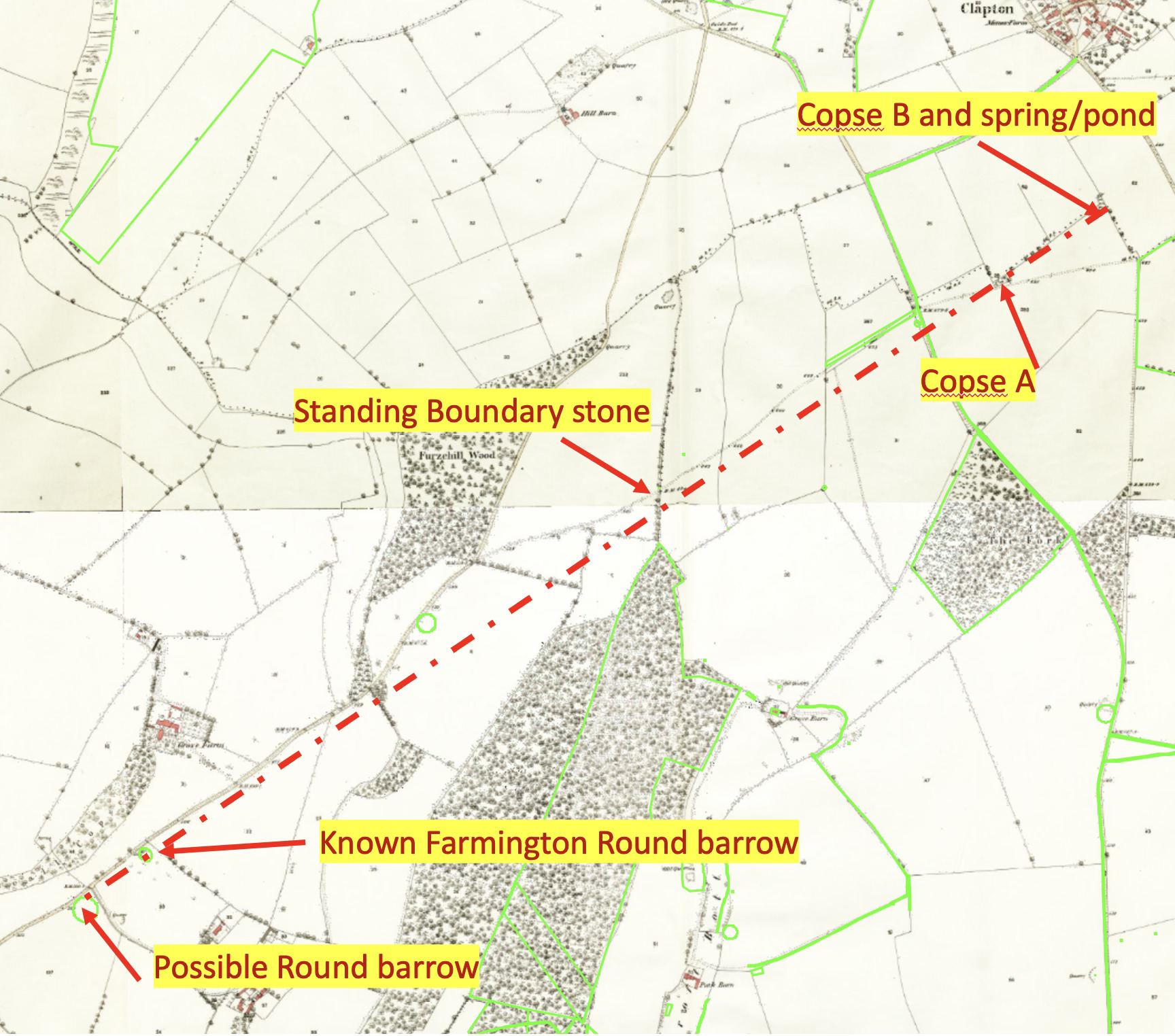
- They form a line along that apparent ridge and also align with two known round barrows in Farmington a mile and a half away
- They're positioned on an ancient Anglo-Saxon charter-defined boundary
- They sit alongside an ancient path, once a track, that runs from Great Rissington to Northleach
- They have the right orientation, generally east-west
- One has a pond/spring associated with it
Here’s the alignment with two round barrows in Farmington to the SW, and also to the unusual Boundary stone on the hundred boundary previously discussed:
My research has been thorough, examining old estate plans, historical maps up to modern OS maps, the 1880 Boundary Survey, aerial photography, and LIDAR images (though none of these latter gave great clarity).
The Big Reveal!
This weekend, another member of the Support Group with significant local knowledge accompanied me to finally investigate these two small rectangular copses on the boundary. What we found startled me. I was expecting just rough woodland, but there is much more going on—and it's very exciting. We were thrilled to discover features indicating sites of definite archaeological interest and possibly Neolithic long barrows.
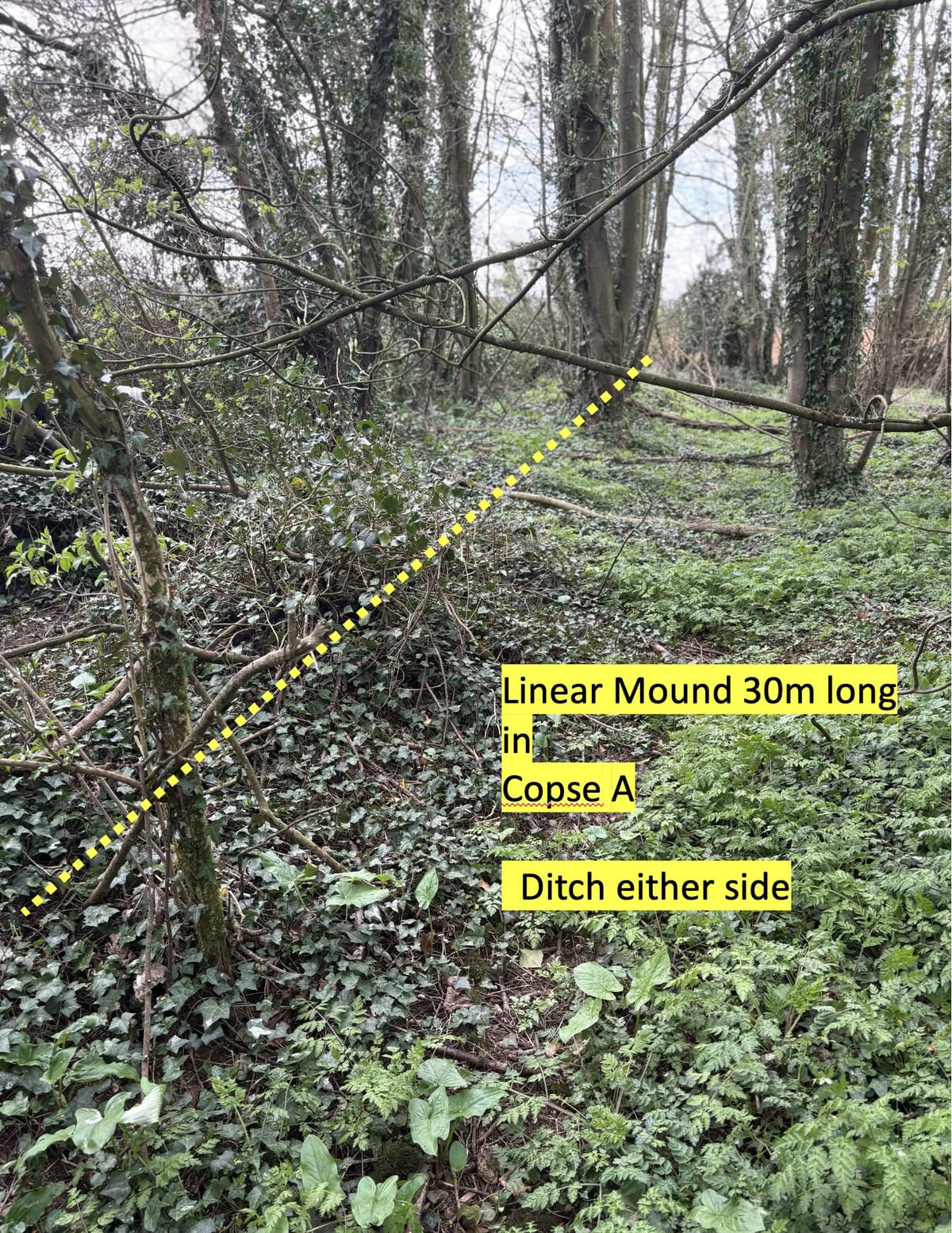
In Copse A, we found an apparent linear mound 60cm high, with ditches on all sides. There was a hint that the mound was wider at the eastern end. It's about 30m long.

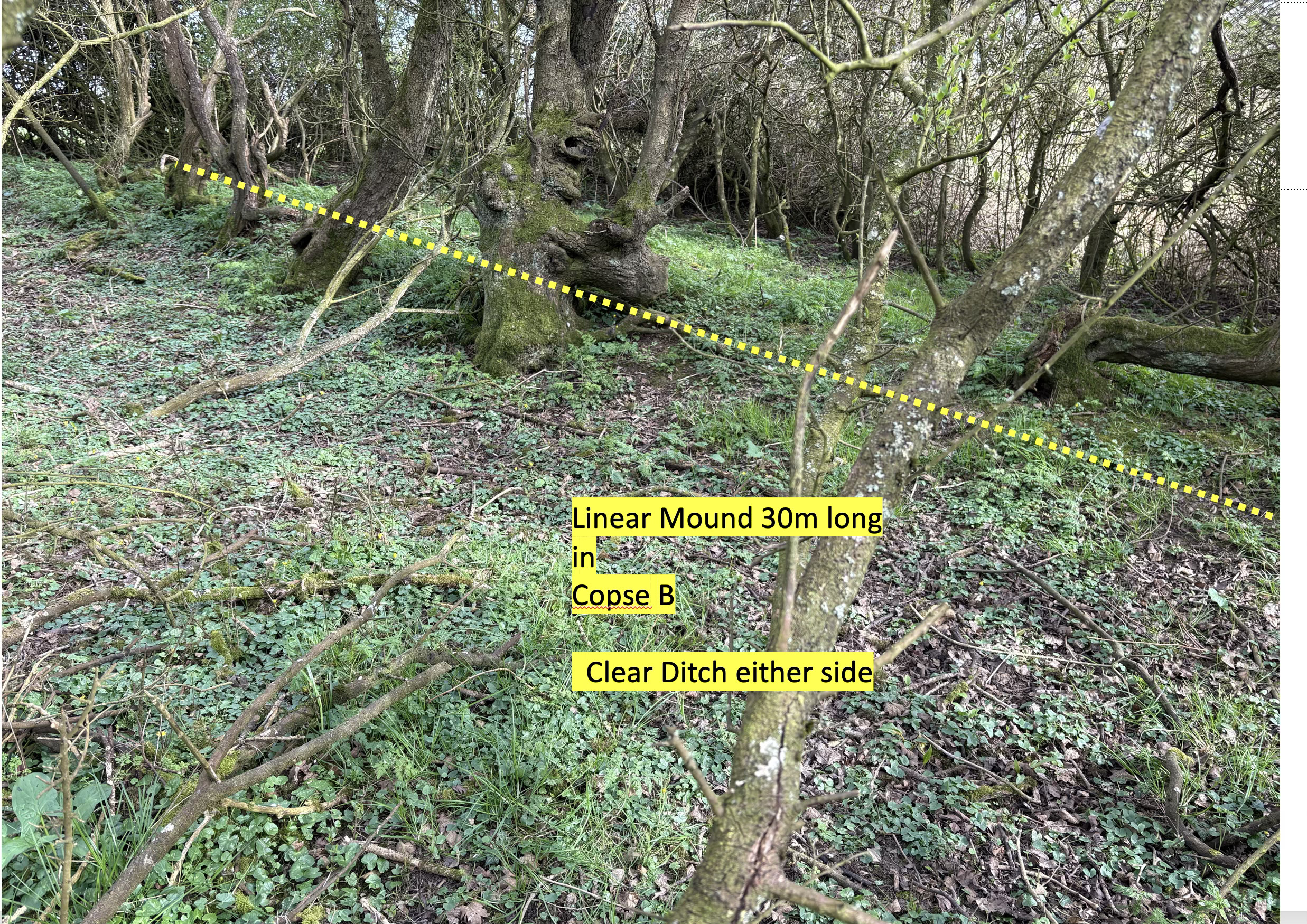
In Copse B, we discovered a more complex set of features, including a defined rectangular shape with clear mounds, apparently very old, forming a rectangle with internal ditches and another longitudinal mound within, toward the eastern corner, itself aligned roughly northeast. A pond is marked on maps 20m NE, but wa snot accessible today.
While I can't say with absolute certainty, as an amateur, that both are long barrows, they are certainly man-made features, and old. It's entirely possible that both are long barrows, dating from the Neolithic period (3000BC or more) and that Copse B is a rectilinear mortuary enclosure containing a barrow. They would have been more clear to the Anglo-Saxon cleric/clerk working for King Coenwulf in about 800 AD who will have used them as features on the Sherborne estate boundary. If they are what I suspect, these 5000 year old structures are from the very first settlers of this area. Older than the pyramids and literally on our back door. How about that? That gives me a buzz, and I hope it does you too.
Next Steps
My next step is to report these findings to the county archaeologist and see what they say. I’ll let you know. I'll also investigate some other points on this boundary in due course.
You may dismiss my investigations as a lunatic obsession—I'm thick-skinned and won't be offended. But I assure you, I've done my homework, and these features match with what we know about Neolithic sites in our region. The possibility that we might have uncovered a direct connection to people who lived here 5,000 years ago is both humbling and exciting.
To remind you, in the last year we have discovered a likely Long Barrow in Sally Coppice in Lodge Park, a very possible Long Barrow on the deer course beside the parish/hundred boundary near the Woeful Lake turn off (link), a possible barrow on the parish/hundred boundary just off the Sherborne Farmington road, and the “Nosebury Barrow” in Windrush. That’s quite a collection.
Our landscape holds many secrets, and sometimes the boundaries that define our modern communities are also the keys to unlocking our most ancient past.
Please let me know what you think, especially if you think I’m wrong. What have I missed, what have I misinterpreted? All comments welcome.
