Was there a Sherborne Saltway?
Evidence of an Iron Age Trade Route Through Sherborne
I'm embarking on another historical investigation, possibly dating back to Iron Age Sherborne. This research began thanks to a marvelous historic estate map loaned to me by the Sherborne Archives. The archives deserve our support—they house a treasure trove of material and are passionate about the social history of Sherborne. I'd urge you to support them.
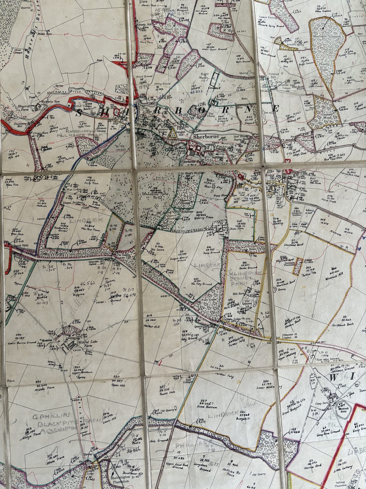
The map dates from perhaps the 1930s, based on a 1920s Ordnance Survey map, but is beautifully annotated with field areas and every field name written in immaculate tiny handwriting.
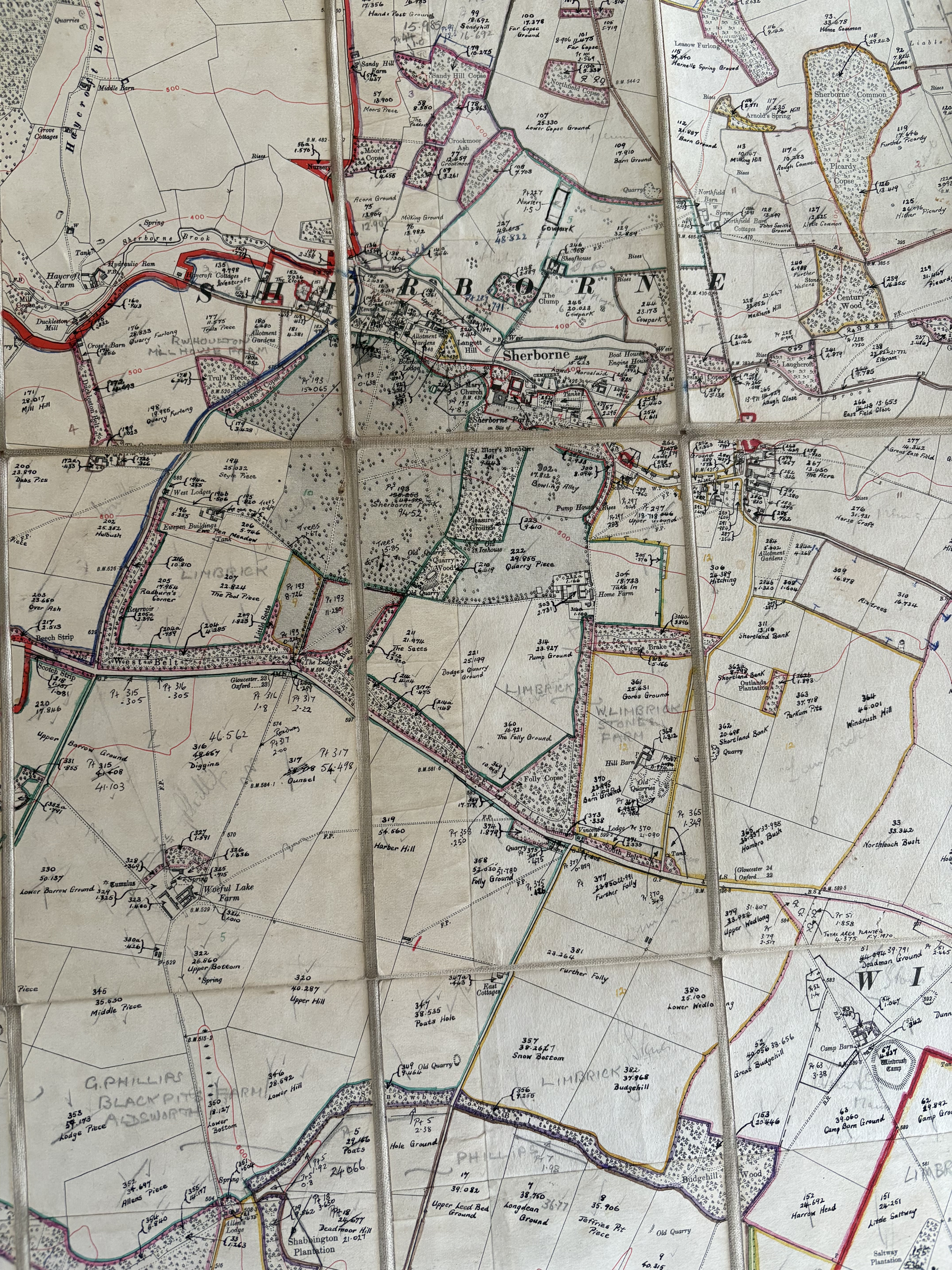
What's particularly interesting is that occasionally the field names differ from what we know today or from further back in history. This shouldn't surprise us, as these things evolve and change, but it's fascinating nonetheless.
The Discovery
This map contains annotations of field names to the southeast of Windrush Camp—the Iron Age camp just over the A40.
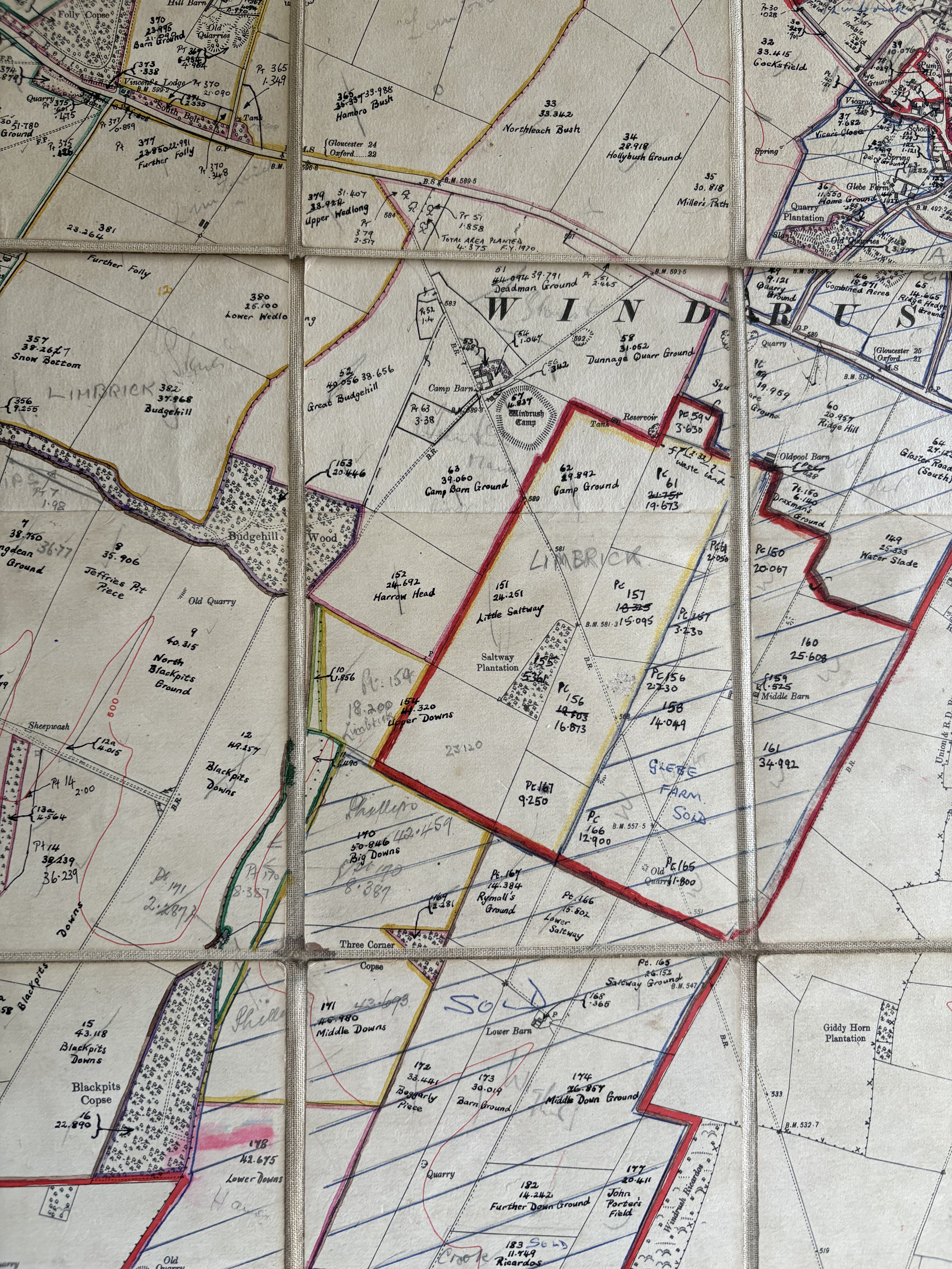
I noticed some field names that made me take notice and if you look carefully at the above image you’ll see them too:
- Little Saltway
- Lower Saltway
- Saltway Ground
All these fields lie along a roughly diagonal track that runs past the "entrance" to the Iron Age fort.
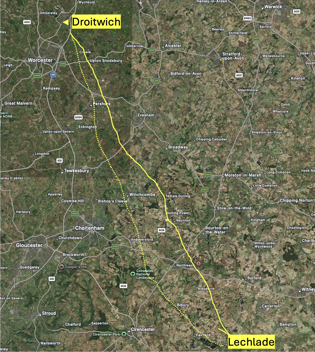
During my local cycling explorations around the landscape, I've encountered other "saltways." One runs roughly north-south through Hazleton to our west, continuing through Bibury and on to Coln St Aldwyns, then to Lechlade. This route originates from Droitwich in Worcestershire.
The Historical Context
Droitwich has a very interesting salty spring and has been producing salt industrially for thousands of years. Salt has been an important commodity throughout history. The salty spring water was fed into containers and the water evaporated off. The volumes of salt produced, even in ancient times, were remarkable. It was certainly an industrialized resource in Roman times and earlier, extending back into the Iron Age. Some sources suggest production even during the Bronze Age.
Droitwich was a significant center of Iron Age and Roman industry, continuing through the centuries until only about 100 years ago. It's estimated that at the time of the Domesday Book, a thousand years ago, it was producing 1,000 tons of salt annually.
The Distribution Network
Throughout this long history, a significant distribution network was needed to transport these volumes of salt. There was a network of tracks radiating out from Droitwich in all directions, likely with pack animals moving tons of the commodity. A key track is thought to be the one mentioned above to our west, which carried salt to Lechlade—an inland port where it could be transferred to rafts, boats, or barges for further shipping.
Would it make sense to have just one route throughout that entire period of history from the Iron Age onwards? Or would there have been multiple routes? Multiple routes would keep traders on route competitive - (“Oh you don’t want to go through Bibury, they charge too much for beer and grazing - head for the Sherborne route…”) The track to the west of us climbs the Cotswold escarpment at Winchcombe, but what if there was another route up the escarpment, past Stanway, following the route to Ford, Guiting Power, Cold Aston, and on towards Sherborne?
Here, roughly (very roughly!) is the course of the two routes between Droitwich and Lechlade, the solid line being the one under investigation. My guess is professional, fit and healthy pack horses and drivers could do a round trip in 3-5 days.
Evidence and Implications
Returning to that trackway near Windrush Camp, where the fields reference "saltway":
- Strategic Position: The track runs past the gate of the Iron Age camp, suggesting they might be contemporaneous. Perhaps the camp's position on the track was deliberately chosen to provide security for the route. This can't be mere coincidence—I think it's potentially significant. One can extrapolate the saltway southward past Eastleach and on to Lechlade without difficulty.
- Route Through Sherborne: Where does this track head through Sherborne? It's difficult to determine due to land development during the medieval period and later. The key would be identifying where it crossed Sherborne Brook. I'm investigating this, checking clues from crop marks, LiDAR, and topographical considerations. Some clues are already appearing but I’m reluctant to commit until I have checked a few more things and sought your input. What do you think? It’s fun to look at a map, look at directions and topography and imagine where our predecessors might have trod these steps 2500 years ago.
Conclusions
What we can know for certain, I believe, is that an Iron Age route of some importance between Droitwich and Lechlade ran through Sherborne. Remember, the A40 wasn't created until the 18th century, and the Iron Age camp wasn't positioned there to catch the S2 bus to Cheltenham. Imagine a secure way-station where pack animals could graze, where “security patrols” could base themselves. Perhaps an overnight stop for busy traders.
It seems certain that if you stood in Sherborne 2,500 years ago, a steady column of pack animals laden with salt would have trudged southwards across the brook and found their way on to Windrush Camp and then on to Lechalde—a trade route of regional importance, and a duplicate of the saltway that runs through Bibury. I assume empty pack animals would also trudge the other way to reload - perhaps they carried trade goods obtained in Lechlade.
As I uncover more possibilities regarding this ancient trackway's course through Sherborne, I'll keep you informed. Our history and heritage surrounds us here, we are knee deep in it, and I find it thrilling.
