Why Build Lakes Here?
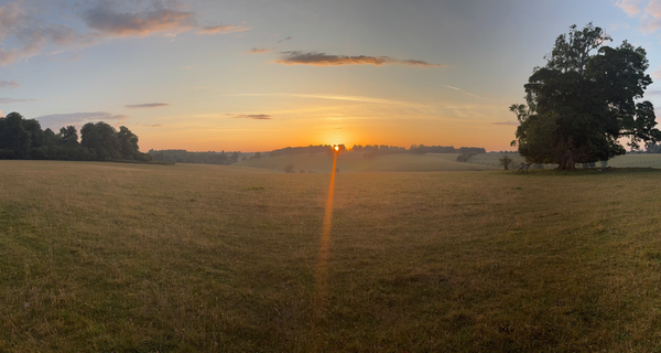
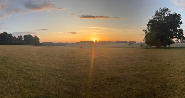
From the Sherborne village road, two prominent lakes are clearly visible in the valley below — albeit somewhat choked with vegetation. They are easy enough to see. They have, it seems, been easy to misread.
This piece sets out what we believe these two dams were actually built for, why that matters for how they should be managed, and why a suggestion that has been made about their purpose does not hold up to scrutiny.
Two Dams, Not One
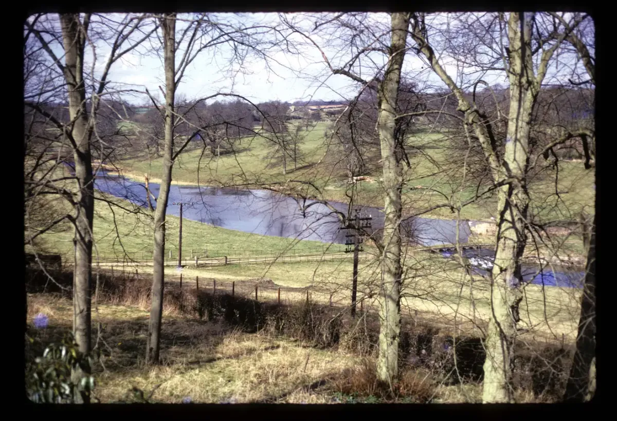
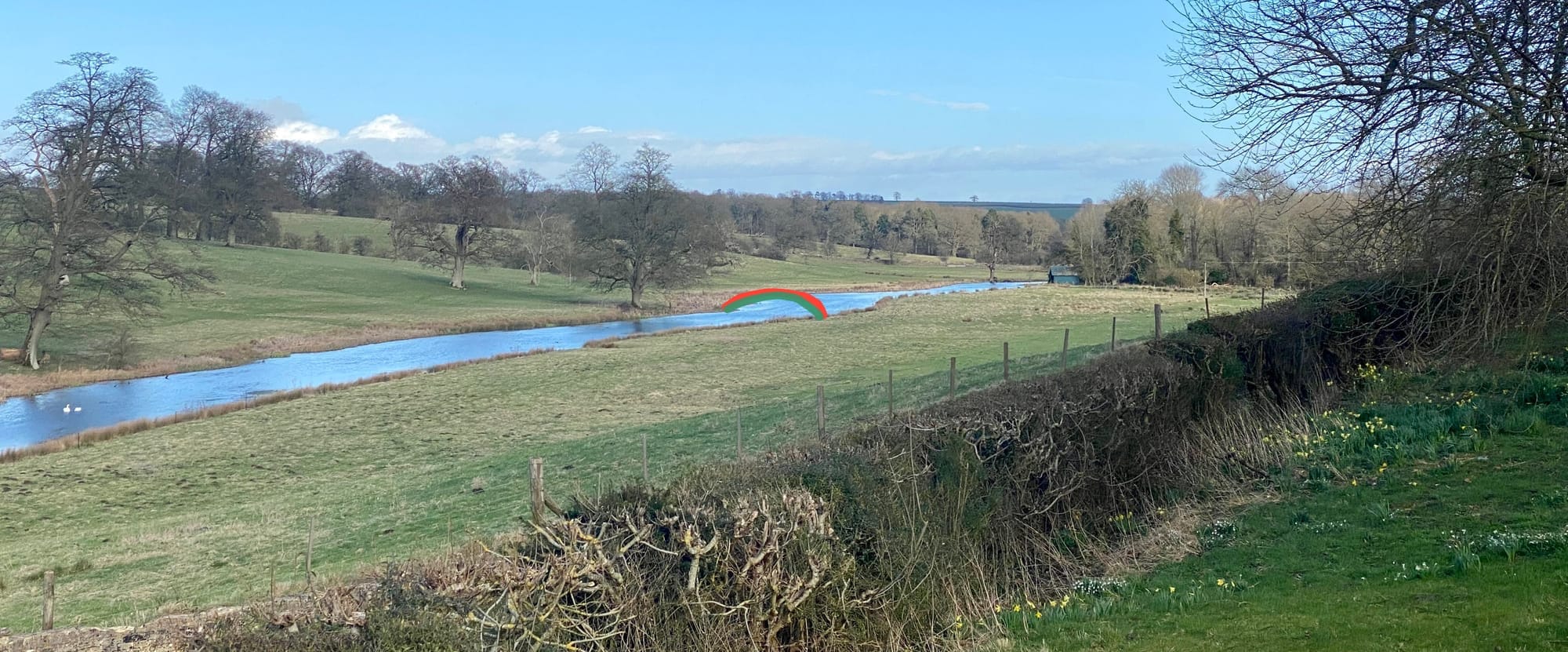
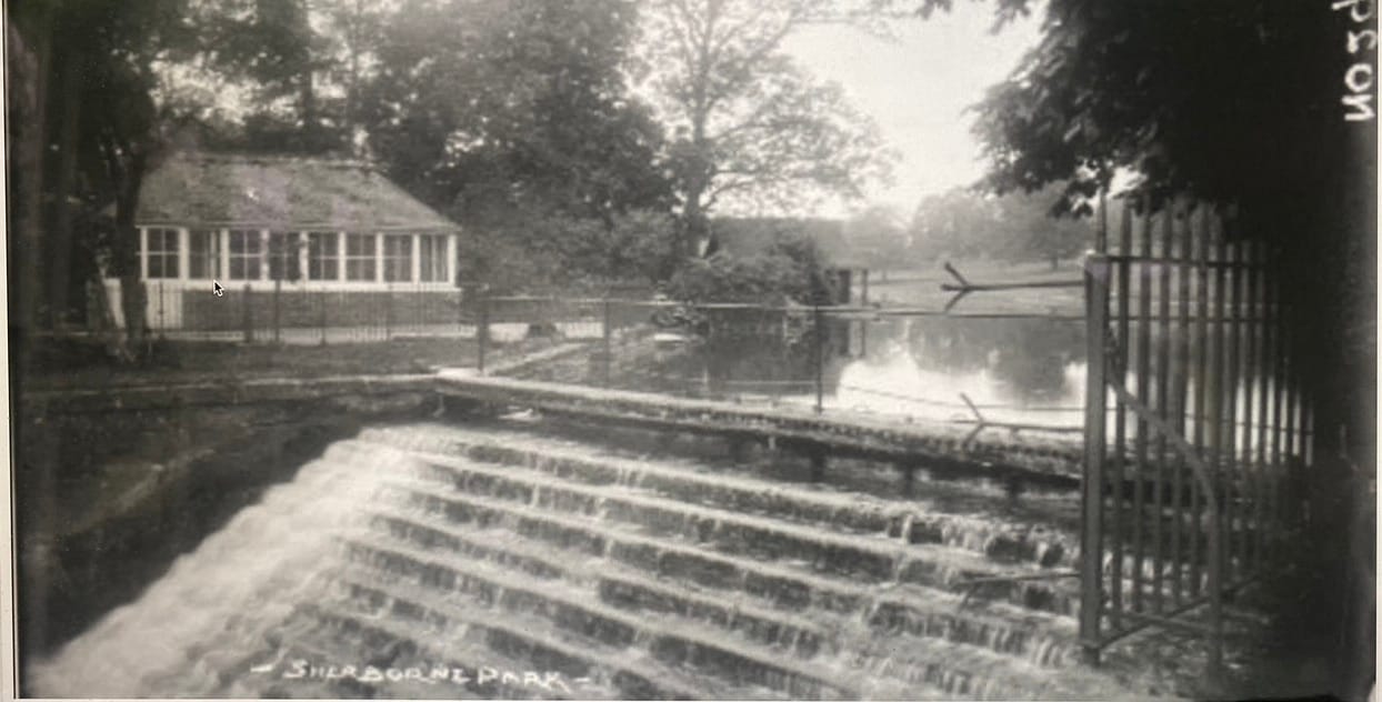
Both dams are familiar landmarks to anyone who knows our Brook. The upper dam sits in relatively open ground and is the more immediately visible of the two. The lower dam is tucked behind a tongue of woodland, but it is the larger and more substantial structure — with a drop of around fifteen feet compared with the upper dam's eight. These are not casual features. They represent a significant and deliberate reshaping of the valley bottom.
The upper dam is the older of the two, and very likely considerably older than any documentary record confirms. A bird's-eye drawing of the Sherborne estate made by the engraver Johannes Kip in 1709 appears to show a dam structure at this location, with what can be interpreted as four through-pipes and a sluice gate mounted on top. This is open to interpretation — Kip's drawings are artistic as well as documentary — but the structure depicted is consistent with a managed water feature rather than a natural stream crossing. The Kip drawing establishes that something was here by 1709; it does not tell us when it was first built. Given the depth of water management history in this valley, it may be considerably earlier.
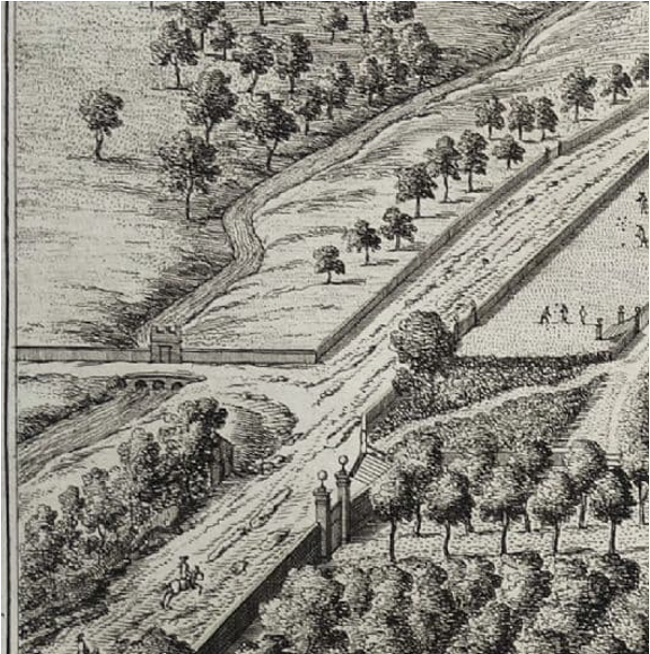
(An excerpt from Kip's c1709 drawing of Sherborne. Note the apparent weir with four through-pipes surmounted by a sluice mechanism. Today's weir is in the same place, and retains a sluice. )
This upper dam survives today as a functional crossing. A cobbled ford and a footbridge run across the top of the structure — a practical function it has likely served for centuries. It is visible from the village road and from the edge of the lawn at Sherborne House, sitting in the middle ground of a designed landscape shaped and reshaped since at least the early eighteenth century.
The lower dam we believe dates from 1739 to 1740. The Dutton estate accounts for that period record expenditure on masonry works to create a "pond" — the term then used for an impounded lake — together with sluices and grates on the waterway. Visible masonry of the period can still be seen today, forming the lower of two sluices in the lower dam — physical corroboration of the archival record.
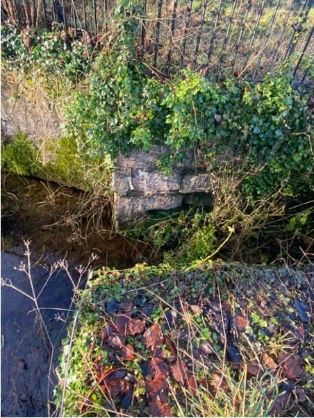
(The lower sluice on the lower dam showing an earlier masonry construction compared to the brick lined upper sluice.)
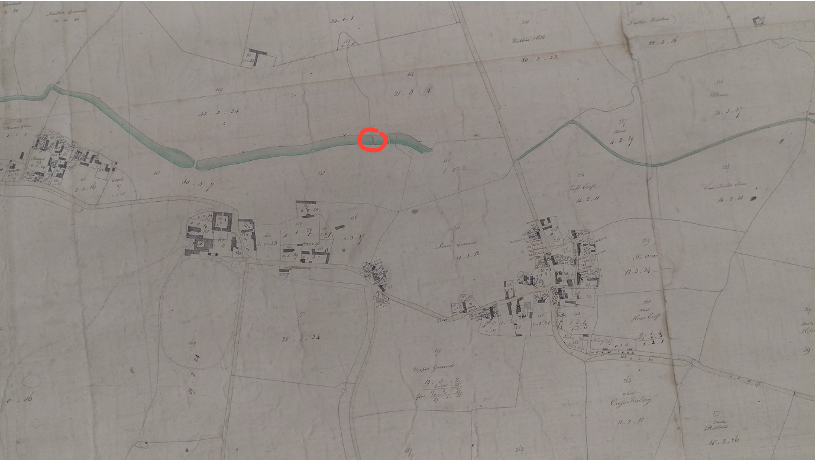
It has been suggested that the lower dam was constructed much later, sometime between 1815 and 1820, apparently on the basis of early Ordnance Survey mapping. We believe this is a misreading of those sources. English Heritage themselves support the view that Taylors 1777 map of Gloucestershire represents two lakes. The one-inch to one-mile OS map represents a narrow valley lake as a thin line at that scale, indistinguishable from an unimpounded stream. That is simply what a feature of this width looks like at 1:63,360 scale — it is not evidence of absence. Two large-scale Dutton estate plans, one dating from around 1818 and one from around 1820, both clearly show the lake as a formed, established feature. If the dam were being constructed between 1815 and 1820, it could not already appear as a settled landscape element on a surveyed estate plan of 1818. And in 1827 the first formal Ordnance Survey Map, as such, the brook is shown correctly scaled again. Bottom line on a 1 inch to one mile map it is impossible to show a lake 30 yards wide as anything other than a thin line. Here's a c1818 large scale state plan showing a lake and below it the later 1827 OS map which can't show the lake because of the scaling.
The Dams Themselves: A Note on Their Character
Early twentieth-century photographs show that both dams were originally constructed with their downstream faces formed as a series of steps — a classic masonry dam profile, functional and relatively straightforward in appearance.
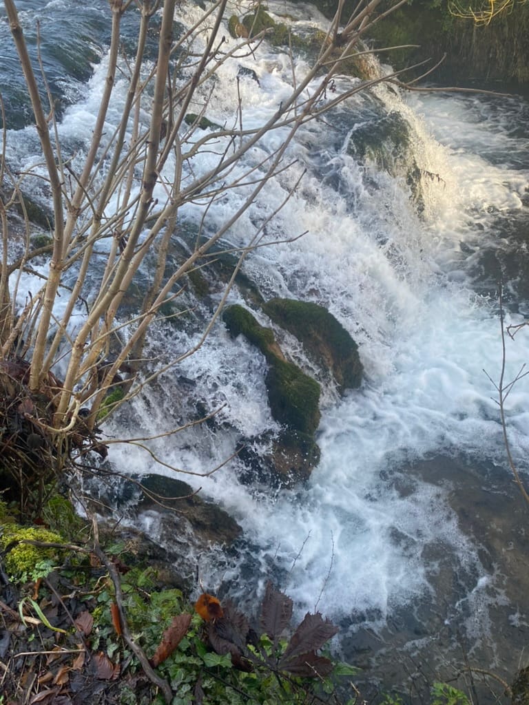
What those photographs also reveal, by contrast with what we see today, is the remarkable transformation wrought by time, water, and limestone. Sherborne Brook is a limestone-fed stream, and its water is rich in calcium carbonate. Where that water tumbles, splashes, and seeps over the downstream face of the dams, it degasses and deposits its mineral load on whatever surface it meets — stone, weed, or organic debris. The result is calcareous tufa: a pale, porous, organically shaped deposit that accumulates over decades into complex, rounded, almost sculptural forms. The original stepped masonry of both dams has been largely moulded and softened by this process into something quite different from what was built. It is, in its way, a living record of the water's chemistry — and a reminder that these structures have been interacting with the brook for a very long time.
A Valley With a Long Memory
Before turning to the purposes of the two dams, it is worth stepping back to appreciate just how deep the tradition of water management runs in this valley.
Four mills are recorded on Sherborne Brook in the Domesday Book — nearly a thousand years ago. All four lay within the parish, probably upstream of the lower dam site, the first being right on the boundary with Farmington - the mill pond at within the Parish of Farmington and a mill fed by a leat, still visible today if one looks carefully just over the parish border in Sherborne. Ducklestone Mill (once called Sherborne Mill ) sits just upstream of Haycroft. Elsewhere the presence of Fullers Earth beside Waterloo bridge gave another important slice of history with a a very early fulling mill sitting a 100 yards above Waterloo Bridge, turning woollen cloth into felt. This again is geology and geography providing historical character and heritage to Sherborne. Each mill required its own head of water: a weir, a millpond, a managed flow. The brook has been a working, engineered watercourse for at least a millennium and probably more.
By 1622, an estate survey undertaken by Crump Dutton records six pools of considerable acreage on Sherborne Brook. Open water in this valley bottom is not a modern amenity or an eighteenth or nineteenth century affectation. It is a continuation of a tradition stretching back to the Norman Conquest and beyond.
The lower dam of 1739–40 should be read in this context. It did not introduce water management to Sherborne Brook. It continued and elaborated a practice already ancient.
Why Were They Built? Several Good Reasons
Ornamental Water
The most visually obvious purpose is also the most straightforward. Both bodies of water are visible from Sherborne House and its grounds. The 1739–40 construction date for the lower dam falls squarely within a period of active landscape improvement at Sherborne — the era of formal and naturalistic garden design that transformed English country house estates throughout the eighteenth century. Still water in a valley setting, reflecting sky and trees, was a primary design objective of the period. The dams created exactly that. The fact that the lower dam is hidden, tucked away behind trees, is a characteristic of 18th C lake design, supposedly to encourage the imagination that the lake continues out of sight.
Fish Management
Impounded water on an estate brook served a productive as well as an aesthetic purpose. Still and slow-moving water supports fish populations differently from the faster-flowing brook — providing holding water, feeding habitat, and controlled access for management. Fish management was a standard dual use of ornamental lakes on Cotswold estates. Indeed it would be essential to the monastic estate that Sherborne once was.
The upper dam may also have served an older and more utilitarian purpose in this regard. Sherborne's historical records document the washing of thousands of sheep in the river here during the medieval period, and a controlled depth pool above a dam would have provided exactly the calm, contained water that made sheep washing practical.
The Drowned Meadow
Downstream of the lower dam, the final field before the brook reaches the River Windrush is recorded in documents of 1820 as "Drowned Meadow." This is significant supporting evidence for the dam's role in water meadow management.
Field names of this kind reflect established local usage. A surveyor records what the landscape is already called. "Drowned Meadow" describes a water meadow management regime — the deliberate flooding of grassland in late winter and early spring to protect the sward from frost, accelerate early grass growth, and improve hay yields. It was a sophisticated and labour-intensive practice, widely used across the Cotswolds and Thames Valley in this period.
The physical evidence is consistent with the name. A sluice gate on the brook bank at this point, marked on historic maps and with surviving masonry remains, fed water directly into the meadow by gravity. Within the meadow itself, ridge and furrow carrier channels confirm that water was actively distributed across the surface in a managed drowning regime.
It is also worth noting that the course of Sherborne Brook below the lower dam has not always followed its present route. At some point — the date is not established — the brook was engineered away from its former meandering course through the adjacent meadow known as Cowham. This is further indication of deliberate landscape engineering in the valley bottom, consistent with the broader programme of works of which the lower dam appears to form a part.
A Later Adaptation: Electricity Generation
The lower dam's history did not end in 1739–40. Around 1898, the structure was adapted with the addition of a brick sluice housing a turbine to generate electricity for Sherborne House. This further use illustrates the dam's adaptability over a century and a half of changing needs .
Why Not a Mill?
It has been suggested that the lower dam was built to provide water power to a mill on the River Windrush, lying some three miles downstream.
We do not find this convincing, for reasons that are straightforward once the hydraulics are understood. We have consulted hydrological engineers to confirm this.
A watermill is powered by head — the vertical difference in water surface elevation immediately above and below the mill wheel. Head is a strictly local quantity. It is created at the mill by the miller's own weir and sluice. It cannot be generated at a distant point and transmitted downstream through an open channel.
As water flows away from any dam, it expends its stored energy maintaining motion against friction. "Manning's equation" — the standard engineering formula for open channel flow — quantifies this loss as proportional to channel length and roughness. Over five thousand yards of sinuous, vegetated limestone-fed stream, the energy dissipation is total. Nothing useful in terms of energy reaches Windrush Mill.
When the brook does reach the Windrush, it joins a larger river at that river's own energy level. The mill's water surface is governed entirely by the Windrush's own discharge and channel geometry. A tributary joining upstream adds volume — but zero additional head. The mill simply cannot feel the effect of a dam on Sherborne Brook.
The Dutton estate accounts of 1739–40 record building of sluices and gates on the waterway. They contain no reference to Windrush Mill, no milling agreement, and no arrangement of any kind connecting the dam to a downstream mill. The absence of such a record, in accounts that do record detailed waterway expenditure, is telling. Those who have suggested this purpose have been invited to provide documentary substantiation. None has been forthcoming.
Furthermore, if water power were the objective, the brook already had a long and well-documented milling history upstream. Four Domesday mills on the brook demonstrate that its flow was capable of powering mills — but those mills were on the brook itself, where head could be created and used locally. No competent engineer — whether in 1740 or in 1820 — would have proposed powering a mill three miles away on a different river. The hydraulic principles that make such a scheme impossible were well understood in both periods.
The Silting Problem — and Why It Is Now Solved
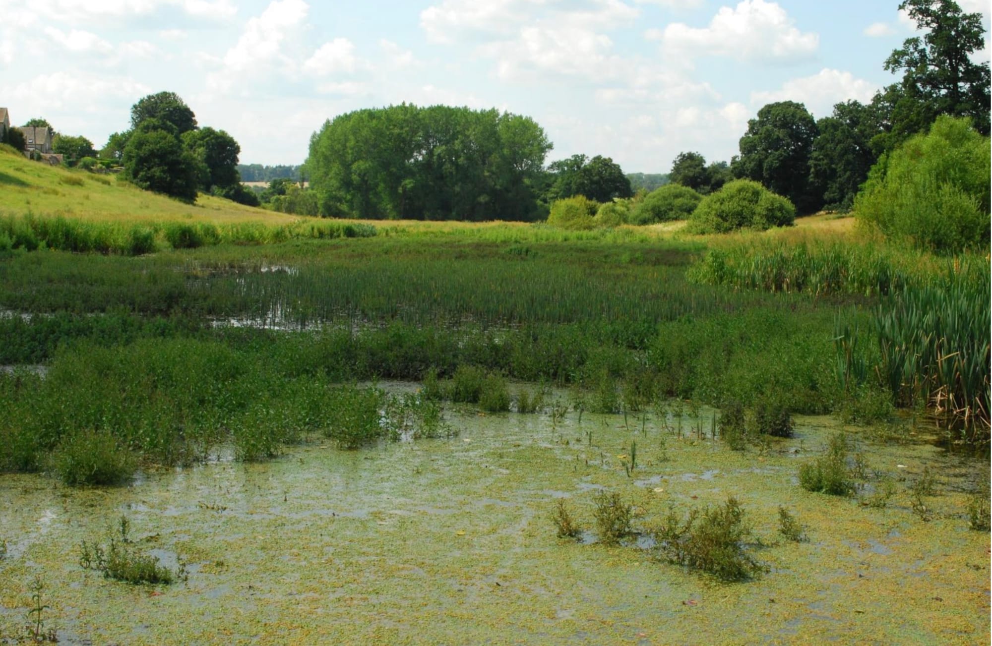
Both lakes have silted up progressively over recent decades, with vegetation advancing year on year until very little open water remains visible in summer. Understanding where that silt came from matters — because the case for dredging depends on knowing whether the problem would simply recur.
We believe the silt entered the system from two sources. The first, further upstream, has already been addressed. Around three to four years ago, the late Patrick Paul undertook a careful and considered dredging of the lake at Haycroft, approximately 400 metres upstream of our two lakes. That intervention removed a significant upstream silt source, indeed created silt trap and has measurably improved conditions on the brook downstream.
The second and more significant source was road runoff from Waterloo Bridge. Dirty surface water from both sides of the bridge ran down the banks and directly into the brook, carrying a sustained load of fine silt into the system year after year. That source has now been resolved with the NT, the Brook group and the Highways working to prevent it occurring once more
The result is striking. Over the last year or so, Sherborne Brook has been running clearer than it has in living memory. This is, in a sense, a return to origins: the name Sherborne is attributed to the Old English for a clear, bright stream. The brook is living up to its name once again.
The significance for the lakes is straightforward. No more silt is entering the system in meaningful quantities. Removing silt and the consequent vegetation load from the lakes is therefore, at last, a sustainable proposition — not a temporary fix that would need repeating within a generation, but a lasting restoration of open water to a valley that has supported it for a thousand years.
Furthermore the NT has excellent plans for a wetland downstream, beyond the constraints of a grade 2 listed parkland, around Cowham meadow, in an area that would likely get great support from the local community. There is a win-win solution waiting to happen.
Why It Matters
The case for restoring these water bodies rests on understanding what they were actually built for. Ornamental water, fish habitat, a functioning water meadow system, and a landscape tradition stretching back to the Domesday Book are all purposes that restoration would serve. There is an ecology too for open water. It may not be as broad, ecologically speaking as a swamp, but nonetheless it's historically significant in this case.
Sherborne Brook is a limestone-fed stream with the character and water quality of a chalk stream — clear, cold, and of high ecological value. Open water in a valley setting of this kind supports aquatic and riparian life that enclosed, vegetation-dominated channels cannot sustain. A thousand years of managed open water in this valley has shaped its ecology as well as its landscape. The loss of open water is a loss of habitat as well as history.
We hope that those responsible for the management of this landscape will take the opportunity now before them and recognise the public benefit that maintaining open water in Sherborne implies. Wetland would be fabulous downstream, where the heritage case is much weaker.
Finally as a throw away line. We know that Charles Bridgeman was consulted by Sir John Dutton in the 1720s and 1730s. We know that Charles Bridgeman utilised the concept of a valley bottom with successive lakes elsewhere in his designs. We know from archives that the lower lake at Lodge Park was built around 1739 (It disappeared in the mid 1800s). We know that Sir John Dutton's will of 1743 instructed his heirs to continue Bridgeman's designs at Lodge Park, the Lower lake having been constructed 3 years earlier, perhaps to Bridgeman's revised design after the original plan for a great Serpentine lake proved impossible. If the lower lake in Lodge Park was, just possibly, a Bridgeman feature built in 1739/1740 can we look across to Sherborne Park and see a similar lake being built at the same time, and suspect the faintest possibility that it is a Bridgeman feature? John Phibbs has identified the yew/box terrace at the entrance to Sherborne House as having the characteristics, maybe, of a Bridgeman design. Is it just possible that the Sherborne Brook lakes hold one more secret? A secret that may be lost forever beneath a wet willow swamp, if the decision is simply to do nothing.
The Sherborne Brook Support Group monitors local water quality, and ecological conditions on the Sherborne Brook .